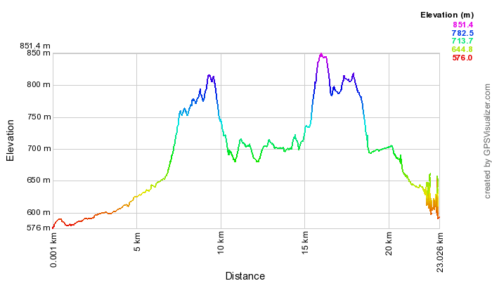
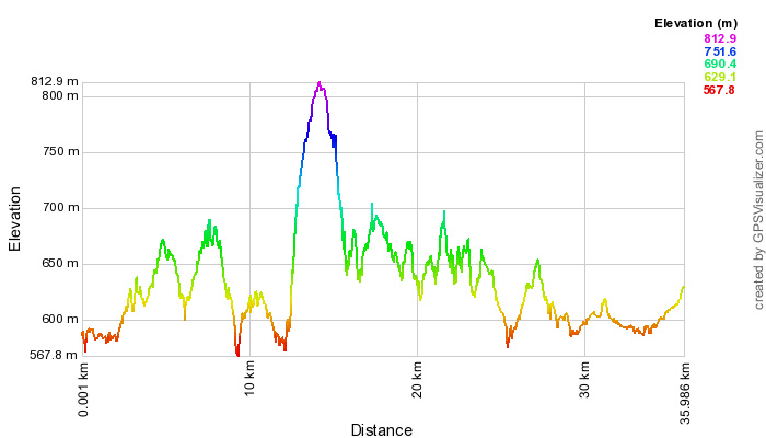
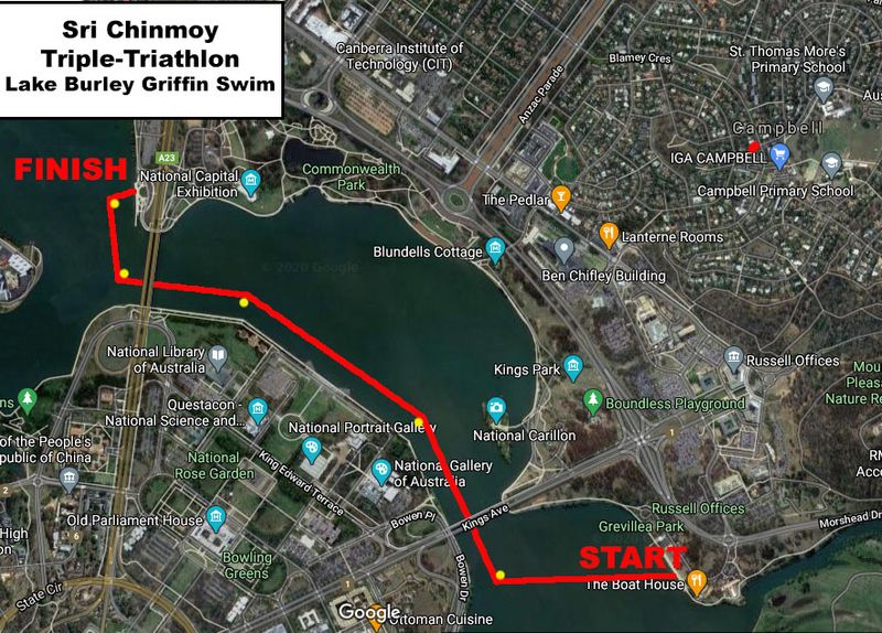
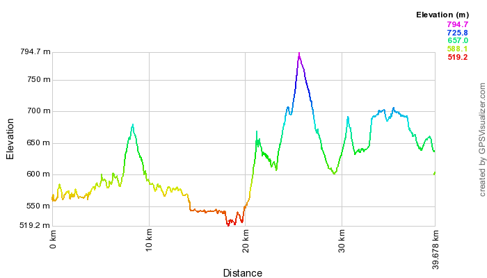
View and download the full course on Garmin Connect. Enjoy a GoPro tour of the entire course as ridden by Andrew Oberg (updated for 2023).
Follow the cycle path north, then almost immediately taking a left-hand fork (do NOT go under the bridge) to bring you onto the Ginninderra Dr bridge crossing the lake. Continue following the cycle path around the shoreline. Just after John Knight Memorial Park, turn left at a fork in the cycle path, travelling under Aikman Drive and into the University of Canberra.
Follow the pathways through the University, crossing over College St at the pedestrian traffic lights. After crossing College St, follow the bike path beside Haydon Dr. Cross over Battye St, before turning right to climb over the wooden access gate into the Nature Reserve on Gossan Hill.
Follow the fire road with a fence on your right for a few hundred metres. Head uphill to the left at a fork in the road. Turn right at the next crossroads. Take the left of the two 'straight ahead' options at the 5-way intersection when you reach the top of the crest. You are now heading along the crest of Gossan Hill, through eucalyptus forest. Veer right at the fork in this track, then left onto the bitumen road (thus avoiding the deep kerb), and left again off this road onto the footpath leading towards the Belconnen Way overpass.
Across the overpass, follow the cycle path through the Aranda District Playing Fields. Go under Bandjalong Cres, straight up past the Aranda shops on your left and uphill on the concrete path. Cross over Walu St, and after a brief dirt section rejoin the footpath, still heading up. At the top, go through the walkers' gap in the fence, then immediately left.
With Telstra Tower and Black Mountain looming straight ahead, the track dips. Take the first available sharp right, immediately before the power lines. Follow this track in line with the power lines through a dog-leg left-right, down a long hill. Turn left onto another track at the bottom of the descent, immediately after a large power line pylon. Follow this track around the base of Aranda Hill as far as it goes, eventually turning to your right onto the road at the base of the Gungahlin Drive Extension, leading up to the underpass under the GDE. Pass under the road.
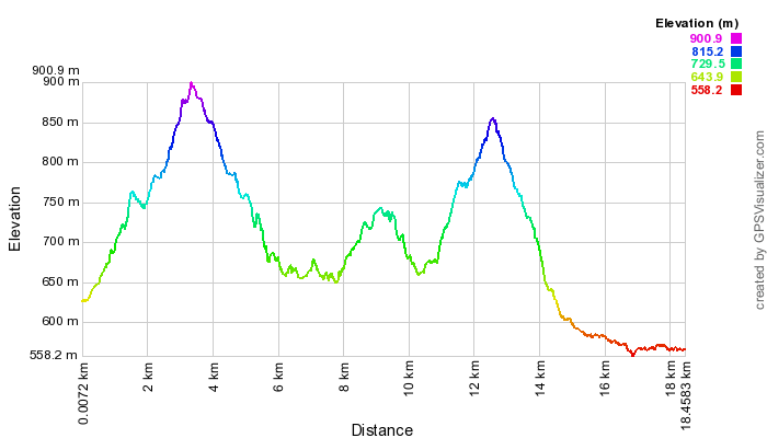
You are now in Black Mountain Reserve. Take the first right hand fork in the track. There are no turns for a few kilometres as you enjoy a pleasant ride around the base of Black Mountain, through natural gum forest and open spaces. At the end of this section, veer left back into the bush, heading uphill. Go right at the T-junction, down a sharp rocky slope and through a dry creek bed. Upon rising out of the creek bed, the track swings to the left and you are confronted with the infamous, though now graded "Push-Bike Hill." ...
Just before the gate at the top, take a tiny trail veering to the left, which leads out onto the road without having to climb a gate. Be alert for traffic, as you turn left (uphill), and follow the road to the summit of Black Mountain, where the road loops around before descending. There is an aid station at the top.
On the way down, continue on the road past the picnic ground car park, then about 500 metres later, turn left opposite the water reservoir on your right onto another 4WD track, heading once more downhill. This track winds around the flank of the mountain, and after a few gradual rises and a descent comes to a metal gate with a walkers' entrance beside it.
Passing through this entrance, follow the track to the left before turning right onto a large dirt road (Frith Road) which you follow downhill for approx. 300m before turning left to pass through another walkers' gate and follow the dirt road that climbs up next to the electricity substation. Just after the substation take care to veer off the road to the right to follow the embankment and follow the Canberra Centenary Trail (CCT) single track, that runs under the powerlines. After approx 300m the CCT drops off the embankment to the right to descend to Frith Rd. Cross straight across the road, and then turn left to head through the Barry Dr. underpass on the LHS. After exiting the tunnel turn hard left at the CCT/Stop sign to take a single track heading uphill into the trees. Follow the CCT track all the way through to the roundabout at Fairfax St/Dryandra St Belconnen Way. Follow the Course Marshal's instructions to cross the road.
Enter the Bruce Ridge reserve through the gap in the fence on the corner of Fairfax St and Dryandra St. Follow the obvious single track here (Box Gum Margin). Turn left onto the Heath Run, into Belco Switchbacks. Follow this into the Burin single track. Turn right onto Happy Wanderer, then left at Northface (via a link trail). Veer right at Commuted and follow it to where it joins a track under the powerlines. Turn left onto this track, which leads down to a wooden gate in the fence. Pass to the left of the gate, cross over the cycle path, pass between some boulders by a metal gate, then follow the track that veers up to the right.
At the top of the rise, swing to the left along O'Connor Ridge, then turn right at the next small signpost onto a "Multiple Use Track". This smaller track brings you around the side of O'Connor Ridge, then along the top of a small levee, eventually veering to the right, leading you to a gate. Climb the gate, and head left onto Dryandra St, which then turns right and becomes Archibald St. Pass the Ukrainian Catholic Centre, Ursula College Lyneham Centre, St Joseph's House of Studies, and the Sakyamuni Buddhist Centre. Turn left onto the footpath leading alongside the Buddhist Centre, which overpasses Ginninderra Dr and brings you into North Lyneham.
After the overpass, turn immediately left into Cossington Smith Cres, then left again into Fred Williams Cres, left into Duterrau Cres, and left into Lewers Close. Continue straight onto the track at the end of Lewers Close, which climbs and then flattens out. Look for a small gap in the fence on your right. Go through here, then turn left onto a main dirt track. This track first heads down, then veers twice to the right while climbing, then once to the left before starting to descend.
Turn left at the next T-junction, then right again after 20 metres. When this track comes to a gateless gate, turn to your left. Veer slightly to the right and cross the horse logs. As you follow the trail out of the trees, turn right, heading towards Ellenborough St. Turn right onto the Kaleen cycle path. After a short distance, turn left, at the new cycle path crossing. After crossing Ellenborough St, turn right, following the cycle path. Turn left at the next junction. Continue along this cycle path under the Barton Highway, and parallel with the highway on the other side.
At the Gungahlin Dr fly-over, this cycle path follows Gungahlin Dr around to the right. Follow this cycle path all the way to Sanford St, turning right.
Continue to Hoskins St and turn right. Continue south towards Bellenden St (the old course, now heavily fenced). Continue south at this junction passing the Community Garden. At the end of this road, turn left onto the equestrian trail, alongside a stand of gum trees. This section is notoriously muddy after rain. Follow the equestrian trail to the end, then turn right onto a bitumen service road. Follow this road to Randwick Rd. Turn left onto Randwick Rd.
Cross over Flemington Rd, then follow the cycle path to the right, past EPIC on your left. Cross over the Federal Hwy at the lights. Go straight ahead on the other side of the highway, then turn left onto the narrow dirt track beside the line of trees. Veer to the right as you approach Stirling Ave. Cross over Knox St at the junction of Stirling Ave, straight through the gap next to the gate. After 50m, take the trail to the left, then veer right and follow this track onto the dirt road. Note that this area is a popular area for dog-walking and off-leash dogs – PLEASE look out for pedestrians walking their dogs and for off-leash dogs and give them right of way at all times. Finish at the bus stop on Antill St.
<Previous | Next> Back to Contents
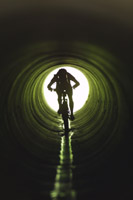 After this track smooths and flattens out, take the first right into the bush up a rocky sidetrack, then right again at a fork. At the fence, go through the wooden opening, then turn immediately right at the main track, through the tunnel to pass back under Erindale / Yamba Dr.