
AustraliaSri Chinmoy Marathon Team

  • About us
  • Our races
  • Results

Search form

Founded by Sri Chinmoy in 1977, the Marathon Team is one of the world's largest organisers of endurance events.
read more »

Gallery

Thousands of event images

History

From 2 to 3100 miles

Sri Chinmoy

Marathon Team Founder

Next Event:

11 May - Canberra
Sri Chinmoy Canberra Trail Series
Details »

More events:

Brisbane
Canberra
Jindabyne
Melbourne
Sydney
View all events »

Worldwide:

View full list »

Latest results:

25 April - Canberra
Sri Chinmoy Canberra Trail Series 1: "Cooleman Clip" 10km, 5km & 2.2km, Friday 25 April 2025
Details »

Previous races

View all results »

Worldwide results

Full list »

Sri Chinmoy Labour Day 10 km & 4 km Fun-Runs, 2013 – Results

By Prachar Stegemann
6 October

The Sri Chinmoy Labour Day 10 km & 4 km Fun-Runs for 2013 were held on Monday 7 October from Acton Ferry Terminal.  Full results for both distances follow:

Sri Chinmoy Labour Day 10 km run, 7 October 2013, full results>>

Sri Chinmoy Labour Day 4 km run, 7 October 2013, full results>>

Sri Chinmoy Marathon Team articles - more articles

Leg 9 - Mountain Bike 42.8 km

By Prachar Stegemann
12 March

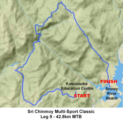
The 3rd mountain bike leg is by far the longest leg of the day, starting with a climb on the road and the highest point on the course, another gruelling climb after crossing the Snowy River and a net descent from top to bottom of 700 metres through the forests adorning the edge of Australia's highest mountain range. Note that cyclists MUST carry their own water or other replacement fluid.

leg9multisport.jpgView and download this course on Garmin Connect.

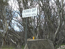
Starting from the Kosciuszko Education Centre on Kosciuszko Rd, turn onto Kosciuszko Road heading solidly uphill for the first 8 kilometres as far as Rennix Gap, at 1600 metres the highest point on the course so far.

400 metres after Rennix Pass, turn right onto the road to Guthega, with about 4 kms of downhill riding, still on bitumen.

Though it is tempting to speed on this section, be extremely alert for cars coming in the opposite direction and DO NOT cross onto the right hand side of the road under any circumstance!

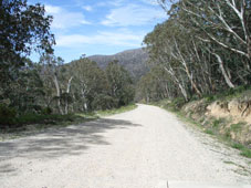
Turn right at the fork towards Island Bend, which leads right into gravel with several options but no signposts. Take the furthest right of these options, heading slightly downhill into the bush. You will pass by two turn-offs to Island Bend Dam on your left. Glide downhill through forest which was completely burned out in the January 2003 bushfires, but has shown remarkable recovery. Continue for about 6 kms on this dirt road, ignoring all turn-offs to your right. The road bends sharply to your left, then you cross the Snowy River (or what is left of it).

Take the trail directly ahead after the bridge and begin climbing, and climbing, and climbing. The following climb is graded about "Push Bike Hill" x 4 ("Push Bike Hill" is the climb up Black Mountain on the first mountain bike leg of the Triple-Tri). After 2.5 kms of climbing, turn hard left at the next fork in the trail, passing around a gate onto the Gungarlin Fire Trail. The next 200 m are the steepest part of the climb.

The climb plateaus briefly half way up before following power lines to the top of the hill (6 kms and 500 m vertical climb from the Snowy River crossing).

This trail continues to undulate downhill through forest, with spectaular views across to the east. After about 2km turn sharply right onto the Botherum Trail, which is signposted but easy to miss as you descend, located 300 m before a bridge crossing over a creek at the bottom of the descent. If you come to this bridge, you have come too far!

Follow this trail east through the open grass Botherum Plain and over the Gungarlin River, where you may get wet feet. The trail continues past the large boulder on your right known as Kalkite Rock, then up over a small rise and through Kalkite Gap before the descent - 600 m vertical over 7 kms - towards Lake Jindabyne. Take great care, as sections of this descent are deeply rutted.

You are heading directly towards the start of the race at North Kalkite Boat Ramp on the opposite shore. Turn right about 500 m before the lake and follow a faint trail south through mostly open grassland to finish at Snowy River Beach, opposite Waste Point. A ferry service will transport cyclists to Creel Bay and your waiting support crews.

For detailed course descriptions and maps of other legs, select from the list below.

Leg 1 Swim 1.5 km Course Description
Leg 2 Paddle 9 km Course Description
Leg 3 Run 6 km Course Description
Leg 4 Mountain Bike 8 km Course Description
Leg 5 Swim 2.5 km Course Description
Leg 6 Paddle 5km Course Description
Leg 7 Mountain Bike 9 km Course Description
Leg 8 Run 12.5 km Course Description
Leg 10 Swim 1.2 km Course Description
Leg 11 Paddle 9.5 km Course Description
Leg 12 Run 5 km Course Description


View full article »

Leg 8 - Run 11.3 km

By Prachar Stegemann
12 March

NOTE: THIS COURSE HAS BEEN AMENDED FOR 2024

The 2nd run leg is the most challenging of the three - a genuine cross-country run on walking trails through natural forest. Take care as the footing is quite uneven and requires full concentration. Please note that runners MUST carry their own water or other replacement fluid.

View and download this course on Garmin Connect.

Starting from the NEW TRANSITION AT THE TREDBO RIVER PICNIC AREA (turn left off Kosciuszko Rd as you are heading west into the National Park, immediately after you cross the Thredbo River), look for the signs designating the beginning of the Pallaibo Walking Track and Thredbo Valley Track. These tracks are the same for the first 500m of newly constructed trail. THIS IS DUAL USEAGE TRAIL, SO PLEASE BE ALERT FOR BIKES COMING THE OTHER WAY!

After 500m, look out for the fork heading to your RIGHT, where the Pallaibo Trail veers away from the main Thredbo Valley Track, to head uphill. The trail rises, ascends, then continues to climb. After several kms, take the right hand option at a fork in the track, which will bring you out at the Sawpit Creek picnic area, where you turn to your left into the picnic area.

Continue through the picnic area directlyonto the Waterfall Track, which heads under the bridge over Sawpit Creek. Head to your left onto this trail.

This track, which is another designated walking trail, takes you through bushland which was completely burned out in the fires of January 2003.

The trail takes its name from a pretty waterfall on Sawpit Creek at the far end of the loop, though flows are dependent on rainfall or snow melt.

Continue past the waterfall, all the way around the loop until you return through the underpass under Kosciuszko Rd to the Sawpit Creeek picnic area. Run through the picnic area, then turn left onto the walking track for another 400 metres to bring you to the Kosciuszko National Park Education Centre and the transition.

sri_chinmoy_multisport_classic_leg8

For detailed course descriptions and maps of other legs, select from the list below.

Leg 1 Swim 1.5 km Course Description
Leg 2 Paddle 9 km Course Description
Leg 3 Run 6 km Course Description
Leg 4 Mountain Bike 8 km Course Description
Leg 5 Swim 2.5 km Course Description
Leg 6 Paddle 5km Course Description
Leg 7 Mountain Bike 9 km Course Description
Leg 9 Mountain Bike 42.8 km Course Description
Leg 10 Swim 1.2 km Course Description
Leg 11 Paddle 9.5 km Course Description
Leg 12 Run 5 km Course Description


View full article »
  • ‹ previous
  • 19 of 34
  • next ›
More articles under Sri Chinmoy Marathon Team articles »

Sri Chinmoy Marathon Team articles

main page »

Stories from around the world

United States
3, 6 and 10 Day Race 2025
3100 Mile Race
3100 Mile Race - Past and Present
3100 Mile Race
2024 Final Results of 3100 Mile Race
3100 Mile Race
Sri Chinmoy 3100 mile race. The first 10 days.
Worldwide
Start of 3100 Mile Race 2024
Worldwide
Dipali Cunningham Inducted into AUTRA Hall of Fame

About us

  • About the Marathon Team
  • Sri Chinmoy, Team Founder

Our races

  • View all events

Results

  • Previous races
  • Worldwide results
Global homepage »

Country Websites

  • W.Europe
    • Austria
    • Finland
    • France
    • Germany
    • Great Britain
    • Iceland
    • Ireland
    • Italy
    • Netherlands
    • Norway
    • Portugal
    • Switzerland
  • Central & E. Europe
    • Belarus
    • Bulgaria
    • Croatia
    • Czech Republic
    • Hungary
    • Latvia
    • Macedonia
    • Moldova
    • Russia
    • Serbia
    • Slovenia
    • Slovakia
    • Ukraine
  • N. & S. America
    • Brazil
    • Canada
    • Guatemala
    • United States
  • Asia
    • Japan
    • Mongolia
  • Oceania
    • Australia
    • New Zealand

Other sites

  • Sri Chinmoy Cycling Team
  • SCMT Channel Swimming
  • SCMT Climbing
  • 3100 Mile Race

Popular Pages

  • 3100 Mile Race
  • Recent media coverage
  • History 1977-Present
  • Our members
  • Log in

Contact Information

Sri Chinmoy Marathon Team
Brisbane • 87 Pembroke Rd Coorparoo QLD 4151 • 0450 765 315 • Email us
Canberra • Shop G, 1B Dickson Chambers, Dickson ACT 2602 • +61 404 071 327 • Email us
Melbourne • PO Box 3247 Cotham VIC 3101 • 0407 333 740 • Email us
Sydney • Shop G, 1B Dickson Chambers, Dickson ACT 2602 • +61 404 071 327 • Email us
Creative Commons License

Except where explicitly stated otherwise, the contents of this site are licensed under a Creative Commons Attribution-NonCommercial-NoDerivs 3.0 Unported License read more »

SriChinmoyRaces.org is a Vasudeva Server project.