AustraliaSri Chinmoy Marathon Team

  • About us
  • Our races
  • Results

Search form

Founded by Sri Chinmoy in 1977, the Marathon Team is one of the world's largest organisers of endurance events.
read more »

Gallery

Thousands of event images

History

From 2 to 3100 miles

Sri Chinmoy

Marathon Team Founder

Next Event:

2 June - Canberra
Sri Chinmoy Canberra Trail Series
Details »

More events:

Brisbane
Canberra
Jindabyne
Melbourne
Sydney
View all events »

Worldwide:

View full list »

Latest results:

11 May - Canberra
Sri Chinmoy "Stromlo Strides" 15.4km, 6.3km & 2km trail runs, Sunday 11 May 2025
Details »

Previous races

View all results »

Worldwide results

Full list »

Sri Chinmoy Labour Day 10 km & 4 km Fun-Runs, 2013 – Results

By Prachar Stegemann
6 October

The Sri Chinmoy Labour Day 10 km & 4 km Fun-Runs for 2013 were held on Monday 7 October from Acton Ferry Terminal.  Full results for both distances follow:

Sri Chinmoy Labour Day 10 km run, 7 October 2013, full results>>

Sri Chinmoy Labour Day 4 km run, 7 October 2013, full results>>

Sri Chinmoy Marathon Team articles - more articles

Leg 2 – 38km Mountain Bike

By Prachar Stegemann
14 November

View and download the full course on Garmin Connect. Enjoy a GoPro tour of the entire course as ridden by Andrew Oberg (updated for 2023).

Follow the cycle path north, then almost immediately taking a left-hand fork (do NOT go under the bridge) to bring you onto the Ginninderra Dr bridge crossing the lake. Continue following the cycle path around the shoreline.  Just after John Knight Memorial Park, turn left at a fork in the cycle path, travelling under Aikman Drive and into the University of Canberra.

Follow the pathways through the University, crossing over College St at the pedestrian traffic lights.  After crossing College St, follow the bike path beside Haydon Dr. Cross over Battye St, before turning right to climb over the wooden access gate into the Nature Reserve on Gossan Hill.

Follow the fire road with a fence on your right for a few hundred metres. Head uphill to the left at a fork in the road. Turn right at the next crossroads. Take the left of the two 'straight ahead' options at the 5-way intersection when you reach the top of the crest.  You are now heading along the crest of Gossan Hill, through eucalyptus forest. Veer right at the fork in this track, then left onto the bitumen road (thus avoiding the deep kerb), and left again off this road onto the footpath leading towards the Belconnen Way overpass.

Across the overpass, follow the cycle path through the Aranda District Playing Fields. Go under Bandjalong Cres, straight up past the Aranda shops on your left and uphill on the concrete path. Cross over Walu St, and after a brief dirt section rejoin the footpath, still heading up. At the top, go through the walkers' gap in the fence, then immediately left. 

With Telstra Tower and Black Mountain looming straight ahead, the track dips. Take the first available sharp right, immediately before the power lines.  Follow this track in line with the power lines  through a dog-leg left-right, down a long hill.  Turn left onto another track at the bottom of the descent, immediately after a large power line pylon.  Follow this track around the base of Aranda Hill as far as it goes, eventually turning to your right onto the road at the base of the Gungahlin Drive Extension, leading up to the underpass under the GDE.  Pass under the road.

You are now in Black Mountain Reserve. Take the first right hand fork in the track. There are no turns for a few kilometres as you enjoy a pleasant ride around the base of Black Mountain, through natural gum forest and open spaces. At the end of this section, veer left back into the bush, heading uphill. Go right at the T-junction, down a sharp rocky slope and through a dry creek bed. Upon rising out of the creek bed, the track swings to the left and you are confronted with the infamous, though now graded "Push-Bike Hill." ...

Just before the gate at the top, take a tiny trail veering to the left, which leads out onto the road without having to climb a gate. Be alert for traffic, as you turn left (uphill), and follow the road to the summit of Black Mountain, where the road loops around before descending. There is an aid station at the top.

On the way down, continue on the road past the picnic ground car park, then about 500 metres later, turn left  opposite the water reservoir on your right onto another 4WD track, heading once more downhill. This track winds around the flank of the mountain, and after a few gradual rises and a descent comes to a metal gate with a walkers' entrance beside it.

Passing through this entrance, follow the track to the left before turning right onto a large dirt road (Frith Road) which you follow downhill for approx. 300m before turning left to pass through another walkers' gate and follow the dirt road that climbs up next to the electricity substation. Just after the substation take care to veer off the road to the right to follow the embankment and follow the Canberra Centenary Trail (CCT) single track, that runs under the powerlines. After approx 300m the CCT drops off the embankment to the right to descend to Frith Rd. Cross straight across the road, and then turn left to head through the Barry Dr. underpass on the LHS. After exiting the tunnel turn hard left at the CCT/Stop sign to take a single track heading uphill into the trees. Follow the CCT track all the way through to the roundabout at Fairfax St/Dryandra St Belconnen Way. Follow the Course Marshal's instructions to cross the road.

Enter the Bruce Ridge reserve through the gap in the fence on the corner of Fairfax St and Dryandra St. Follow the obvious single track here (Box Gum Margin). Turn left onto the Heath Run, into Belco Switchbacks. Follow this into the Burin single track. Turn right onto Happy Wanderer, then left at Northface (via a link trail). Veer right at Commuted and follow it to where it joins a track under the powerlines. Turn left onto this track, which leads down to a wooden gate in the fence. Pass to the left of the gate, cross over the cycle path, pass between some boulders by a metal gate, then follow the track that veers up to the right.

At the top of the rise, swing to the left along O'Connor Ridge, then turn right at the next small signpost onto a "Multiple Use Track". This smaller track brings you around the side of O'Connor Ridge, then along the top of a small levee, eventually veering to the right, leading you to a gate. Climb the gate, and head left onto Dryandra St, which then turns right and becomes Archibald St. Pass the Ukrainian Catholic Centre, Ursula College Lyneham Centre, St Joseph's House of Studies, and the Sakyamuni Buddhist Centre. Turn left onto the footpath leading alongside the Buddhist Centre, which overpasses Ginninderra Dr and brings you into North Lyneham.
After the overpass, turn immediately left into Cossington Smith Cres, then left again into Fred Williams Cres, left into Duterrau Cres, and left into Lewers Close. Continue straight onto the track at the end of Lewers Close, which climbs and then flattens out. Look for a small gap in the fence on your right. Go through here, then turn left onto a main dirt track. This track first heads down, then veers twice to the right while climbing, then once to the left before starting to descend.

Turn left at the next T-junction, then right again after 20 metres. When this track comes to a gateless gate, turn to your left. Veer slightly to the right and cross the horse logs. As you follow the trail out of the trees, turn right, heading towards Ellenborough St. Turn right onto the Kaleen cycle path. After a short distance, turn left, at the new cycle path crossing. After crossing Ellenborough St, turn right, following the cycle path. Turn left at the next junction. Continue along this cycle path under the Barton Highway, and parallel with the highway on the other side.

At the Gungahlin Dr fly-over, this cycle path follows Gungahlin Dr around to the right. Follow this cycle path all the way to Sanford St, turning right.

Continue to Hoskins St and turn right. Continue south towards Bellenden St (the old course, now heavily fenced). Continue south at this junction passing the Community Garden. At the end of this road, turn left onto the equestrian trail, alongside a stand of gum trees. This section is notoriously muddy after rain. Follow the equestrian trail to the end, then turn right onto a bitumen service road. Follow this road to Randwick Rd. Turn left onto Randwick Rd.

Cross over Flemington Rd, then follow the cycle path to the right, past EPIC on your left. Cross over the Federal Hwy at the lights. Go straight ahead on the other side of the highway, then turn left onto the narrow dirt track beside the line of trees.  Veer to the right as you approach Stirling Ave. Cross over Knox St at the junction of Stirling Ave, straight through the gap next to the gate. After 50m, take the trail to the left, then veer right and follow this track onto the dirt road. Note that this area is a popular area for dog-walking and off-leash dogs – PLEASE look out for pedestrians walking their dogs and for off-leash dogs and give them right of way at all times. Finish at the bus stop on Antill St.
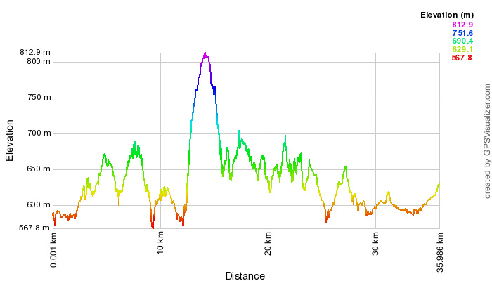
mtb-1-profile.png


<Previous | Next>                             Back to Contents
View full article »

Leg 5 – 37km Mountain Bike

By Prachar Stegemann
10 November

NOTE: THERE HAVE BEEN A FEW CHANGES TO THIS COURSE FOR 2024. CHANGES APPEAR BELOW IN BOLD. View these changes in this video.

View and download the full course on Garmin Connect. Enjoy a GoPro tour of the entire course, as ridden by Andrew Öberg in 2023.

The second mountain bike ride starts at Henry Rolland Park, off Barrine Dr, Acton, and follows the cycle path west. Continue on this path straight across Acton Peninsula and Black Mountain Peninsula. At Acacia Inlet (after the rowing jetty), turn right onto the cycle path leading to Belconnen, across Lady Denman Dr (watch for traffic) and underneath Parkes Way and Caswell Dr. 
Turn left off the cycle path onto the equestrian trail under William Hovell Dr, through the gate on the left with the sign, ‘Stock Grazing Within’ (be sure to close this gate again!), and along the trail to the left, alongside the Cork Oak Plantation.


After the Cork Oaks, you will arrive at the National Arboretum carpark. Turn immediately to your right, up Gunbarrel Hill and follow this outer perimeter road (Boundary Rd), past the main Arboretum car parks. You will end up at the bottom of an incline, at a five-way intersection. Cross the new road and over a gate and continue on this diagonal direction, past a little water tank (on your right). You will eventually come to a four way intersection, veer left here and continue slightly uphill. After going under the powerlines, continue for approx 1.5km where you will turn right on a lesser track taking you back under the powerlines, turn right soon after, taking you to a gate leading to Pipe Flat.
 
Follow this road for about 3 kms alongside Molonglo River until the next gate, bringing you to Coppins Crossing Road. There are some works in progress just before Coppins Crossing Road, so you may need to climb an additional gate here. THIS ROAD IS NOW MUCH BUSIER THAN IN PREVIOUS YEARS – TAKE GREAT CARE AS YOU CROSS DIRECTLY OVER THE ROAD TO THE GATE LEADING TO A DIRT ROAD ON THE OTHER SIDE.
 
Continue straight ahead, veering to the left towards Butters Bridge. After crossing Butters Bridge, turn right onto the gravel path. Soon after, at the 4-way intersection, continue straight ahead down the incline, looking out for a gate on your left. Climb this gate and follow this track uphill until you return to the 2023 course, towards Denman Prospect. Take the next left onto a new emerging road and turn right onto a cycle path that runs parallel to Holborow Ave. Follow this path all the way to a set of traffic lights prior to a bridge. Cross over at these lights and continue straight for approx 200m, towards and past the shops (which are on your left) on a shared path. After the carpark to the shops, on your right, you will see a concrete causeway down the grass slope. This is to be the crossing point to the other side. It has a zig zag in it, so proceed with care. Head uphill towards the powerlines, turn right at the road and then an immediate left onto a lesser trail, heading uphill following the route of the powerlines. Follow this trail for approx 1km (you will have to climb over a gate) until you emerge at a T-junction and the old alignment. Turn left here taking you to a gate and onto Uriarra Rd.

Cross over and go right for about 50 metres, then left through the gate on the other side, into the Mt Stromlo precinct.
 
After crossing Uriarra Rd, follow the North South Link Fire Trail uphill until you reach a T-junction with Forrest Trail. Turn right here, heading now down a little, then starting to rise again until you reach a 4-way intersection where you turn left, then almost immediately right, dipping slightly then heading up onto the shoulder of the mountain. This trail flattens and follows the contour around the western side of the mountain before starting to rise again. At a fork in the trail, turn left to head sharply uphill towards the magnificent summit. At the crest of this steep climb, round a white metal gate and continue straight onto the bitumen road, past some observatory buildings on your right. Now join the main Mt Stromlo Rd and pass by the main observatory settlement. Look out for a hairpin left hand turn off the bitumen, back onto a descending fire trail. This in turn takes a hairpin right hand turn to descend further, past the Blue Gums on your left. After a short rise, take the LEFT hand fork on ‘Ridge Trail’ and continue downhill for approx. 340m before turning left at a sweeping left hand bend on the main road. Continue down this road for approx. 420m, till you reach a spacious 4-way intersection. Turn right here, heading slightly down, until you reach the bitumen road – LOOK OUT FOR THE SHUTTLE BUS AND IF IT APPEARS, PLEASE GIVE WAY! – Then, continue straight across onto the cycle path. Follow the cycle path towards and past the ACT Bushfire memorial turning right just near the entrance to the memorial and onto a small gravel path. Turn left soon after on the second single track to your left, which will take you to Cotter Rd.Cross Cotter Rd, GIVING WAY to ALL TRAFFIC, heading for the grassed right-hand side of Eucumbene Dr, where the single track can be found, to follow the right hand side of Eucumbene Dr.

Look for a right hand turn through the stile to join the track heading to the left up Narrabundah Hill. Take the first fork to your right, pass through or climb the gate on the way up, then take the next fork to your left, heading up. After passing the trig point on your right, continue straight down a long hill, ignoring the potential turn-off to your right, but going straight over another gate. Turn left onto a single track about two thirds of the way down this hill. This track will bring you around beside the large water storage tank. Continue straight ahead, through the stile gap, and right again adjacent to Eucumbene Dr. Follow this track past the end of Hindmarsh Dr, and up the other side (on a left diagonal), around the side of the new bus bay. This track (which is the Centenary Trail) veers to the left, and you continue following the fenceline around to your right, then beside Kathner St. At the intersection of Kathner St and Percy Cres, go straight onto and up the steep track leading to Cooleman Ridge.
 
Go left at the top, and proceed along Cooleman Ridge, behind Chapman. Continue all the way along Cooleman Ridge until you see a large tree at 11 o'clock. Veer left at the fork here, heading down towards the road.  Go through the gate and turn right on the cycle path.  Look out for the arrows to turn left off this cycle path, across the grass and over Namatjira Dr, taking extreme care of the 2-way traffic on this busy road, remembering that you MUST GIVE WAY TO ALL TRAFFIC.  Follow the dirt track on the other side, veering left through the gate, then ultimately turning left at the next cycle path, following this cycle path to the changeover point beside Badimara St.


mtb-2-profile.png

<Previous | Next> Back to Contents

View full article »
  • ‹ previous
  • 21 of 34
  • next ›
More articles under Sri Chinmoy Marathon Team articles »

Sri Chinmoy Marathon Team articles

main page »

Stories from around the world

United States
3, 6 and 10 Day Race 2025
3100 Mile Race
3100 Mile Race - Past and Present
3100 Mile Race
2024 Final Results of 3100 Mile Race
3100 Mile Race
Sri Chinmoy 3100 mile race. The first 10 days.
Worldwide
Start of 3100 Mile Race 2024
Worldwide
Dipali Cunningham Inducted into AUTRA Hall of Fame

About us

  • About the Marathon Team
  • Sri Chinmoy, Team Founder

Our races

  • View all events

Results

  • Previous races
  • Worldwide results
Global homepage »

Country Websites

  • W.Europe
    • Austria
    • Finland
    • France
    • Germany
    • Great Britain
    • Iceland
    • Ireland
    • Italy
    • Netherlands
    • Norway
    • Portugal
    • Switzerland
  • Central & E. Europe
    • Belarus
    • Bulgaria
    • Croatia
    • Czech Republic
    • Hungary
    • Latvia
    • Macedonia
    • Moldova
    • Russia
    • Serbia
    • Slovenia
    • Slovakia
    • Ukraine
  • N. & S. America
    • Brazil
    • Canada
    • Guatemala
    • United States
  • Asia
    • Japan
    • Mongolia
  • Oceania
    • Australia
    • New Zealand

Other sites

  • Sri Chinmoy Cycling Team
  • SCMT Channel Swimming
  • SCMT Climbing
  • 3100 Mile Race

Popular Pages

  • 3100 Mile Race
  • Recent media coverage
  • History 1977-Present
  • Our members
  • Log in

Contact Information

Sri Chinmoy Marathon Team
Brisbane • 87 Pembroke Rd Coorparoo QLD 4151 • 0450 765 315 • Email us
Canberra • Shop G, 1B Dickson Chambers, Dickson ACT 2602 • +61 404 071 327 • Email us
Melbourne • PO Box 3247 Cotham VIC 3101 • 0407 333 740 • Email us
Sydney • Shop G, 1B Dickson Chambers, Dickson ACT 2602 • +61 404 071 327 • Email us
Creative Commons License

Except where explicitly stated otherwise, the contents of this site are licensed under a Creative Commons Attribution-NonCommercial-NoDerivs 3.0 Unported License read more »

SriChinmoyRaces.org is a Vasudeva Server project.