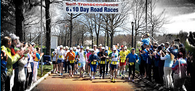
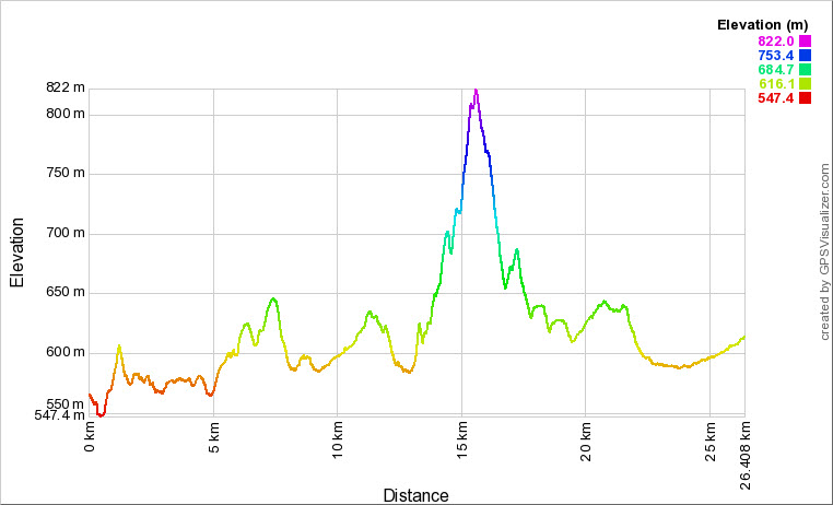
Leg 3: Kirkpatrick St, Weston (next to RSPCA) to Cnr Majura & Phillip Ave, Dickson, 26.4 km
Download complete navigable leg 3 course map, and leg 3 gpx file.
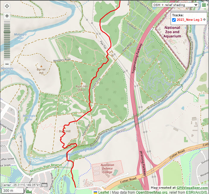
The start point for Leg 3 is on the fire trail opposite the end of Kirkpatrick St, Weston, 20m N of the intersection of the dirt road and bike path.
Head N along the road from CP2 and after 110m veer right off the road to follow a dirt path next to a wire fence. This turns to bitumen after 120m. After another 100m make sure that you turn left between the pine trees (just before the path swings right) to head down a rutty single track to a small bridge after 50m. Veer right from the bridge to keep heading right across a larger bridge crossing the Molonglo River.
270m later (at the first 4-way road junction) you will turn left off the road to take a small MTB single track heading uphill into the pines. After 240m you will exit the MTB track and turn left onto a dirt road, which you will follow for 40m to where it merges with another road. Here you will leave the road, turning right to head up the single track that takes you up to the summit of Bold Hill, marked by two yellow posts and a sign marked “The Luxury of Time”. Exit the summit at approx. 2 o'clock heading to take a faint single track, which takes you down towards a green smokestack pipe, where you then join a gravel road heading towards the main pine forest. Continue straight ahead on this road for 320m until it brings you to a major 4-way road intersection (about 1.71K elapsed). Continue straight ahead for only 30m at this intersection before you turn left to take a MTB single track heading into the forest. Follow the marker tapes and the MTB track for approx. 800 m as it heads N to NE through the pines, running parallel with Forest Drive before swinging left to the NW to bring you out at Boundary Road (approx. 2.56K elapsed).
Turn right onto Boundary Rd and only 40m later (2.60k) turn left through the gate onto Pipe Flat Rd and then only another 40m later turn right to take the grassy track that heads NE under the large powerlines, and then becomes a dirt road heading NW. Stay on this major dirt road (which runs parallel to Boundary Rd and winds around the base of the Arboretum) for approximately 2K, following the marking ribbons.
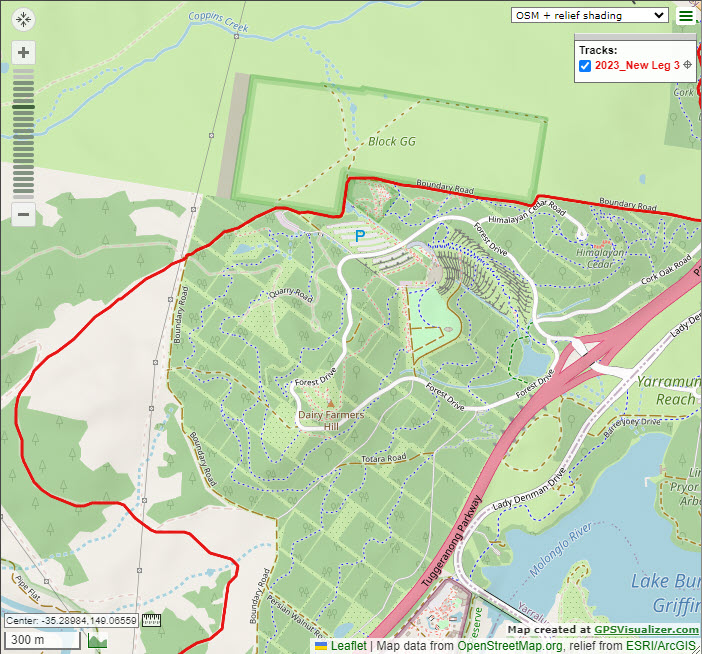
At the end of this road turn right (approx. 5.06K) to head uphill on the Arboretum Emergency Access Track (green signs).
This brings you out at Boundary Rd (5.80K approx.) which you will cross (between yellow pole and the wire fence) and continue straight ahead up the hill towards Telstra Tower in the distance. Pass through the gate at the Works Compound (6.23K) and head left 80m later at the Emergency assembly point sign to follow the fence line. You will now follow this Boundary track which turns left downhill (N) past a Dam (6.32K) and then right (E) to commence a steady climb of about 700m up to the Cnr of Boundary & Himalayan Cedars Rd (7.35K). Turn left at the gate (7.37K) to keep following the dirt road which turns right (E) to head steeply downhill with great views of Lake Burley Griffin in front of you.
At the bottom of the hill turn left at the car park (8.06K) to enter the Cork Oaks Forest path. 60m later bear left onto the main single track which takes you to the entry of the Cork Oaks Plantation (8.35K) where you continue straight ahead on the Bicentennial Trail. At the end of this track (8.87K) turn right onto the path which goes down to the underpass. After 110m (8.98K) turn right at the T-junction to take the bike path heading towards Telstra Tower. After 250m turn left (at Bicentennial Trail sign, about 9.22K) to leave the bike path and cross the pedestrian stile leading into Aranda Snow Gums Reserve. Follow this single-track walking path (black arrows on white signposts) for approx. 600m before turning right (9.83K) to cross the watercourse to head NW up to a grassy area, through a gate (9.97K) and continue on track heading NE for approx. 300m until it brings you up to a gate (approx. 10.3K) where you will turn right onto the fire trail and continue heading NE on Finneran’s Road. for 600m until you reach a T-junction next to Caswell Drive. Turn right and after only 60m turn left to head under Caswell Drive.
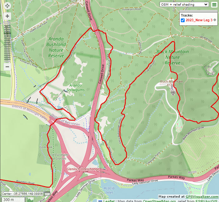
As soon as you pass under the second part of Caswell Drive (approx. 10.98K) make sure that you leave the main fire trail by bearing right to take the single track that shortcuts the corner from Finneran’s Rd across to the Lower Woodland Track.
Turn right (11.1K) to follow the Lower Woodland Track as it heads south back down towards Lake Burley Griffin, running parallel to Caswell Drive for a few kilometres, during which you will encounter the first drinks station before swinging left (E), now called the Upper Woodland Track (12.95K) and climbing gradually for 160m and then swinging left again (N) to climb a very steep short pitch. Continue along this Upper Woodland Track, always taking the most upper right hand (uphill) options at the next two forks in the track (at approx. 14.0K and 14.6K), eventually turning right when you hit the intersection with the main Black Mountain Summit walking track (approx. 14.9K). Climb steeply up the track for several hundred metres, heading straight across the Summit Trail, and continue uphill on the cement path, being sure higher up (approx. 15.3K) to follow it to the left rather than take the dirt track to the summit. The cement track heads around the E side of the mountain and climbs up some steps to meet Black Mountain Drive near Telstra Tower (15.49K). Turn left and stick to the LHS of the road for only 70m or so before turning left to take the steps down a ST walking path (enjoy the amazing views of the Lake and Canberra City) for approx. 350m where you will head straight ahead into a car park (15.92K). Follow the LHS of the car park and at its end (15.97K) turn left towards the lookout and 30m later turn right (16.00) to take the single-track heading SE and then E downhill. After approx. 500m distance of steep, rocky descent (16.54k) turn left to take the Botanical Gardens Trail, which undulates along the East side of Black Mountain. This finally (17.15K) starts descending to a gate (17.34K) and 80m later veers left downhill to merge with a large dirt road (Frith Rd).
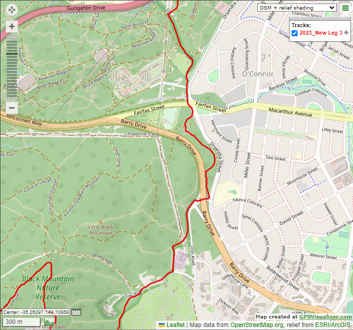
Turn right onto Frith Rd (17.43K) and head downhill for approx. 300m before turning left (17.73K) at the BNT sign to join and follow the dirt road that climbs up alongside the west side of the electricity substation. Approx. 200m after the substation (17.92K) take care to veer off the road to the right to follow the earth bank, following the BNT single track that runs under the powerlines. After approx. 300m the BNT drops off the embankment to the right to descend to Frith Rd. Cross straight across the road and over the low guard rail and then turn left (18.40K) to head through the Barry Dr. underpass on the LHS. After exiting the underpass, turn hard left at the BNT/Stop sign (18.47K) to take the BNT single track heading uphill into the trees. Follow the BNT track all the way through to the roundabout at Fairfax St/Dryandra St where a Course Marshal (2nd drinks station) will aid with crossing (19.38K).
Continue straight across Fairfax St heading N to join a bike path and follow this for 600m up a gentle climb before making sure that you make a hard right turn (20.14K) under the big powerlines to enter the O’Connor Ridge trails.
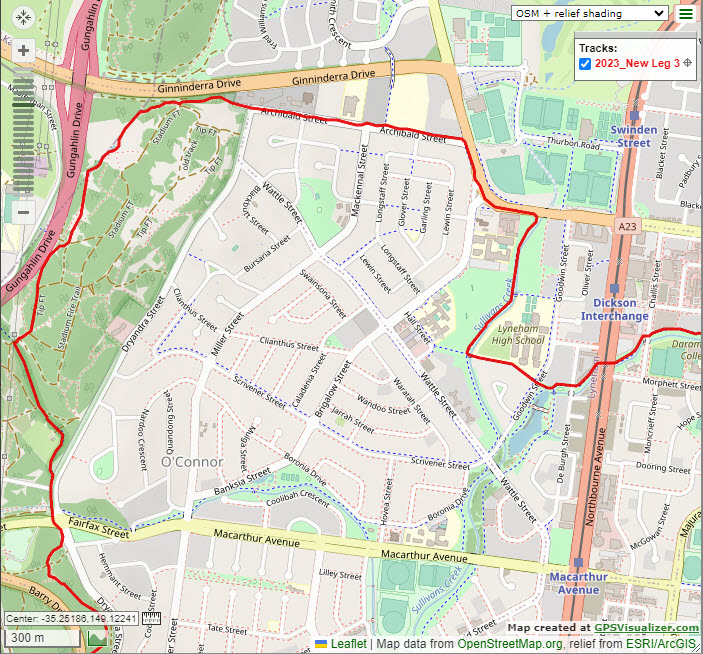
After about 100m make sure that you take the main track heading off to the left that climbs up to, and runs very close and parallel to Gungahlin Drive, not taking any trail options to your right (20.4K). After another 200m or so of track near the fence line, leave the fence line (20.59K) track at an approx. 2 o'clock heading and reach a 4 way track intersection (20.62K) where you will veer slight left to continue N on the main fire trail parallel to Gungahlin Drive. After 70m (20.69K) stay on the main track (left option) but at the next track split about 200m later (20.92) take the right single track into the trees, which you takes past the RHS of a small dam (21.05K), continuing straight ahead on the ST across the wooden planks (21.07K). Less than 200m later (21.25K) take the right, larger single track at the split which heads through the wattle trees and eventually swings further right to run along the RHS of a wire fence. Turn left through the gate (21.41K) and turn right to head E down the dirt road between Ginninderra Drive on your left and the powerlines, which 250m later passes a church and becomes Archibald St. Stay on the grass verge/footpath on the LHS of Archibald St for the next 840m (passing various churches, monasteries and Buddhist Temples) until it dead-ends at a T-junction with Mouat St. Turn right to cross Archibald St (22.51K, course marshal) and join the bike path, being careful after 180m to leave this path, turning left to cross the bitumen dead end and head to the pedestrian crossing/lights at Brigalow St (22.77K; Course Marshal). After crossing continue left on the footpath (22.79K) past the Lyneham Motor Inn (22.91K) and 90 m later turn right (23.00K) onto the bitumen bike path that runs along the RHS of the water canal. Follow this path for approx 650m before turning left at the end of the playing fields (Follow signs to Dickson Shops 2K) to cross the bridge across the canal and join another bike path heading towards Lyneham High School. Take care crossing Goodwin St (23.92K) at the speed hump/ped. crossing. After 50m merge left to take the bike path towards Dickson shops (blue and white sign). Cross DeBurgh St at the pedestrian crossing. (24.07K)
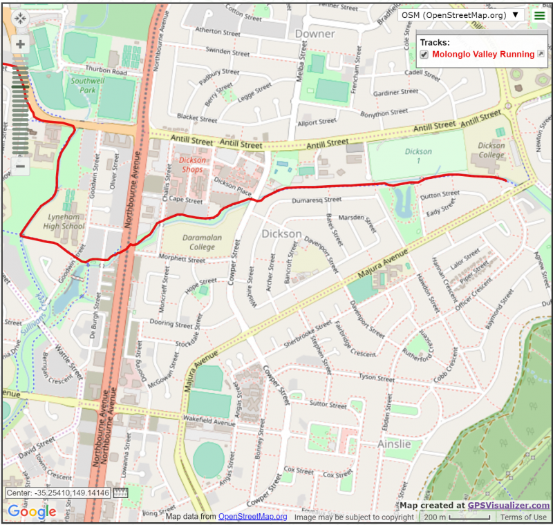
***Likely Scenario 1: Head Under Northbourne Ave
At this point, if the conditions are favourable, you will divert right across the grass to drop into the canal at a metal ladder just before Northbourne Ave (marker cones or arrows) in order to run under the two arms of the very busy Northbourne Ave and then exit the canal to the left at another metal ladder soon after the other side to re-join the bike path.***
Scenario 2: Cross Northbourne Ave at pedestrian crossing lights
If conditions do not favour use of the canal (heavy rain prior to race) you will have to continue straight ahead on the bike path to cross Northbourne Ave (24.22K) at the lights and pedestrian crossing to continue along the bike path to Dickson (24.26K).
Continue along the bike path to cross Challis St (24.45K) at the pedestrian crossing and then take after another 500m take care to cross Cowper St (24.95K) at the pedestrian crossing at the traffic lights. Continue straight onto the bike path (24.97K) that runs between the canal and the houses and follow (without turns) this for approx. the next 1.3K to finish at the 3rd (final) transition area where the powerlines cross the bike path (telephone pole with red tag 37387) in the grassy area on the west side of Majura Ave (26.24K) .