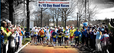


Sri Chinmoy Canberra Trail Series
A 5-race series at popular venues close to Canberra for your enjoyment, fitness and self-transcendence
Upcoming races
About the event
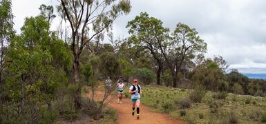
The Sri Chinmoy Marathon Team offers a series of Winter trail runs at popular venues close to Canberra for your enjoyment, fitness and self-transcendence. Each event includes races of 3 distances:
* Short (2km – 3.6km)
* Middle (5km – 10.6km)
* Longer (9.6km – 21.1km)
The dates and venues for 2026:
Race 1: Sunday 26 April, "Cooleman Clip" – 2km, 5km, 9.6km
Race 2: Sunday 10 May, "Tidbinbilla Thriller" – 3.4km, 6.8km, 11.8km
Race 3: Monday 1 June, "Red Hill Ramble" – 2.4km. 8km, 12.8km
Race 4: Sunday 28 June, "Ainslie Amble" – 2km, 8.3km, 15km
Race 5: Sunday 19 July, "Aranda Meander" – 3.6km, 10.6km, 21.1km
All races start from 10am.
To enter online – for new registrations only, click the link below.
For existing Series entrants – please click the "Edit my registration" button contained in the email sent to you after you entered your first event of the Series.
Earlybird entries close at 5pm, 2 days prior to the race date. Entries received after this time (including on the day entrants) pay the 'late' entry fee (see rates on right of page).
For on-the-day entries, please bring your smartphone to enter online on site and remember to bring your permanent Sri Chinmoy race number bib if you have one!
Sorry, no dogs – because several of the Series courses are wholly or partially in "no dogs" areas of Canberra's Nature Parks and Reserves, for consistency and to avoid confusion, participants may not be accompanied by their dogs in any of the races of the Series.
Introducing the Sri Chinmoy Canberra Trail Series
Welcome to the Sri Chinmoy Canberra Trail Series!
Events
Short Distance (2km – 3.6km)
-
- 10am
-
- per race $13 online, + $5 one-off race bib fee
- Earlybird entry closes at 5pm, 2 days prior to the race date
- 'Late' entry $20
Middle Distance (5km – 10.6km)
-
- 10am
-
- per race $27 online, + $5 one-off race bib fee
- Earlybird entry closes at 5pm, 2 days prior to the race date
- 'Late' entry $40
Longer Distance (9.6km – 21km)
-
- 10am
-
- per race $31 online, + $5 one-off race bib fee
- Earlybird entry closes at 5pm, 2 days prior to the race date
- 'Late' entry $47
Contact
Prachar Stegemann 0404 071 327
 Send Email
Award categories
- Medals 1st 7 places Under 50; 1st 3 50-59; 1st 2 60-69; 1st 70+ (M & F) (Longer & Middle Distance)
- Medals 1st 3 places Under 13; Under 17; 17 and Over (M & F) (Short Distance)
- Trophies for 1st 3 places in the Series Pointscore Championship
Upcoming Races
Race 1: 26 April"Cooleman Clip" 2.2km, 5km & 9.6km
The Series starts with the "Cooleman Clip", a southside adventure, exploring the wonderful tracks and trails along either side of Cooleman Ridge.
The start and finish is on Chapman Oval. Park on Tauchert St, Chapman, or along Streeton Dr. On-the-day registration opens at 9 a.m. and closes at 9.45 a.m., with races starting from 10 a.m.
View the route map for the 2.2km course (2 laps of the 1.1km loop), and its elevation profile, or download the 1.1km loop gpx file; view the route maps for the 5km course – 5km part 1, 5km part 2, 5km part 3 – and 5km elevation profile or download the 5km gpx file; view the route maps for the 10km course – 10km part 1, 10km part 2, 10km part 3, 10km part 4, and 10km elevation profile or download the 10km gpx file.
Read the full course description and take a photo tour of the courses.
 Race 2: 10 May
"Tidbinbilla Thriller" 3.4km, 6.8km & 11.8km
The "Tidbinbilla Thriller" ventures south into the delightful Tidbinbilla Nature Reserve. You will feel you are completely out in the bush, though only 20 minute's drive from Tuggeranong. If you are contemplating tackling the Long Course, be warned! – 11.8km may sound easy enough, but there very steep, long and rocky ascent, combined with the even steeper descent from Gibraltar Peak saddle, make this a very challenging outing. Please wear shoes with a strong grip! The middle distance 6.8km ranks as a very decent morning's run, while the gentler 3.4km shorter loop is an ideal foray to familiarise yourself with this idyllic setting.
Park Entrance Fee – a Tidbinbilla Nature Park Day Pass (payable per vehicle) can be obtained online in advance (you will need to print it to display on your windshield), or by scanning a QR code at the Visitor Information Centre at the entrance to the Park.
The start/finish area is Webbs Picnic Area, the furthest from the Park entrance.
Pin location of Webbs Picnic Area.
Webbs Picnic Area does not appear on Google maps – NAVIGATE YOUR WAY TO THE VISITOR INFORMATION CENTRE, AND FOLLOW THE SIGNAGE TO THE START/FINISH, or use the pin above.
Parking – there is limited parking available at the start/finish area at Webbs Picnic Area. Please utilise the parking lots at Sheedys, Blewetts and Greens Picnic Areas and allow more time to walk/jog to the start.
No phone coverage – there is no mobile phone coverage for most carriers at Webbs Picnic Area or in the surrounds.
On-the-day registration opens at 9 a.m. and closes at 9.45 a.m., with races starting from 10 a.m.
BATHROOMS Note there are no toilets at Webbs Picnic Area – so please make use of the toilets at the Visitor Information Centre at the entrance to the Park, or at Sheedys or Greens Picnic Areas, which you pass on the way to the start at Webbs Picnic Area.
View the route map and elevation profile or download the gpx file for the 3.4km course; view the route map and elevation profile or download the gpx file for the 6.8km course; view the route map and elevation profile or download the gpx file for the 11.8km course.
Read the full course description and take a photo tour of each of the courses.
To enter online – for new registrations only, click the link below.
For existing Series entrants – please click the "Edit my registration" button contained in the email sent to you after you entered your first event of the Series.
 Race 3: 1 June
"Red Hill Ramble" 2.4km, 8km & 12.8km
NOTE THIS RACE IS HELD ON MONDAY 1 JUNE IN 2026, RECONCILIATION DAY IN THE ACT
Overlooking Parliament House and Lake Burley Griffin on one side, and Woden Valley on the other, the "Red Hill Ramble" could not be closer to the beating heart of the Nation. Featuring some of the most walked of Canberra's trails, Red Hill and its flora and fauna have been the sanctuary and inspiration for countless Canberrans. There 3 course offer a balanced blend of wide fire trails with walking and single tracks of varying gradients. Difficulty rating: mild.
The start/finish area is alongside the Scouts Branch Office, 89 Kitchener St, Garran.
Parking – there is limited parking available at the start/finish area. Please find a park along any of the neighbourhood streets and allow time to walk/jog to the start.
On-the-day registration opens at 9 a.m. and closes at 9.45 a.m., with races starting from 10 a.m.
View the route map and elevation profile or download the gpx file for the 2.4km course; view the route map and elevation profile or download the gpx file for the 8km course; view the route map and elevation profile or download the gpx file for the 12.8km course.
Read the full course description and take a photo tour of each of the courses.
To enter online – for new registrations only, click the link below.
For existing Series entrants – please click the "Edit my registration" button contained in the email sent to you after you entered your first event of the Series.
 Race 4: 28 June
"Ainslie Amble" 2km, 8.3km & 15km
The "Ainslie Amble" explores some of the oldest and most loved trails in Canberra, around the base of Mt Ainslie, along with more recent single tracks on Mt Ainslie and Mt Majura. The novice 2km race follows the houses behind Duffy St, Ainslie, while the middle distance 8.3km route wanders up and around the saddle of Mt Majura. The longer 15km race is a testing yet thoroughly enjoyable outing, adding a full loop of Mt Ainslie, including a gut-busting ascent of the southern face and sections of the Centenary Trail.
The start/finish area is alongside the corner of Kellaway St and Phillip Ave, Hackett. On-the-day registration opens at 9 a.m. and closes at 9.45 a.m., with races starting from 10 a.m.
BATHROOMS for this event will be open at Hackett Oval, about 100 metres from the start/finish area.
View the route map for the 2km course; view the route map, satellite view and elevation profile or download the gpx file for the 8.3km course; view the route map and elevation profile or download the gpx file for the 15km course. View the start/finish area.
Read the full course description and take a photo tour of each of the courses.
 Race 5: 19 July
"Aranda Meander" 3.6km, 10.6km & 21.1km
Aranda Bushland and the adjoining Black Mountain Reserve sit between Canberra's CBD, the Australian National University, the CSIRO and Lake Burley Griffin on one side, and the suburban region of Belconnen, Canberra's largest residential conglomerate, on the other. No area of Canberra has a denser or more varied network of walking, biking, hiking and running tracks and trails, or a more fascinating array of habitats, flora and fauna – all right in the thick of the nation's capital.
The start/finish area is Aranda Oval, off Banambila St, Aranda.
Parking – is available at Aranda Oval and adjoining streets.
On-the-day registration opens at 9 a.m. and closes at 9.45 a.m., with races starting from 10 a.m.
View the route map and elevation profile or download the gpx file for the 3.6km course; view the route map and elevation profile or download the gpx file for the 10km course; view the route map and elevation profile or download the gpx file for the 20km course.
Read the full course description and take a photo tour of each of the courses.
To enter online – for new registrations only, click the link below.
For existing Series entrants – please click the "Edit my registration" button contained in the email sent to you after you entered your first event of the Series.
The Courses
- "Cooleman Clip" 2.2km, 5km
- "Cooleman Clip" 10km
- "Cotter Canter" 5km & 10km
- "Stromlo Strides" 2km, 6.3km
- "Stromlo Strides" 15.4km
- "Ainslie Amble" 2km & 8.3km
- "Ainslie Amble" 15km
- "Tuggeranong Trot" 2km & 8km
- "Tuggeranong Trot" 20km
- "Gungahlin Gallop" 2.2km, 10km
- "Gungahlin Gallop" 31km
- "Tidbinbilla Thriller"
- "Red Hill Ramble"
- "Aranda Meander"
Download the 2.2km gpx file; view the 2.2km course map (2 loops of the 1.1km route) and 1.1km loop elevation profile; download the 5km gpx file; view the 5km course maps – 5km part 1, 5km part 2, 5km part 3 and 5km elevation profile.
Take a photo tour of the courses.
Introduction
Cooleman Ridge is one of the most used and loved areas around Canberra for runners, walkers, bikers and horse riders. Many have chosen to settle in Weston Creek primarily to enjoy proximity to the wonderful network of equestrian trails, fire trails, management trails, walking and single tracks that wend their way up, down, around and along both sides of this humble yet magnificent ridge.
Affording views to the north across the whole of urban Weston Creek, the Woden Valley and South Canberra over Lake Burley Griffin to Black Mountain and beyond; to the south towards Mt Tennant; and to the west over the Murrumbidgee River to the Bullen Range and the mighty beckoning Brindabellas, few vantage areas offer a fuller panoply of Canberra's rare wealth of natural blessings and beauty.
2.2km Novice Course
The start and finish is on Chapman Oval. Park on Tauchert St, Champman, or along Streeton Dr.
The Start is near a small cement circle, on Chapman Oval, in front of the west end of the facilities block. From here, head away from the amenities block towards Streeton Dr, staying outside the cones set up around the perimeter of the oval. Join with the pedestrian path heading west, alongside the fence of Chapman Primary School. Turn left to continue alongside this fence and follow the concrete path uphill until you come to an underpass. Do not proceed through this underpass, instead turning to your left and proceed on the pedestrian path along in front of the Primary School, then down the grassy bank to return to your starting point. Repeat this 1.1km loop, for your full 2.2km course.
5km course
(split distances are approximate)
The start and finish is on Chapman Oval. Park on Tauchert St, Champman, or along Streeton Dr.The Start is near a small cement circle, on Chapman Oval, in front of the west end of the facilities block. From here, head west across the oval aiming for the right hand side of the baseball practice net and head up the grassy hill between the trees to join a cement driveway, which leads you up to a footpath (200m elapsed) where you will turn right at some yellow poles to head along the front of Chapman Primary School. After approx. 200m (0.4K) turn sharp left to head through the underpass under Perry Drive and continue straight uphill, taking care after 80m to take the right hand path which heads steeply uphill with the houses on your right. At the top of the stairs (approx. 0.74K) take the small single track uphill near the fence and houses on your right for approx. 90m, when it merges with a firetrail heading uphill (0.83K).
After 130m you will reach a T-junction: turn right onto Cutoff Drain FT (0.96K) and follow this as it heads west behind the houses for about 700m before making a sharp left turn onto Darrell Place FT (1.7K). After 80m continue straight ahead at the 4 way track junction but 40m later take the left track at the burnt log (heading away from water tower) to start descending to the other side of the Ridge. Climb through the gate (1.95K) and 40m later turn left to join the Cooleman Ridge BNT heading southwest (1.99K). Follow this for 640m until you reach a corner where you will turn left (2.63K) to take the Little Reservoir FT back uphill for approx. 500m to reach the water reservoir (3.16K). After about 70m you will join the main FT heading downhill (3.23K) and 110 m later turn right onto Arawang Saddle FT (3.34K) and then immediately left (20m later; 3.36K) to take the small FT which takes you back down to the Cutoff Drain FT near the houses (3.49K) where you will turn left to head north. Follow this for just over 300m (3.80K) to reach the hairpin corner where you originally joined the Ridge, and turn right, downhill to retrace the same route (in reverse) as the first kilometre, with you finishing by running down the grassy bank at Chapman Oval to reach the Finish at approx. 4.8K.
Download the 10km gpx file; view the 10km course maps – 10km part 1, 10km part 2, 10km part 3, 10km part 4 and 10km elevation profile.
Take a photo tour of the courses.
Introduction
Cooleman Ridge is one of the most used and loved areas around Canberra for runners, walkers, bikers and horse riders. Many have chosen to settle in Weston Creek primarily to enjoy proximity to the wonderful network of equestrian trails, fire trails, management trails, walking and single tracks that wend their way up, down, around and along both sides of this humble yet magnificent ridge.
Affording views to the north across the whole of urban Weston Creek, the Woden Valley and South Canberra over Lake Burley Griffin to Black Mountain and beyond; to the south towards Mt Tennant; and to the west over the Murrumbidgee River to the Bullen Range and the mighty beckoning Brindabellas, few vantage areas offer a fuller panoply of Canberra's rare wealth of natural blessings and beauty.
10km course
(split distances are approximate)
The start and finish is on Chapman Oval. Park on Tauchert St, Chapman, or along Streeton Dr.
The Start is near a small cement circle, on Chapman Oval, in front of the west end of the pavilion. From here, head west across the oval aiming for the right hand side of the baseball practice net and head up the grassy hill between the trees to join a cement driveway, which leads you up to a footpath (200m elapsed) where you will turn right at some yellow poles to head along the front of Chapman Primary School. After approx. 200m (0.4K) turn sharp left to head through the underpass under Perry Drive and continue straight uphill, taking care after 80m to take the right hand path which heads steeply uphill with the houses on your right. At the top of the stairs (approx. 0.74K) take the small single track uphill near the fence and houses on your right for approx. 90m, when it merges with a firetrail heading uphill (0.83K).
After 130m you will reach a T-junction: turn right onto Cutoff Drain FT (0.96K) and follow this for approx. 1.4k as it heads west and north west behind the houses. Make a sharp left turn across the footbridge (2.59K) to climb steeply up the stairs to just before the Cooleman Trig (2.72K) where you will turn right onto the single track for 30m before climbing through a gate (2.75K) that sends you downhill from the summit (SW) for 90m until you reach a T-junction at which you will turn left (2.84K, SE) onto the Nature FT (no sign). This track descends to a saddle and an intersection with Dam FT at 3.01K, at which point you continue straight ahead, along the ridgeline. Follow this scenic single track for approx. 700m, descending to a 4 way intersection at the big water tank (3.70K) at which point you will continue straight ahead, along the ridgeline.
Follow this as it starts to climb gradually, then steeply, up to another little water reservoir (4.42K), and 50 m later to a T-junction where you will turn left (4.47K), downhill onto a major fire trail. After only 100m make a right turn (4.57K) onto the Arawang Saddle FT, which take you SW along the ridgeline towards Mt Arawang. From this point, stay on the main ridgeline and ignore the two left minor trails at 4.79K and at 5.00K that head towards Mt Arawang. At the 5K point you will start to head south, downhill, on a moderately steep descent for 250m (5.25K) before turning sharp left (towards Mt Arawang) along a lovely piece of single track. This track contours, then gradually descends, and after approx. 300m (5.57K) merges with the main track descending from the west side of Mt Arawang saddle. After 50 m (5.62K) you reach the bottom T- junction and turn left onto Cutoff Drain FT.
Stay on this FT for the next 1.5 K, doing an anticlockwise circuit of the base of Mt Arawang. Once you are on its north side be on the lookout for a ParkCare noticeboard on your left (7.07K), 40m after which (7.11K) you will turn left, cross through a small ditch and onto an indistinct single track to climb the steep, rocky single track to the Mt Arawang summit trig (7.41K). Only 10m past the summit (7.42) take the single track to the right that descends to the west, with quite a few steps, down to a 4 way track intersection at the Mt Arawang saddle. Turn right (7.79K) and head down the steps for 110m to reach the Cutoff Drain FT (7.90K). Turn left and follow this FT for just over 800m until you reach the hairpin corner where you originally joined the Ridge, and turn right (8.74K), heading downhill to retrace the same route (in reverse) as the first kilometre, with you finishing by running down the grassy bank at Chapman Oval to reach the Finish at approx. 9.8K.
View the course maps for the Novice course in satellite view or map view, and for the 5km course in satellite view or map view (10km = 2 laps of the 5km course). Take a photo tour of the course.
Introduction
The Cotter is an iconic recreation area loved by Canberrans, being only 23km from the city centre but offering a beautiful setting framed by the Cotter and Paddys Rivers and the impressive new Cotter Dam wall. The area is ideal for picnics, swimming, fishing, bushwalking and relaxation and is the perfect venue to host the first event of the Sri Chinmoy Canberra Trail Series.
The Cotter Bend, where the Paddys River meets the Cotter River, is a favourite with many for a swim, splash and for fishing. A wide pool and sandy beach marks the meeting of the two rivers. Paddys River has its genesis at Mount Tennent beyond Tharwa in Namadgi National Park and its fresh clean waters complement the Cotter as they come together at the 'Bend'.
The start/finish area for this event at Cotter Bend has plenty of grassy area with shade on sunny days, good toilet facilities and plenty of parking.
The Cotter Canter is our first event and is the ideal introduction to trail running and walking, offering distance options of approximately 5km and 10km for runners and 5km for walkers. That being said, experienced road and trail runners will also get a demanding, but scenic workout on path and trail in this setting and will need to use all of their speed, strength and endurance to post a competitive time.
Novice 2.15km “Path” Loop
The start is at a metal pole at the N end of the grassy area next to Cotter Bend Car Park. After 120m heading S along the grass (0.12) join the path heading W and after another 80m (0.20) cross the bridge and turn right to join the path heading N along the W side of the Cotter River. Follow this path under Cotter Rd (0.67) and after another 60m (0.73) take the upper path on your left which runs next to the Cotter playground on Cotter Avenue. Follow this path (Cotter Dam Discovery Trail) all the way to the bridge across the Cotter (1.10) with an imposing view of the Cotter Dam Wall. Follow the path back along the E side of the river for approximately 400m (keeping right at any junctions) before turning right (1.50) to cross back over to the other side and then left to follow the riverside path back under Cotter Rd (1.65) followed 100m later (1.75) by a left turn down to cross the river again on a small footbridge. After crossing the bridge, follow the path to the right as it winds up a grassy hill and then turns sharp right at the top of the climb (1.92). Soon after turning right at the top of the path climb, the Novice Course turns downhill to the left (down the grassy strip, following the cones) to eventually cross the Car Park (road marshal present) at the swing gate. After descending to the grassy flat, turn right to join the Finish chute through to the Finish line timing mat (2.15K).
5km event: One “Path” Loop followed by One “Trail” Loop
The 5km event consists of two loops:
- An initial clockwise “Path Loop” of approximately 2.3km that follows the Cotter Dam Discovery Trail up to the Cotter Dam wall and back to the start along the two sides of the Cotter River, followed by
- A counter-clockwise “Trail Loop” of approximately 2.8km which follows the Cotter River in the other direction, crosses Paddys River (you will get your shoes and socks wet) and then climbs to follow the Bullen Trail along to Cotter Campground, with a return along the single track path to the finish at Cotter Bend.
At the end of the “Path” Loop you will cross a Lap Timing Mat and at the end of the “Trail Loop” you will cross a separate Finish Timing Mat. These will be well signposted and obvious on the day.
The “Path” Loop
The start is on the grassy area in front of the Cotter Bend Car Park approximately 120m from the path at Cotter Bend. After 120m along the grass (0.12) join the path heading W and after another 80m (0.20) cross the bridge and turn right to join the path heading N along the W side of the Cotter River. Follow this path under Cotter Rd (0.67) and after another 60m (0.73) take the upper path on your left which runs next to the Cotter playground on Cotter Avenue. Follow this path (Cotter Dam Discovery Trail) all the way to the bridge across the Cotter (1.10) with an imposing view of the Cotter Dam Wall. Follow the path back along the E side of the river for approximately 400m (keeping right at any junctions) before turning right (1.50) to cross back over to the other side and then left follow the riverside path back under Cotter Rd (1.65) followed 100m later (1.75) by a left turn down to cross the river again on a small footbridge. After crossing the bridge, follow the path to the right as it winds up a grassy hill and then turns sharp right (1.92) to run parallel to Cotter Bend Car Park heading SW. At the Toilet Block (2.15) turn left to follow the cones back down to the grassy area and approximately 140m later (2.29) turn around the tree to follow the cones over the Lap Timing Mat (2.33) to start your “Trail Loop”.
The “Trail” Loop
The “Trail Loop” starts the same as the “Path Loop” by once again joining the path at Cotter Bend (2.42) but this time when you cross the bridge (2.52) you will turn left at the Course Marshall to follow the cones across the grass. Approx. 100m later you will encounter a small rock scramble and then join a narrow single track next to the river that soon climbs up some steps onto some more narrow single track. This will bring you out at a fire road (2.81) which you will follow for 50m (2.86) before turning left onto another wide fire road heading E. Follow this dirt road for approx. 400m before descending to cross the Paddys River (3.28; ankle to knee deep) and then climb a short, steep pitch for approx. 150m before turning left off the road (3.44) to join some delightful single track (Bullen Trail) which skirts high above the Cotter with views to your left of Cotter Bend and the start/finish area. This scenic track undulates for a while before descending to some sandy trail (4.25km) and 100m later turns sharp left (4.35) to cross a footbridge across the Cotter. After crossing the bridge turn left to follow the grassy bank climbing up to a defined single track and some steps (4.5km) and then descending some more steps to pass a toilet block (4.62). One more climb onto a small fire trail (4.70) and 150m later (4.85) cross the eastern end of the Cotter Bend Car Park and cut through the boulders to join the last final sprint along the grass to the Finish Line Mat (5.11).
10K event: One “Path” Loop, One “Trail” Loop, Repeat “Path” Loop, Repeat “Trail” Loop
Read the detailed instructions for the 5K event outlined above. You will simply repeat the 5km event in the same sequence once again, meaning that you will cross the Lap Timing Mat three times (Lap Splits: Path, Trail, Path) before finishing your second “Trail Loop” at the Finish Timing Mat. The approximate distance of the 10km course is 10.2km.
Download the 2km gpx file; view the 6.3km course map and elevation profile, and download the gpx file.
Take a photo tour of the route (includes the 15.4km course).
Introduction
A phoenix which grew from the ashes of the catastrophic fires of January 2003, Stromlo Forest Park is a superb testimony to the vision and optimism of a Canberra’s leaders of that time. A world-class recreational precinct adjacent to urban Canberra, the Park both inspires and fulfils the tastes and needs of Canberra’s highly skilled, adventurous and discerning athletic public.
Utilising the man-made resources of “Deek’s Track”, the purpose-built cross-country running track alongside numerous equestrian and fire trails exploring the various terrains and ecosystems inhabiting the scenic slopes and summit of Mt Stromlo itself, three courses of varying distance offer a spectrum of personal challenges and enjoyments.
2km Novice Course
The route is one clockwise lap of “Deek’s Track”, starting and finishing in front of the Stromlo Forest Park pavilion. This coure excludes the optional “Hill Loop”, but does include the “Creek Loop”.
6.3km course
The 6.3km race starts with a near-complete clockwise circuit of “Deek’s Track” cross-country running course, including the optional “Hill Loop” (without the furthest little steep hill extension) and the “Creek Loop”.
After about 2km (2.06), just after the track passes a large pond on the right, the route turns L (left) onto a small single track just prior to a culvert, and then veers R (right) after a further 80m to merge with a wider track running parallel with a creek on the L, and around the end of the criterium track on your R.
After 400m (2.54) this track becomes briefly bitumen. Pass around the metal gate, cross a bitumen road and continue onto the main dirt road leading straight ahead and slightly uphill. Pass “The Playground” mountain bike test trails course on your R.
500m along this track (3.05), turn L at a large intersection, then continue straight (avoid the left hand veer) after a further 110m. This trail rises and curves around to the right, gently climbing the hip of Mt Stromlo, before dipping again to reveal the summit directly ahead. Continue on what is now “Ridge Trail”, which climbs briefly and dips again, passing a few cross-roads until after about 1km (4.10) reaching a major intersection with a stand of Blue Gums on the right.
At this juncture, the Long (15.4km) Course continues ahead uphill towards the summit, while the Middle Distance (6.3km) Course turns right and downhill into the Blue Gums. After 200m among the majestic gums, the Long Course track again rejoins from the L. Both courses now follow the same route, downhill out of the Blue Gums, past some picnic tables and then a toilet block on the R, then the original turn-off point on the R.
You are back on the same course as your outbound route, now following it in reverse and downhill, past “The Playground” this time on your L, across the bitumen road, through the metal gate, past the end of the criterium course and along the narrower single track to rejoin “Deek’s Track” cross-country course at the point where you left it. Turn L here and complete “Deek’s Track” clockwise to the finish, opposite the Stromlo Forest Park pavilion.
View the 15.4km course map and elevation profile, and download the gpx file.
Take a photo tour of the route.
Introduction
A phoenix which grew from the ashes of the catastrophic fires of January 2003, Stromlo Forest Park is a superb testimony to the vision and optimism of a Canberra’s leaders of that time. A world-class recreational precinct adjacent to urban Canberra, the Park both inspires and fulfils the tastes and needs of Canberra’s highly skilled, adventurous and discerning athletic public.
Utilising the man-made resources of “Deek’s Track”, the purpose-built cross-country running track alongside numerous equestrian and fire trails exploring the various terrains and ecosystems inhabiting the scenic slopes and summit of Mt Stromlo itself, three courses of varying distance offer a spectrum of personal challenges and enjoyments.
15.4km Course
The 15.4km race commences with a near-complete clockwise circuit of “Deek’s Track” cross-country running course, including the optional “Hill Loop” (without the furthest little steep hill extension) and the “Creek Loop”. After about 2km (2.06), just after the track passes a large pond on the right, the route turns L (left) onto a small single track just prior to a culvert, and then veers R (right) after a further 80m to merge with a wider track running parallel with a creek on the L, and around the end of the criterium track on your R.
After 400m (2.54) this track becomes briefly bitumen. Pass around the metal gate, cross a bitumen road and continue onto the main dirt road leading straight ahead and slightly uphill. Pass “The Playground” mountain bike test trails course on your R.
500m along this track (3.05), turn L at a large intersection, then continue straight (avoid the left hand veer) after a further 110m. This trail rises and curves around to the right, gently climbing the hip of Mt Stromlo, before dipping again to reveal the summit directly ahead. Continue on what is now “Ridge Trail”, which climbs briefly and dips again, passing a few cross-roads until after about 1km reaching a major intersection with a stand of Blue Gums on the right. At this juncture (4.10), the Long (15.4km) Course continues ahead uphill towards the summit, while the Middle Distance (6.3km) Course turns right and downhill into the Blue Gums.
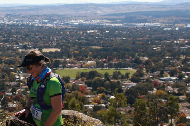
The 15.4km route heads up the front of the mountain, sweeping to the R for 600m before taking a L hairpin turn (4.71) and continuing to rise a further 600m (keeping to the R hand option at a fork just prior to the metal gate) until the bitumen Mt Stromlo Rd is reached (5.32). Turn R onto the verge on the RH side of the road (do NOT run on the road please). After 300m along the road verge, continue onto the lesser bitumen road straight ahead, where the main road turns L in front of the burned-out ruined observatory (water refill possible here at 5.60km).
Pass the Mt Stromlo summit trig on your R (5.88) and the Satellite Laser Ranging Facility on your L. A further 300m along, pass around the metal gate where the bitumen ends, continuing onto the dirt track straight ahead, now heading downhill, staying L at the fork and passing another metal gate (5.96). Extensive views across to the Brindabella Range now open up as you descend steeply for 500m, turning R (6.40) at the T-junction and then L after a further 100m (6.50) now heading down and away from Mt Stromlo.
Descend a further 360m before turning L (6.86) at the next T-junction of Stromlo Pipeline Rd, which bends after a while gently right, then left. 500m further along, turn R at the the gate bearing the sign “Space Weather Monitoring Site”(7.38), then R again after 40m (7.42) onto the Cooper Fire Trail, which curves gracefully along the valley for 1.8km. Watch out for wallabies and rabbits! Take the next available R turn (9.23km, before arriving at the next gate), now heading back uphill towards Mt Stromlo.
Climb this track for 500m, pass through a gate (9.67), cross straight over a 4-way intersection with Stromlo Pipeline Rd, to continue onto the Mountain View Track, climbing for another 500m till you meet and turn L (10.17) at the major T-junction of Forest Trail.
Stay on Forest Trail, ignoring all potential side tracks and trails, as it winds around and along the flank of the mountain for 2.8km.
Forest Trail ends at a T-junction with Ridge Trail(13.05). Turn R here and continue 400m into the Blue Gums, where you will turn L again at the next T-junction (13.45) to rejoin the Middle Distance (6.3km) course.
Run downhill out of the Blue Gums, past some picnic tables and then a toilet block on the R, then the original turn-off point on the R. You are back on the same course as your outbound route, now following it in reverse and downhill, past “The Playground” this time on your L, across the bitumen road, around the metal gate, past the end of the criterium course and along the narrower single track to rejoin “Deek’s Track” cross-country course at the point where you left it. Turn L here and complete “Deek’s Track” clockwise to the finish, opposite the Stromlo Forest Park pavilion.
View the 2km course map; download the 8.3km gpx file; view the 8.3km course map, satellite view and elevation profile, and start/finish area.
Take a photo tour of the courses.
Parking is along the southern end of Phillip Ave, Hackett.
Introduction
Ainslie is one of Canberra's original suburbs, built to house workers constructing the new capital city, it's infrastructure, institutions and significant monuments. So it's not surprising that the tracks around Mt Ainslie – and later Mt Majura – were some of the first cross-country running routes, later featuring in the Bush Capital Marathon Festival as well as a popular parkrun route.
The course of the "Ainslie Amble" suite of races, employ a variety of management trails and single tracks on and around the slopes and shoulders of both Mt Ainslie and its larger and wiser sister, Mt Majura.
2km Novice Course
The “Ainslie Amble” short course commences on the road behind the large green metal gate at the South-Eastern end of Phillip Ave, Hackett. Head northwest along the main track , past a mobile phone tower on your left, then veer left onto the Ainslie Houses Track proper, parallel to a storm water drain on your right. After almost 1 km (0.97) turn right onto a single track leading down into a gully and up, then turn right again (0.99) onto the narrow track following the top of the levee. Continue along the levee behind the houses of Duffy St, Ainslie. At 1.87, continue straight between a large rock and a metal barrier, then turn right at the fork in front of a large tree, and immediately right again to cross the concrete footbridge (1.90). After the bridge, turn left onto the faint single track to the finish.
8.3km course
The middle distance race starts on the road behind the large green metal gate at the South-Eastern end of Phillip Ave, Hackett. Head east along the main track (Hancocks Rd – 0.32), continuing uphill past the Hackett Houses Track on your left and the powerlines overhead. After 920 metres, nearing the top of the rise, turn left onto a single track, dipping then slightly rising towards Hackett Hill, then after only 60 metres, turn left again onto another single track heading into the bush (0.98). Here you join with the Ainslie Amble long course route.
This single track meanders for 340 metres until you come under the powerlines (a recurring feature of this course), where you turn right (1.32) and dip. After only 30 metres, immediately after crossing a small concrete causeway, turn left again into the bush (1.35) on another single track, then veer right after only a further 30 metres (1.38). Follow this track for 600 metres through the trees, veering right at the next 4-way intersection (1.98), then right again at the blue metal road 80 metres further along (2.06). 60 metres along this road, turn left off this main track, under the powerlines (2.12). Cross a (usually dry) water course, and look for a faint single track on the right 50 metres later (2.17). Follow this signposted track, parallel with the (dry) creek bed on your right.
After 300 metres you will follow this track around the left hand side of a small dam (2.47), turning left at a fork on the far side of the dam (2.53) to continue through the bush for another 160 metres to skirt around the left hand side of a 2nd dam (2.69), before heading gently uphill for 300 metres to a T-junction, where you turn left (3.04), heading back onto the flank of Mt Majura. This track rises and dips and after 500 metres brings you to the main Mt Majura walking trail (3.52), where you turn right to follow what is now the Centenary Trail uphill onto several switchbacks for a further 1 km till you level out at the saddle.
Turn left at the fork (4.52 – do not head to the summit!), and immediately left again at the T-junction after 20 metres (4.54), to head around the eastern shoulder of Mt Majura, crossing a small metal grating footbridge after 300 metres (4.84). After a further 200 metres, turn sharp left (5.05) to follow the Centenary Trail down wooden, then stone stairs, becoming a bitumen walking track. 300 metres further down, turn left again onto the main gravel fire trail (5.35), which you follow for 450 metres before turning hard left under the power lines (leaving the Centenary Trail – 5.80), to head through an opening adjacent to a gate (5.82). Follow this main track under the power lines.
Follow this trail for about 680 metres, before turning sharp right onto a the main walking track coming down from Mt Majura (6.58), following the Centenary Trail signage once more. After 200 metres, turn left at the Hackett Houses Track (6.77), then immediately left onto the single track which heads down into a gully and up again. Cross directly over the large access track (Blue Metal Rd – 6.87), to continue onto the Hackett Houses Track (South) for 1 km until you reach and turn right at Hancocks Rd (7.85), which you follow to your starting point, where you turn right through a gap beside the large green metal gate (8.17), then immediately left onto a faint single track to the finish line (8.35).
Download the 15km "Ainslie Amble" gpx file, view the course map, and elevation profile, and start/finish area.
Take a photo tour of the courses.
Parking is along the southern end of Phillip Ave, Hackett.
IntroductionAinslie is one of Canberra's original suburbs, built to house workers constructing the new capital city, it's infrastructure, institutions and significant monuments. So it's not surprising that the tracks around Mt Ainslie – and later Mt Majura – were some of the first cross-country running routes, later featuring in the Bush Capital Marathon Festival as well as a popular parkrun route.
The course of the "Ainslie Amble" suite of races, employ a variety of management trails and single tracks on and around the slopes and shoulders of both Mt Ainslie and its larger and wiser sister, Mt Majura.
15km course
The “Ainslie Able” commences on the road behind the large green metal gate at the South-Eastern end of Phillip Ave, Hackett. Head northwest along the main track, past a mobile phone tower on your left, then veer left onto the Ainslie Houses Track proper, parallel to a storm water drain on your right. After about 1 km (1.04) veer right at the fork to stay on the (lower) Ainslie Houses Track. Another 1.3km further along (2.3), continue straight at the 4-way intersection. At 2.96, continue straight at the next intersection (do not turn left onto the Ainslie Link Track), then do take the next left heading uphill 60 metres later, onto the Campbell Link Track.
700 metres further around the mountain, keep left at the fork to continue on the Campbell Link Track which starts to head uphill. Pass the Quarry Track Loop (West), then turn left onto the Quarry Track Loop (East) main track. At the fork in this track, stay to the left (do not follow the power lines). This track brings you to a small clearing where it terminates, leading into a single track directly ahead into the bush. Follow this single track until you reach a T-junction where you turn right, and follow till you come to the old quarry. Follow the track around the base of the quarry, turn left to climb around the eastern side of the quarry wall, continuing directly uphill. This single track becomes ever steeper as it approaches the summit. Cross over a dirt track just below the summit road, climb a short pinch then turn left onto the concrete footpath to follow all the way around the left hand side of the summit lookout car park, enjoying fleeting yet spectacular views as you sweep around the summit, over Lake Burley Griffin, the Parliamentary Triangle, Civic, Black Mountain and Telstra Tower, North Canberra and across to Mt Majura. Shortly after the concrete footpath ends and you hit the dirt again, turn sharp left onto the Centenary Trail under the “Canberra 100” arch to descend the stone staircase and continue gently down through dry bush.
Continue straight through the intersection, and again 50 metres later veer right to stay with the Centenary Trail as it enjoys a nice gradual descent (including some built stairs) off the mountain through thin woodland, with the airport valley and Majura Parkway away down to your right. Turn left at the main track (East 132 KVA) between two rows of power lines for about 450 metres, veering right at the fork, then straight across the large track of Hancock Rd (9.00), diving directly across onto the left of two single track options. After only 70 metres, this track crosses another to continue into the bush. Here you join with the middle distance route.
This single track meanders for 340 metres until you come under the powerlines (a recurring feature of this course), where you turn right and dip. After only 30 metres, immediately after crossing a small concrete causeway, turn left again into the bush on another single track, then veer right after only a further 30 metres. Follow this track for 600 metres through the trees, veering right at the next 4-way intersection, then right again at the Blue Metal Rd 80 metres further along. 60 metres along this road, turn left off this main track, under the powerlines. Cross a (usually dry) water course, and look for a faint single track on the right 50 metres later. Follow this signposted track, parallel with the (dry) creek bed on your right.
After 300 metres you will follow this track around the left hand side of a small dam, turning left at a fork on the far side of the dam to continue through the bush for another 160 metres to skirt around the left hand side of a 2nd dam, before heading gently uphill for 300 metres to a T-junction, where you turn left, heading back onto the flank of Mt Majura. This track rises and dips and after 500 metres brings you to the main Mt Majura walking trail, where you turn right to follow what is now the Centenary Trail uphill onto several switchbacks for a further 1 km till you level out at the saddle.
Turn left at the fork (do not head to the summit!), and immediately left again at the T-junction after 20 metres, to head around the eastern shoulder of Mt Majura, crossing a small metal grating footbridge after 300 metres. After a further 200 metres, turn sharp left to follow the Centenary Trail down wooden, then stone stairs, becoming a bitumen walking track. 300 metres further down, turn left again onto the main gravel fire trail, which you follow for 450 metres before turning hard left under the power lines (leaving the Centenary Trail), to head through an opening adjacent to a gate.
Follow this main track under the power lines.
Follow this trail for about 680 metres, before turning sharp right onto a the main walking track coming down from Mt Majura, following the Centenary Trail signage once more. After 200 metres, turn left at the Hackett Houses Track, then immediately left onto the single track which heads down into a gully and up again. Cross directly over the large access track (Blue Metal Rd), to continue onto the Hackett Houses Track (South) for 1 km until you reach and turn right at Hancocks Rd, which you follow to your starting point, where you turn right through a gap beside the large green metal gate, then immediately left onto a faint single track to the finish line.
View the 2km course map, the 8km course map in satellite view or map view, and the start/finish area.
Take a photo tour of the course (includes 20km course).
Introduction
Pine Island Reserve is located on Pine Island Road in Greenway, just minutes from Tuggeranong. Such easy access to the banks of the Murrumbidgee is a real advantage for Canberrans. There is a playground for the kids, free electric barbecues, clean toilet facilities and picnic tables.Pine Island is the perfect starting point for the second race in the Sri Chinmoy Trail Series as it is linked with parts of the Bicentennial National Trail and Canberra Centenary Trail as well as the Murrumbidgee Discovery Track. You will get to run/walk through a superb mixture of native forest and farmland, while those doing the longer option up to Kambah Pool will get great views of the Brindabellas and the Bullen Range as well as experience Red Rocks Gorge, one of the most spectacular gorges along the whole Murrumbidgee River. Both courses pass by the historic Tuggeranong dry stone wall, built in the 1860s to mark the boundary between two early rural properties.
2km "Novice" Course
The start is on the W (playground) side of the yellow locked gate at the N end of the Car Park on the grass. Cross the grass to join the dirt path heading S past the playground, past the toilet block (0.27), and cross a wooden bridge (0.43). After just over 700m you leave the single track to cross a grassy area (follow the cones) between the trees for approx 200m (0.88K) before taking a small grass track through to a 2nd grassy area where you run for just over 100m before turning back around a cone at the brown timber picnic table (1.03K) and retracing your steps back towards the start. To finish you will keep heading N up the dirt path past the Finish line and then approx 60m later turn right after the trees and right again to head into the Finish chute heading S (2.00K).
8km Course
The race starts on the grass next to the locked gate at the W end of the Pine Island N Car Park.
Staying on the grass, follow the boulders all the way along the road heading back towards the Car Park entrance for approx. 440m (0.44) before turning left to pass through onto the Bicentennial National Trail. Here you will follow a wide grassy track keeping the fenceline to your left. After another 600m or so (1.0) the trail turns left and heads W at the Tuggeranong Archery Range and then 200m later (1.22) turns right (NW), staying near the fenceline. Another 350m later the track turns right (1.57, NE), with a Dam appearing on your right after 300m or so (1.87), soon after which you will turn left through a gate to rejoin the Bicentennial National Trail (1.94) heading N.
Follow this track for about 500m before taking care to turn left at the fork in the track (2.48) to head NW. After another 300m or so(2.77), turn right at the T-junction to head uphill towards Tuggeranong Town Centre. Climb through the fence (3.3) to take the narrow dirt track up onto the bike path on Athlon Drive (3.41), which you will only follow for approx. 170m (3.58) before veering off onto the dirt road on your left heading towards Tuggeranong Creek. This will take you through a gate (3.72) and then gradually start to curve to the left (3.86) to run parallel with the Creek.
Soon you will reach the Drink Station (4.41) and continue straight ahead to soon pass through a gate (4.48) and make a short climb. Turn left at the fork and continue climbing before descending on grassy/rocky tracks to meet the Murrumbidgee Discovery Trail (MDT) next to Tuggeranong Creek at about the 5K mark. Continue on this trail, ignoring all side tracks. Follow the MDT through a gate at the Tuggeranong Stone Wall (5.44), taking care only 80m later (5.52) to turn right off the large track and onto the narrow MDT which stays low and runs parallel to the Creek.
This delightful piece of single track takes you on a scenic journey along the Creek and eventually brings you out at the finish at Pine Island N on the grassy area near the playground and BBQ areas (8.03).
View the 20km course in satellite view or map view; and the start/finish area.
Take a photo tour of the course.
Introduction
Pine Island Reserve is located on Pine Island Road in Greenway, just minutes from Tuggeranong. Such easy access to the banks of the Murrumbidgee is a real advantage for Canberrans. There is a playground for the kids, free electric barbecues, clean toilet facilities and picnic tables.Pine Island is the perfect starting point for the second race in the Sri Chinmoy Trail Series as it is linked with parts of the Bicentennial National Trail and Canberra Centenary Trail as well as the Murrumbidgee Discovery Track. You will get to run/walk through a superb mixture of native forest and farmland, while those doing the longer option up to Kambah Pool will get great views of the Brindabellas and the Bullen Range as well as experience Red Rocks Gorge, one of the most spectacular gorges along the whole Murrumbidgee River. Both courses pass by the historic Tuggeranong dry stone wall, built in the 1860s to mark the boundary between two early rural properties.
20km Course
The 20km course is the same as the 8km course but diverges at the drink station at 4.41km to add on another 12km loop by heading up to Kambah Pool via the back of Urambi Hills and the back of the Gleneagles Golf Course, returning to the same drink station via the beautiful trail along the Murrumbidgee through Red Rocks Gorge.The race starts on the grass next to the locked gate at the W end of the Pine Island N Car Park.
Staying on the grass, follow the boulders all the way along the road heading back towards the Car Park entrance for approx. 440m (0.44) before turning left to pass through onto the Bicentennial National Trail (BNT). Here you will follow a wide grassy track keeping the fenceline to your left. After another 600m or so (1.0) the trail turns left and heads W at the Tuggeranong Archery Range and then 200m later (1.22) turns right (NW), staying near the fenceline. Another 350m later the track turns right (1.57, NE), with a Dam appearing on your right after 300m or so (1.87), soon after which you will turn left through a gate to rejoin the Bicentennial National Trail (1.94) heading N. Follow this track for about 500m before taking care to turn left at the fork in the track (2.48; Course Marshall) to head NW. After another 300m or so, (2.77) turn right at the T-junction to head uphill towards Tuggeranong Town Centre. Climb through the fence (3.3) to take the narrow dirt track up onto the bike path on Athlon Drive (3.41), which you will only follow for approx. 170m (3.58) before veering off onto the dirt road on your left heading towards Tuggeranong Creek. This will take you through a gate (3.72) and then gradually start to curve to the left (3.86) to run parallel with the Creek. Soon you will reach the Drink Station (4.41)
At the Drink Station turn right down the steps to cross a bridge across Tuggeranong Creek and follow the trail downhill for 200m before turning right at the fence (4.61) to climb up behind Urambi Hills. You will steadily climb for almost 1.4K before the track reaches a fence, where you will turn left (6.0) to rejoin the BNT heading W towards the mountains. The BNT continues to climb behind the houses at the S end of GlenEagles to pass through a gate (6.43) and then starts to descend, opening up great views of the Bullen Range and Brindabella Mountains. Approx. 500m later (6.69) turn left at the T junction near the tree to stay on the BNT and head downhill on a wide fire trail for about 300m before it turns right (6.97) to head down to follow the edge of the houses (7.34) and then the edge of the GlenEagles Golf Course (7.58), eventually climbing (8.28) up to Kambah Pool Rd (8.49) where you will turn left to head towards the Mountains and Kambah Pool. Follow the single track that runs parallel to the road all the way down to where it eventually joins Kambah Pool Rd (10.32). Take care here to stay on the far left edge of the road for only 200m as it steeply descends before turning left at the drink station to join the Murrumbidgee Discovery Track and the Canberra Centenary Trail (10.51). You will now follow this single track for approximately 6K, taking in the wonderful scenery of Red Rocks Gorge and then heading back out into farmland and bushland leading back to Tuggeranong Creek, where you will cross the bridge in the other direction and head up the steps to the original drink station at the start of this big loop (16.57).
Turn right at the drink station and then continue straight ahead to soon pass through a gate (16.62) and make a short climb before descending on grassy/rocky tracks to meet the Murrumbidgee Discovery Trail (MDT) next to Tuggeranong Creek at about the 17.2km mark. Follow the MDT through a gate at the Tuggeranong Stone Wall (17.56), taking care only 80m later (17.64) to turn right off the large track and onto the narrow MDT which stays low and runs parallel to the Creek. This delightful piece of single track takes you on scenic journey along the Creek and eventually brings you out at the finish at Pine Island N on the grassy area near the playground and BBQ areas (20.19).
View the 2.2km course map, the 10km course map, and start/finish area.
Take a photo tour of the course (includes the 30km course).
Introduction
Hall is older than Canberra, and cross-country runs were held starting and finishing from Hall form the earliest days of organised runs in Canberra. The Hall Showground – the start/finish venue for the third of the Sri Chinmoy Canberra Trail Series – is an historic venue, which has hosted the National Sheep Dog Trials for the past 30 years. It boasts excellent facilities, including multiple showers and toilets.
The track from Hall through to Oak Hill is the Rolls Royce of Canberra Trails. Especially commissioned for the Centenary Trail project, this beautifully sculptured track is a work of art, a trail to fall in love with… With varying vistas in each direction, you really need to run this wonderful track both ways to fully appreciate it: hence the out-and-back option. Enjoy!
2km Novice Course
From the Start, head clockwise around the Hall Showground following the cones for 340m to exit left through a gate and then head 60m to turn right at Hall St (0.40K). Head up the hill, staying on the RHS of the road until you get to the top where you will continue straight onto the gravel road and the Centenary Trail (0.87K). After another 130m of gentle climb, turn right (1.00K) onto the single track to head downhill for only 100m before turning right to step over a fence (1.1K) and then turn left to continue downhill on the single track with the fence on your LHS. After a lovely winding run through the trees you will come to 2nd fence to step over on your left (1.56K). Now you will head straight towards the Showground on a dirt track – passing through an open swing gate 120m later (1.68K), and a 2nd open swing gate another 60m later (1.74K) to cross over to the entrance gate to the Showground (1.78K). (Yellow arrows) Turn left to cross over the Start mat again (1.80K) and run one more clockwise lap of the oval to reach the Finish timing mat near the Grey Shed (2.19K).
10km course
The 10km course is an out-and-back to the summit of One Tree Hill and return. The course starts with a loop of Hall Showground (300m) to get into a running rhythm. Pass through the gate at the western side of the Showground, cross the dirt access road into the grassy enclosure. At the north-western end of the grassy enclosure, climb over a stile (500m) and join the old Hall cross-country track through the bush. You will reach a fenceline, which you follow to the left (west) heading uphill. Climb another stile on your right (1.05K) to join a faint single track heading uphill, which joins with the Centenary Trail, Turn right here and almost immediately pass over or through a fence into open ground, heading north and uphill.
Follow the Centenary Trail along the side of the ridge through woodland. At 4.56km take the left hand fork to join the One Tree Hill summit trail, climbing steeply including some stairs to the summit of One Tree Hill (4.98km). Be sure to have your number recorded by the marshal, then turn around and return via the same route, including a lap of the Showground to finish.
View the 31km course map, and start/finish area.
Take a photo tour of the course.
Introduction
Hall is older than Canberra, and cross-country runs were held starting and finishing from Hall form the earliest days of organised runs in Canberra. The Hall Showground – the start/finish venue for the third of the Sri Chinmoy Canberra Trail Series – is an historic venue, which has hosted the National Sheep Dog Trials for the past 30 years. It boasts excellent facilities, including multiple showers and toilets.
The track from Hall through to Oak Hill is the Rolls Royce of Canberra Trails. Especially commissioned for the Centenary Trail project, this beautifully sculptured track is a work of art, a trail to fall in love with… With varying vistas in each direction, you really need to run this wonderful track both ways to fully appreciate it: hence the out-and-back option. Enjoy!
31km course
The 31km course is an out-and-back to the summit of Oak Hill and return. The course starts with a loop of Hall Showground (470m) to get into a running rhythm. Pass through the gate at the western side of the Showground, cross the dirt access road into the grassy enclosure. At the north-western end of the grassy enclosure, climb over a stile (670m) and join the old Hall cross-country track through the bush. You will reach a fenceline, which you follow to the left (west) heading uphill. Climb another stile on your right (1.2km) to join a faint single track heading uphill, which joins with the Centenary Trail. Turn right here and almost immediately pass over or through a fence into open ground, heading north and uphill.
Follow the Centenary Trail along the side of the ridge through woodland. At 4.93km take the left hand fork to join the One Tree Hill summit trail, climbing steeply including some stairs to the summit of One Tree Hill (5.17km). Be sure to have your number recorded by the marshal. Turn around here and descend again to turn left at the main track (5.6km).
Continue along the Centenary Trail N and E through varying terrain, a lovely mixture of shaded woodland with occasional open stretches for some sun and to enjoy the views back across northern Canberra and over into New South Wales. Most gates will be open, however some will be closed – these must be climbed over or through. After 13.8km you reach a small reservoir on your left, followed 200m later by the Northern Border Campground (water station). Continue uphill for a further 1km to the lookout at the summit of Oak Hill (marshal), with vistas across Gungahlin. Be sure to have your number recorded here. Turn around here and return via the same route – including the re-ascent and descent of One Tree Hill (be sure to have your number recorded here again!). Enjoy your victory lap back at the Hall Showground!
View the 3.4km course map, the 6.8km course map, the 11.8km course map and start/finish area.
Take a photo tour of the courses.
Introduction
Tidbinbilla Nature Reserve is close to the heart of all Canberrans. It is where many of us saw koalas and emus for the first time, a haven of Aussie bushland right on our southern doorstep. The tracks and trails of Tidbinbilla are beloved by locals and visitors alike, with a complete array ranging from easy strolls around the car parks to full-day treks into the surrounding ranges.
The tracks and trails selected for the Tidbinbilla Thriller offer 3 sumptuous samples from the smorgasbord of walking and jogging options on offer. Whichever route you choose, you are bound to want to return for more...
3.4km Novice Course
The short course simply follows the complete Congwarra Trail loop (green arrows on white signs) in a clockwise direction.
From the start at Webb’s Picnic area head north along the Congwarra Trail following the green arrows on white signs. At 0.76K turn right to stay on the Congwarra trail. Pass the playground at 1.1K and head downhill to turn right and cross the watercourse on rock steps at 1.2k then turn left towards the road, cross it (1.24K) and 40m later veer to the left to follow the nearest green arrow signs into the trees. About 60m later you briefly emerge into an open grassy area (1.34K) before once again re-entering some wonderful single track (1.38K). At 2.18k turn right to stay on the Congwarra Loop single track. At 2.54k you cross the road and about 300m you arrive at Green’s Picnic area – stay to the left past the BBQ area and continue following the Congwarra Trail along the river (do not cross the bridge on your left to follow the Nils Desperandum track). A final bit of lovely single track brings you back to the finish line at Webb’s Picnic area.
6.8km course
The medium course starts by following the Congwarra Trail loop (green arrows on white signs) in a clockwise direction.
From the start at Webb’s Picnic area head north along the Congwarra Trail following the green arrows on white signs. At 0.76K turn right to stay on the Congwarra trail. Pass the playground at 1.1K and head downhill to turn right and cross the watercourse on rock steps at 1.2k then turn left towards the road, cross it (1.24K) and 40m later veer to the left to follow the nearest green arrow signs into the trees. About 60m later you briefly emerge into an open grassy area (1.34K) before once again re-entering some wonderful single track (1.38K).
At 2.18k continue straight ahead to follow the Dalsetta Link Trail. At 2.81k you pass a toilet block and then a visitor’s information sign at the Dalsetta car park and head straight ahead to cross the road heading SW at the crosswalk (2.85K) to follow the Gibraltar Peak and Wandiwarra tracks. The track takes you up the hill crossing several metal gratings. At 3.43K take the left track (pink arrows) to follow Gibraltar Peak Trail. About 400m later (3.82K), immediately before you cross the stone steps (just before pink arrow marker) turn sharply right and dog leg steeply uphill following a faint abandoned 4WD track. Continue straight up the hill targeting the lone tree that you can see at the top of your view. At the top of your climb (3.93K) you will pop out between the tree and a small boulder and immediately turn right to follow the light blue arrows heading back down along the ridgeline.
At the bottom of the hill, cross the road again heading NW (4.9K) and retrace the way that you came in past the visitor’s info board and toilet (4.94K) to follow the light brown arrow signs back past the picnic table (4.98K) and back along the Dalsetta Trail Link. 5.57k turn left to follow green arrows (Congwarra Loop). At 5.95k cross the road on Congwarra Trail and about 300m later brings you to Green’s Picnic area – stay to the left past the BBQ area and continue following the Congwarra Trail along the river (do not cross the bridge on your left to follow the Nils Desperandum track). A final bit of lovely single track brings you back to the finish line at Webb’s Picnic area (6.7K) and the finish.
11.8km course
From the start at Webb’s Picnic area head north along the Congwarra Trail (green arrows on white signs). At the trail intersection at 0.77K veer left to follow Sheedy’s Link (red arrows). After crossing the road (0.85K) the track turns left to follow a grassy track towards the Visitor’s Centre. At 1.85K (near the Visitor’s Centre) turn right onto the Birrigai Time Trail (Purple and Brown arrows). About 400m later (2.2K) the course turns right onto a dirt track. 130m later (2.33K) keep following the purple arrows straight ahead (not the brown arrow on the right). At 2.82K ignore the sign to your left and continue straight ahead up the hill on the large dirt road (Kangaroo Plots Trail).
At 3.2K turn left to join the purple and brown arrow trails. 150m later (3.35k) turn right to follow the brown arrows. Another 150m later (3.5k) turn right onto the gold arrow single track and start the climb to Mt Eliza Saddle, which you will reach at approx. 5.33k. At this point make sure that you turn left to follow the Gibraltar Peak Walking track (brown arrow). At 6.75K you will come across a handrail and some steep rocks and at 6.91k come up to a stunning lookout platform with views of Mt Eliza and the Tidbinbilla Valley. About 170m later (7.08K), at the intersection with the final Gibraltar peak track turnoff you will turn right and head up the very steep dirt track to the ridgeline. From here, enjoy the amazing views before descending steeply on a wide dirt road – gradually revealing beautiful views of the Tidbinbilla Valley and surrounding mountains. At 9.0k you will arrive at a grassy saddle where you will continue straight ahead – follow light blue arrow signs along the ridgeline as it gradually descends until it reaches the Tidbinbilla Reserve Road crossing (approx. 9.9K). After crossing the Road veer slightly right to follow the markers to join the Dalsetta Link trail heading north west. At approx. 10.55K turn sharp left to take the delightful Congwarra Trail single track. This track crosses a road at approx. 10.94k and about 300m later brings you to Green’s Picnic area – stay to the left past the BBQ area and continue following the Congwarra Trail along the river (do not cross the bridge on your left to follow the Nils Desperandum track). A final bit of lovely single track brings you back to the finish line at Webb’s Picnic area.
View the 2.4km course map, the 8km course map, or the 12.8km course map.
Take a photo tour of the courses.
Introduction
Red Hill stands as a beacon of the Inner South, a natural refuge for politicians, foreign diplomats, bureaucrats, elites, those who would aspire to rule the world, improve the world or simply love and serve the world ... along with countless flowering gums, birds, wallabies, spiders and crawling critters.
The popular – and relatively gentle – tracks and trails of the Red Hill Ramble afford fine views across Woden Valley to the Brindabellas, and over Parliament House and the Inner South.
2.4km Novice Course
The start is alongside the Scouts Branch Office on Kitchener St, within the Hughes Garran Woodland. As you face Red Hill, follow the track on the left hand side of the grassy area. This track rises, dips and rises again behind the houses of Hughes. When the track forks, take the right hand single track option, leading through several delightful glades along the western side of the Federal Golf Course.
At a gap between poles on your left, leave this track and continue on a single track leading away from the gold course, slightly uphill. Turn left again on another track which will bring you back to the small forest abutting the golf course on your left.
Shortly after you will rejoin the original track at the same fork where you veered right earlier in the run. Now retrace your steps with the houses of Hughes on your right, to the finish.
8km course
Starting alongside the Scouts Branch Office on Kitchener St, within the Hughes Garran Woodland. As you face Red Hill, follow the track on the left hand side of the grassy area. This track rises, dips and rises again behind the houses of Hughes. When the track forks, take the right hand single track option, leading through several delightful glades along the western and northern sides of the Federal Golf Course.
This track brings you to a gate at Gowrie Drive. Climb and cross Gowrie Drive, heading onto the single track directly opposite. Climb through another gate and embark on a sharp climb. Take the right hand fork (do not continue climbing to the top of Red Hill), following a lovely single track which contours around the flank of Red Hill proper.
This track brings you to a major, 6-way junction at the saddle between Red Hill and Davidson Hill. Look for the signs denoting the Red Track, leading sharply to your left and gently downhill.
Follow the Red Track along one of the loveliest sections of single track, till it comes to an intersection. Do NOT turn left up the Red Track towards the summit – instead, pass around the gate on your right, cross straight over the main trail, up the levee bank on turn left onto the single track atop the levee.
Cross over Gowrie Drive and continue on this single track behind the houses of Deakin. Look for the signs to turn left down some concrete steps, through the (usually dry) canal way, up the concrete steps on the other side and turn right onto the main trail. Shortly after, look for the metal posts on your left and turn left here onto a single track heading back up into the bush. This widens out. Continue straight along this wider trail, then around the right hadn’t side of the fenced large water tank.
Above the water tank this track continues to the right as another single track. At the next intersection, continue straight, following the power line up hill. This becomes the Old Federal Golf Track, which brings you to a T-junction with the Old Red Hill Tip Track, where you turn left. This track end at a gap between two fence poles, where you head through and turn right, with the small forest abutting the golf course on your left.
Shortly after you will rejoin the original track at the same fork where you veered right earlier in the run. Now retrace your steps with the houses of Hughes on your right, to the finish.
12.8km course
The start is alongside the Scouts Branch Office on Kitchener St, within the Hughes Garran Woodland. As you face Red Hill, follow the track on the left hand side of the grassy area. This track rises, dips and rises again behind the houses of Hughes. When the track forks, take the right hand single track option, leading through several delightful glades along the western and northern sides of the Federal Golf Course.
This track brings you to a gate at Gowrie Drive. Climb and cross Gowrie Drive, heading onto the single track directly opposite. Climb through another gate and embark on a sharp climb. Take the right hand fork (do not continue climbing to the top of Red Hill), following a lovely single track which contours around the flank of Red Hill proper.
This track brings you to a major, 6-way junction at the saddle between Red Hill and Davidson Hill. Take the large fire trail directly ahead, leading up to the summit of Davidson Trig. Stunning vistas reveal all of South Canberra to your left, with Woden Valley and beyond to the Bridabellas on your right. Take the left veer to touch the trig, the highest point on today’s run.
Descending to the south from Davidson Trig, turn right at the next saddle, onto the Powerlines East Track. As you descend, take the left hand option at the fork under the powerlines, which becomes the Powerline West Track, continuing to the T junction with the Garran Fire Trail, turning left to follow this trail behind the houses of Garran.
The Garran Fire Trail takes you to the end of Garran and turns to the left, becoming Hindmarsh Track, now with Hindmarsh Drive to your right. Shortly after you pass a sign “Hindmarsh Drv Access”, at the intersection with a major track heading up hill on your left, look for a single track at about 10 o’clock heading into the bush. This single track eventually turns to the left and climbs steeply to the ridgeline. When it flattens out at an intersection, turn right into another single track, leading directly towards Mt Mugga Mugga.
Passing between two concrete posts, the track descends towards Hindmarsh Drive again. Stay to the left at any forks here – do not pass through the gate leading towards Dalrymple St, instead remaining on the single track uphill of the fence line.
When you come to another main track (again the Powerlines East Track), turn right heading downhill, then just before the gate at the fence line, turn sharp left (almost U-turn) onto another single track along a low levee. Just before this track reaches a late power pole, turn right onto a single track which descends through a gully and joins onto another levee track. Continue on this single track (crossing straight over the next main trail) as far as it goes.
Not far from the Gandalf Trail car park off Mugga Way, turn left onto the main track then immediately right through the small gap at the fencepost onto another single track heading downhill towards the houses of Red Hill. Turn left onto the main trail alongside the power lines, then look for the gap in the posts of the fine on your left to rejoin the Red Trail. following this to your right (you are now on the inside of the fence line).
Follow the Red Track along a lovely section of single track till it comes to an intersection. Do NOT turn left up the Red Track towards the summit – instead, pass around the gate on your right, cross straight over the main trail, up the levee bank on turn left onto the single track atop the levee.
Cross over Gowrie Drive and continue on this single track behind the houses of Deakin. Look for the signs to turn left down some concrete steps, through the (usually dry) canal way, up the concrete steps on the other side and turn right onto the main trail. Shortly after, look for the metal posts on your left and turn left here onto a single track heading back up into the bush. This widens out. Continue straight along this wider trail, then around the right hadn’t side of the fenced large water tank.
Above the water tank this track continues to the right as another single track. At the next intersection, continue straight, following the power line up hill. This becomes the Old Federal Golf Track, which brings you to a T-junction with the Old Red Hill Tip Track, where you turn left. This track end at a gap between two fence poles, where you head through and turn right, with the small forest abutting the golf course on your left.
Shortly after you will rejoin the original track at the same fork where you veered right earlier in the run. Now retrace your steps with the houses of Hughes on your right, to the finish.
View the 3.6km course map, the 10km course map, or the 20km course map.
Take a photo tour of the courses.
Introduction
Aranda Bushland and the adjoining Black Mountain Reserve sit between Canberra's CBD, the Australian National University, the CSIRO and Lake Burley Griffin on one side, and the suburban region of Belconnen, Canberra's largest residential conglomerate, on the other. No area of Canberra has a denser or more varied network of walking, biking, hiking and running tracks and trails, or a more fascinating array of habitats, flora and fauna – all right in the thick of the nation's capital.
3.6km Novice Course
Starting from alongside the goalposts at the southern end of Aranda Oval, loop around the oval onto the cycle path which heads onto the overpass across Belconnen Way. Immediately after crossing this bridge, turn left and the immediately right onto a concrete track heading upwards through the trees with houses on your right. Turn right again at the bitumen road, then look for the next right onto the (fainter dirt) Urban Fire Trail leading into the Nature Park.
Follow the Urban FT until you come to a fork, where you take the left fork, which is Radar Fire Trail. Follow Radford FT continuing uphill and veering right to avoid all potential turn offs to the left. This trail arrives at a large intersection, where you continue straight across and veer slightly right (but not hard right) onto the Middle Fire Trail.
The Middle FT continues to rise, passing near the summit of Gossan Hill to your left, then starts to dip towards a hairpin bend. At this T junction, turn right onto the Urban FT, which you follow (with the houses on your left) all the way to its end, at which point you retrace your steps to return to the start/finish line by the same route you came.
10km course
Starting from alongside the goalposts at the southern end of Aranda Oval, loop around the oval onto the cycle path heading towards Aranda shops. This path becomes concrete, then shortly after, joins another concrete path where you turn left following alongside the power lines. Head through the underpass under Bandjalong Crescent St and continue straight ahead on the other side, now climbing with Aranda Shops to your left. This concrete path continues through a nature strip, till you descend on a dirt path to cross Walu St – look both ways for traffic! Rejoin the concrete path on the other side, continuing uphill till you come to the entrance to Canberra Nature Park, Aranda Bushland.
Pass between the posts, run across the large intersection and past the signboard on your right, to enter the single track “Creek Walk” which is diagonally to your right at about 2 o’clock. Follow the Creek Walk through gum trees till you come to a gully with an intersection of a few tracks. Cross through the gully, then continue along the first track on your right, following the watercourse contour. This track eventually comes to a T-junction with the larger Balcony Track, where you turn left heading downhill. Arriving at the large intersection with the Powerline Track, run directly across to continue on the other side into the bush along the Powerline Link Trail.
Look for the black arrow on a post indicating to turn to your right off the Powerline Link Trail onto a smaller single track heading towards less dense tree cover. The track here is quite faint. Pass to the right of a fenceline. At the intersection where a few open gates and fenceposts beckon one in various directions, turn to your right after passing through both sets of gateposts. The track is again faint here, so look for posts on the other side of yonder gully, indicating the course of the “Frost Hollow to Forest” Walk. You will also follow some Centenary Trail signs, through the Aranda Snowgums. Keep the watercourse to your left, then you will pass around the right side of a small dam, with Black Mountain straight ahead. After the dam, look for the track leading to your right, lined with small stones on either side, till you arrive at the “Frost Hollow to Forest” trail head just before the stile – which you do not climb over.
Turning to your left, you are now at the start/finish point of the “Ian Loiterton South Aranda Woodland Walk”, which forms the next 2 known of our course. This Walk is well marked with white marker arrows on a brown disc mounted on poles at frequent intervals. You will pass Yam Dam, cross stepping stones and have the opportunity for a sit-down on Ian Loiterton’s seat. The vegetation and terrain is varied and fascinating, with plenty of educational signage to keep you informed all about the geology, fauna and flora around you.
Returning to the start/finish of the Ian Loiterton South Aranda Woodland Walk, you now backtrack long the Frost Hollow to Forest Walk until you reach the small dam, where you turn right and pass around the right hand side of the dam (the opposite side from where you came previously). Follow the marker posts for this walk (though the arrows are on the reverse side from the direction you are facing), which will bring you back to the intersection with the open gates and fenceposts which you passed through earlier. This time you turn to your right, to follow a faint path towards Black Mountain. This track becomes better defined, and reaches the main Finneran’s Road, where you turn right, continuing towards Black Mountain.
Just before you reach the intersection with the large Caswell Track, look for a fainter single track (Eastern Walk) leading diagonally to your left from this intersection directly into the bush, with some cut logs on the ground at its entrance. This track climbs through the bush to reach the Pipeline Track where you turn right and continue to climb till you turn left and continue climbing on the Aranda House Trail. Continuing along this trail with the houses on your right, look for a small opening on your right which leads to onto a concrete path alongside the fence line and under the power lines. This path brings you back to the same concrete path you ascended earlier, where you turn right.
Descend along this path to again cross Walu St in the opposite direction (again look both ways for traffic), returning via the underpass of Bandjalong Crescent onto the concrete pathway, turning right at the fork which will bring you onto the cycle path alongside Aranda Oval Look for the right hand turn onto the oval and sprint to the finish line.
20km course
Starting from alongside the goalposts at the southern end of Aranda Oval, loop around the oval onto the cycle path heading towards Aranda shops. This path becomes concrete, then shortly after, joins another concrete path where you turn left following alongside the power lines. Head through the underpass under Bandjalong Crescent St and continue straight ahead on the other side, now climbing with Aranda Shops to your left. This concrete path continues through a nature strip, till you descend on a dirt path to cross Walu St – look both ways for traffic! Rejoin the concrete path on the other side, continuing uphill till you come to the entrance to Canberra Nature Park, Aranda Bushland.
Pass between the posts, run across the large intersection and past the signboard on your right, to enter the single track “Creek Walk” which is diagonally to your right at about 2 o’clock. Follow the Creek Walk through gum trees till you come to a gully with an intersection of a few tracks. Cross through the gully, then continue along the first track on your right, following the watercourse contour. This track eventually comes to a T-junction with the larger Balcony Track, where you turn left heading downhill. Arriving at the large intersection with the Powerline Track, run directly across to continue on the other side into the bush along the Powerline Link Trail.
Look for the black arrow on a post indicating to turn to your right off the Powerline Link Trail onto a smaller single track heading towards less dense tree cover. The track here is quite faint. Pass to the right of a fenceline. At the intersection where a few open gates and fenceposts beckon one in various directions, turn to your right after passing through both sets of gateposts. The track is again faint here, so look for posts on the other side of yonder gully, indicating the course of the “Frost Hollow to Forest” Walk. You will also follow some Centenary Trail signs, through the Aranda Snowgums. Keep the watercourse to your left, then you will pass around the right side of a small dam, with Black Mountain straight ahead. After the dam, look for the track leading to your right, lined with small stones on either side, till you arrive at the “Frost Hollow to Forest” trail head just before the stile – which you do not climb over.
Turning to your left, you are now at the start/finish point of the “Ian Loiterton South Aranda Woodland Walk”, which forms the next 2 known of our course. This Walk is well marked with white marker arrows on a brown disc mounted on poles at frequent intervals. You will pass Yam Dam, cross stepping stones and have the opportunity for a sit-down on Ian Loiterton’s seat. The vegetation and terrain is varied and fascinating, with plenty of educational signage to keep you informed all about the geology, fauna and flora around you.
Returning to the start/finish of the Ian Loiterton South Aranda Woodland Walk, you now backtrack long the Frost Hollow to Forest Walk until you reach the small dam, where you turn right and pass around the right hand side of the dam (the opposite side from where you came previously). Follow the marker posts for this walk (though the arrows are on the reverse side from the direction you are facing), which will bring you back to the intersection with the open gates and fenceposts which you passed through earlier. This time you turn to your right, to follow a faint path towards Black Mountain. This track becomes better defined, and reaches the main Finneran’s Road, where you turn right, continuing towards Black Mountain.
Eventually this track comes to a T-junction, where you turn right, following the Centenary Trail signage. Shortly after, turn left to head through the large underpass under Caswell Drive. You are now in Black Mountain Nature Reserve. Immediately after the underpass, look for the track next to the “Dogs Prohibited” sign, leading to your right into the bush. Follow this track until it comes to a T-junction with the main Lower Woodland Track where you turn right. Continue along this Lower Woodland Track around the base of Black Mountain, coming close at times to Caswell Drive, dipping through a few gulleys, until you arrive at the point where the Lower Woodland Track becomes the Upper Woodland Trail, noticeable by a sharp left turn and accompanying increase in the gradient. After a short climb, turn left, continuing uphill.
At the top of this sharp climb, look for the single track on your right (the unsigned “Breakfast Hill”), and embark on an intense 800 metre climb straight up the mountainside. At the top of this track, turn left when you reach the scenic Forest Track, your reward for the gut-busting climb. Enjoy one of Canberra’s most famous walking tracks, with vistas stretching Mt Stromlo and the Brindabellas, Lake Burley Griffin and across to Belconnen Town Centre. When you arrive at the main Black Mountain Summit Walk Trail (there is a wooden block bench), turn left to follow this trail downhill. At the fork, veer right to continue along the bitumen Summit Trail heading down through delightful forest.
At the base of the Summit Trail, join the large dirt track, pass around the gate which marks the boundary of the Nature Reserve, then left onto the bitumen road towards Frith Rd. Just before the car park, turn left following the Centenary Trail arrow, alongside the gatepost, past the “Ngunnawal Country Black Mountain” and “Canberra Centenary Trail” signage, onto the track running alongside the power substation on your right. This track veers left (do NOT follow the Centenary Trail signage to your right). Look for a single track leading up into the bush on your left, climbing the ridge to a T-junction with the main track around Little Black Mountain (where you turn right).
Continue on the Little Black Mountain Circuit fire trail, turning left at the big hairpin bend, hone look for the right hand turn heading downhill (Creek Climb Track), which brings you down to the Powerline Trail where you turn left, but only for a short distance until you take another right turn away from the powerlines to follow the Finnegan’s Road Track again uphill. At the large 4-way intersection, turn right onto the Link Trail (on some maps it is called Carruthers Fire Trail), all the way till it ends at a T-junction with the Orchid Track. Turn left at the Orchid Track and almost immediately turn right onto a narrow single track (Aranda Link track) to pass under the power lines and into the bush. This single track crosses another trail and continues till you arrive at the gate above the busy Caswell Drive.
Turn left at this small track, leading through some lovely forest till you reach the powerlines where the track veers to the right, then left again at a larger track following Caswell Drive When you reach a gate with a sign “No Through Track” just continue on the smaller track to your left which becomes a lovely contoured concrete pathway, crossing a few wooden bridges and bringing you back down to the main Finneran’s Road Track where you turn right. Not far long you will turn left and then again right (follow the Centenary Trail arrow here) which will bring you back to the Caswell Drive underpass. Turn right after the underpass, then look for the next left, but do not turn hard left (this is the way you came from Frosty Hollow earlier).
Instead look for a fainter single track (Eastern Walk) leading diagonally to your left from this intersection directly into the bush, with some cut logs on the ground at its entrance. This track climbs through the bush to reach the Pipeline Track where you turn right and continue to climb till you turn left and continue climbing on the Aranda House Trail. Continuing along this trail with the houses on your right, look for a small opening on your right which leads to onto a concrete path alongside the fence line and under the power lines. This path brings you back to the same concrete path you ascended earlier, where you turn right.
Descend along this path to again cross Walu St in the opposite direction (again look both ways for traffic), returning via the underpass of Bandjalong Crescent onto the concrete pathway, turning right at the fork which will bring you onto the cycle path alongside Aranda Oval Look for the right hand turn onto the oval and sprint to the finish line.
Course Records
- "Cotter Canter"
- "Cooleman Clip"
- "Stromlo Strides"
- "Ainslie Amble"
- "Tuggeranong Trot"
- "Gungahlin Gallop"
- "Tidbinbilla Thriller"
- "Red Hill Ramble"
Distance Age Category Male Time Date Female Time Date 2.15km Under 13 Alexander Spaccavento 10:33 28/5/2018 Chloe Pragt 10:29 28/5/2018 2.15km Under 17 James Egan 10:07 27/5/2019 not yet claimed 2.15km 17 and Over Darryn Shannon 10:52 27/5/2019 Nerida Spaccavento 10:33 28/5/2018 5km Under 50 Trent Dawson 18:58 27/5/2019 Tash Cole 22:12 28/5/2018 5km 50 - 59 Mark Duncanson 22:46 28/5/2018 Stacey Jukes 27:44 28/5/2018 5km 60 - 69 David Alder 23:27 27/5/2019 Jennifer Saul 36:15 28/5/2017 5km 70 and Over Jim White 30:50 27/5/2019 not yet claimed 10km Under 50 Thomas Brazier 37:23 29/5/2016 Sarah-Jane Miller 42:57 28/5/2017 10km 50 - 59 Kerry Baxter 43:00 29/5/2016 Kim Greaves 51:08 28/5/2018 10km 60 - 69 David Clarke 45:59 28/5/2018 Jennifer Kellett 58:59 27/5/2019 10km 70 and Over Terry Dixon 59:12 27/5/2019 not yet claimed Distance Age Category Male Time Date Female Time Date 2.2km Under 13 Ryan Huynh 8:26 26/4/2021 Saleena Ramboer 8:58 28/4/2024 2.2km Under 17 Daniel Randall 8:51 26/4/2021 Tara Holmes 8:40 28/4/2024 2.2km 17 and Over Owen Isaacs 8:25 25/4/2025 Talia Chambers 10:15 26/4/2021 5km Under 50 Kodi Clarkson 18:11 26/4/2026 Elizabeth Humphries 22:38 25/4/2022 5km 50 - 59 Andrew Tully 21:19 25/4/2022 Narelle Smyth 24:57 26/4/2026 5km 60 - 69 Mark Duncanson 25:47 25/4/2025 Jie Zhou 30:49 25/4/2025 5km 70 and Over Trevor Jacobs 28:52 30/4/2023 Meredith Hatherly 35:21 26/4/2026 10km Under 50 Tom Driscoll 38:52 30/4/2023 Brittany Harriden 44:24 26/4/2026 10km 50 - 59 Glen Robinson 44:39 28/4/2024 Michelle Cook 51:01 26/4/2026 10km 60 - 69 Ian Prosser 51:33 28/4/2024 Elizabeth Simpson 59:55 26/4/2021 10km 70 and Over Peter Clarke 53:34 26/4/2021 Susan Archer 1:08:00 26/4/2021 Distance Age Category Male Time Date Female Time Date 2km Under 13 Wyatt Lewis 8:36 14/5/2023 Saleena Ramboer 7:57 14/5/2023 2km Under 17 Rhys Anschaw 14:33 11/5/2025 Tara Holmes 7:31 12/5/2024 2km 17 and Over Ryan Tankey 9:33 14/5/2023 Caitlin Kaufmann 9:44 11/5/2025 6.3km Under 50 Kodi Clarkson 20:41 11/5/2025 Sarah King 25:33 11/5/2025 6.3km 50 - 59 Andrew Tully 24:21 15/5/2022 Shiree Yap 31:26 12/5/2024 6.3km 60 - 69 Alan Osborne 32:20 11/5/2025 Elizabeth Simpson 31:10 14/5/2023 6.3km 70 and Over Trevor Jacobs 31:11 14/5/2023 Monika Short 1:02:33 15/5/2022 15.4km Under 50 Daniel Carson 58:30 11/5/2025 Brittany Harriden 1:05:23 11/5/2025 15.4km 50 - 59 Andrew Tully 1:03:09 16/5/2021 Kym Kennedy 1:16:42 15/5/2022 15.4km 60 - 69 Kerry Baxter 1:16:47 11/5/2025 Elizabeth Simpson 1:26:43 16/5/2021 15.4km 70 and Over Peter Clarke 1:24:51 15/5/2022 Susan Archer 1:34:03 16/5/2021 Distance Age Category Male Time Date Female Time Date 2km Under 13 Patrick Maundrell 7:54 30/5/2022 Saleena Ramboer 7:58 27/5/2024 2km Under 17 Hamish Elliott 7:22 2/6/2025 Tara Holmes 7:39 27/5/2024 2km 17 and Over Rohan Tankey 9:27 29/5/2023 Laura Ramboer 8:25 27/5/2024 8.3km Under 50 Patrick Clark 32:46 2/6/2025 Elizabeth Humphries 38:21 30/5/2022 8.3km 50 - 59 Andrew Tully 37:56 30/5/2022 Shiree Yap 48:04 27/5/2024 8.3km 60 - 69 David Alder 43:57 31/5/2021 Ana Herceg 52:08 2/6/2025 8.3km 70 and Over Trevor Jacobs 49:17 29/5/2023 Julie Bell 1:06:21 31/5/2021 15km Under 50 Mike Carroll 1:00:15 28/6/2026 Brittany Harriden 1:11:15 28/6/2026 15km 50 - 59 David Sitsky 1:12:08 28/6/2026 Narelle Smyth 1:22:37 28/6/2026 15km 60 - 69 Darren Blackhurst 1:24:33 28/6/2026 Pam Muston 1:37:10 29/5/2023 15km 70 and Over Peter Clarke 1:40:52 2/6/2025 Diana Schneider 2:17:19 27/5/2024 Distance Age Category Male Time Date Female Time Date 2km Under 13 Caleb Quispes 7:59 28/6/2020 Saleena Ramboer 8:05 25/6/2023 2km Under 17 Thomas Huxley 8:46 24/6/2018 Tara Holmes 8:15 23/6/2024 2km 17 and Over Abhinandan Willis 7:09 28/6/2020 Laura Ramboer 8:40 23/6/2024 8km Under 50 Kodi Clarkson 28:45 23/6/2024 Elizabeth Humphries 33:33 25/6/2023 8km 50 - 59 Andrew Tully 32:30 26/6/2022 Kate Savage 40:45 24/6/2018 8km 60 - 69 Colin Pearce 37:57 26/6/2022 Mhairi Craig 41:33 22/6/2025 8km 70 and Over Michael Phillips 41:30 22/6/2025 Bobby Abernethy 56:42 25/6/2023 20km Under 50 Matthew Robbie 1:13:34 30/6/2019 Brittany Harriden 1:26:02 22/6/2025 20km 50 - 59 Andrew Tully 1:25:39 27/6/2021 Fleur Flanery 1:39:54 25/6/2023 20km 60 - 69 Kerry Baxter 1:37:13 22/6/2025 Pam Muston 1:51:08 28/6/2020 20km 70 and Over Peter Clarke 1:59:20 23/6/2024 Diana Schneider 2:39:02 23/6/2024 Distance Age Category Male Time Date Female Time Date 2.2km Under 13 Felix Botticchio 9:32 20/7/2025 Saleena Ramboer 9:42 16/7/2023 2.2km Under 17 Joel Kelly 14:56 22/7/2018 Tara Holmes 10:09 14/7/2024 2.2km 17 and Over Liam White 11:13 18/7/2021 Daniela Wilsener 12:04 20/7/2025 10km Under 50 Patrick Clark 38:34 1207/2025 Elizabeth Humphries 44:24 21/7/2019 10km 50 - 59 Adrian Sheppard 44:54 18/7/2021 Sarah Fien 50:44 22/7/2018 10km 60 - 69 Trevor Jacobs 52:35 19/7/2020 Kerrie Tanner 58:06 20/7/2025 10km 70 and Over Trevor Jacobs 58:31 16/7/2023 Diana Schneider 1:16:54 14/7/2024 31km Under 50 Benjamin Butler 2:07:14 20/7/2025 Brittany Harriden 2:31:54 20/7/2025 31km 50 - 59 Andrew Tully 2:28:51 18/7/2021 Fleur Flanery 2:53:26 18/7/2021 31km 60 - 69 Mark Duncanson 2:56:52 16/7/2023 Pam Muston 3:21:28 16/7/2023 31km 70 and Over Trevor Jacobs 3:57:45 14/7/2024 Clare Wall 4:23:21 20/7/2025 Distance Age Category Male Time Date Female Time Date 3.4km Under 13 Angus Botticchio 16:17 10/5/2026 Aya Rattray 18:53 10/5/2026 3.4km Under 17 Felix Botticchio 14:50 10/5/2026 Jacinta Thomsen 21:41 10/5/2026 3.4km 17 and Over Gareth Candy 16:23 10/5/2026 Melanie Clarke 22:08 10/5/2026 6.8km Under 50 Kodi Clarkson 26:20 10/5/2026 Louise Sharp 31:58 10/5/2026 6.8km 50 - 59 Aston Duncan 31:08 10/5/2026 Narelle Smyth 35:42 10/5/2026 6.8km 60 - 69 Richard Honey 39:39 10/5/2026 Patricia Blumstein 53:17 10/5/2026 6.8km 70 and Over Trevor Jacobs 47:00 10/5/2026 Deirdre Lemerle 55:35 10/5/2026 11.8km Under 50 Jarrod Sopniewski 51:46 10/5/2026 Brittany Harriden 56:40 10/5/2026 11.8km 50 - 59 David Sitsky 58:40 10/5/2026 Shiree Yap 1:27:23 10/5/2026 11.8km 60 - 69 Ian Prosser 1:10:28 10/5/2026 Pam Muston 1:21:38 10/5/2026 11.8km 70 and Over Peter Fogarty 1:26:56 10/5/2026 not yet claimed Distance Age Category Male Time Date Female Time Date 2.4km Under 13 Jarrah Hatherly 10:49 1/6/2026 Chloe Hatherly 11:36 1/6/2026 2.4km Under 17 Felix Botticchio 9:37 1/6/2026 Amelia Powell 19:14 1/6/2026 2.4km 17 and Over David Liu 12:18 1/6/2026 Anna Zarifeh 13:43 1/6/2026 8km Under 50 Kodi Clarkson 29:15 1/6/2026 Louise Sharp 36:17 1/6/2026 8km 50 - 59 Aston Duncan 35:49 1/6/2026 Ange Hancock 44:42 1/6/2026 8km 60 - 69 Richard Honey 45:49 1/6/2026 Nik Christen 52:38 1/6/2026 8km 70 and Over Eric Wainwright 1:09:53 1/6/2026 Angelika Mauch 1:16:56 1/6/2026 12.8km Under 50 Ben Silke 51:12 1/6/2026 Brittany Harriden 56:01 1/6/2026 12.8km 50 - 59 David Sitsky 57:26 1/6/2026 Narelle Smyth 1:08:53 1/6/2026 12.8km 60 - 69 Kerry Baxter 1:07:02 1/6/2026 Pam Muston 1:22:33 1/6/2026 12.8km 70 and Over Peter Fogarty 1:24:08 1/6/2026 not yet claimed Series Pointscore Championship
- Points for Age Group Placings
- Eligibility
- Middle & Longer Distances
- Age Category Qualification
- Series Pointscore Prizes
- Series Pointscore Progress
Points will be awarded and accrued for all age groups in the Middle and Longer distance events of all races of the Sri Chinmoy Canberra Trail Series, as follows:
1st place in age group: 10 points
2nd place in age group: 9 points
3rd place in age group: 8 points
4th place in age group: 7 points
5th place in age group: 6 points
6th place in age group: 5 points
7th place in age group: 4 points
8th place in age group: 3 points
9th place in age group: 2 points
10th place in age group: 1 pointAll entrants in all Middle and Longer distance races at all events of the Sri Chinmoy Canberra Trail Series will automatically be included in the pointscore competition. To qualify for a Series award, runners must score points from a minimum of 3 races.
Points awarded for Longer and Middle distance races are of equal value, and accrue to a runner's personal series pointscore tally, regardless of whether they are earned from a Middle or Longer distance race.
There are no points awarded for age group placings in the Short distance races.
To ensure that all runners remain in the same age category for the entire Series, a runner's age category is calculated from their age on 31 December at the end of the current series.
PRIZES will be awarded for the Series Pointscore Championship at the conclusion of race 5, the "Gungahlin Gallop" at Hall Showground, to the TOP 3 placegetters in each age category.
The progressive season pointscore tally is published with the event results, after each race of the Series.
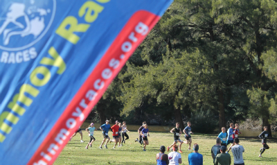
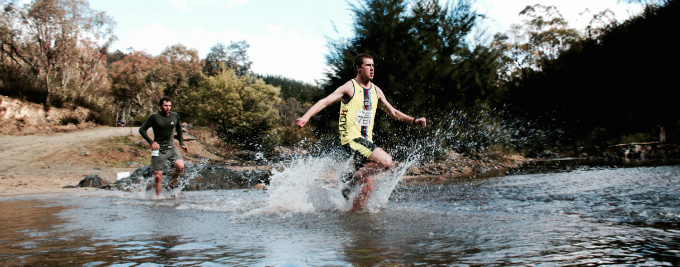
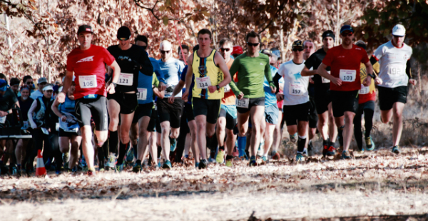
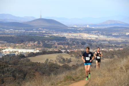
Previous Results
-
2026 Jun 28thSri Chinmoy "Ainslie Amble" 15km, 8.3km & 2km trail races, Sunday 28 June 2026Results (PDF Download)Race Photos
Canberra at dawn. Flocks of birds wheeling and turning high up against the grey sky, exulting in another day of life, an aerial display of avian harmony. Our setup crew are already organising tents, lap counting gear, course volunteers returning from marking the 8km and 15km trails up in the hill, a kitchen team starting on making the 400 plus vegie burgers that are a much anticipated free breakfast for every participant.
Runners are arriving, excited children anxious to start their 2km race run along the flatlands adjoining the bushland; the camaraderie and chatter growing as the race area fills with athletes. What a wonderful sight, these events bringing hundreds of people together to test their fitness, embrace new challenges, mingle with strangers, experience the joy of community and the sense of pleasure at having conquered great distance.Race founder Sri Chinmoy described running as a ‘family picnic’ – our body, mind, heart and soul all get joy, fed by the inspiration and happiness that fitness, striving and personal transcendence always brings. Like the high up birds greeting another day, running is a celebration of life.
Gratitude to all volunteers, helpers, organisers for a very fulfilling trail run.
-
2026 Jun 1stSri Chinmoy Canberra Trail Series 3: "Red Hill Ramble" 12.8km, 8km & 2.4km trail runs, Monday 1 June 2026
Sri Chinmoy Canberra Trail Series 3: "Red Hill Ramble" 12.8km, 8km & 2.4km trail runs, Monday 1 June 2026
1 JuneResults (PDF Download)Race PhotosThe newest addition to the Sri Chinmoy Canberra Trail Series – the “Red Hill Ramble” – proved a popular innovation, attracting the largest field yet assembled for any race in the 10-year history of the Series, with 450 finishers across the 3 distances of 2.4km, 8km and 12.8km.
A cool, clear morning offered optimum opportunity for fast times and full enjoyment of the vistas from Davidson Trig across the Woden Valley, Mt Mugga, South Canberra, Lake Burley Griffin, Black Mountain and beyond. Some steep climbs were more than offset by thrilling views under an all-answering sky, interspersed with a series of flowing single tracks through varied glades of eucalypt, serenaded by cockatoos while immersed in invigorating early Winter air.Congratulations to all participants in this historic event. Because this was the inaugural edition for this course, every age category winner set a new course record which is guaranteed to stand at least until 2027. Our new course record holders are:
12.8km
Female Under 50: Brittany Harriden, 56:01
Male Under 50: Ben Silke, 51:12
Female 50-59: Narelle Smyth, 1:08:53
Male 50-59: David Sitsky, 57:26
Female 60-69: Pam Muston, 1:22:23
Male 60-69: Kerry Baxter, 1:07:02
Male 70 and Over: Peter Fogarty, 1:24:088km
Female Under 50: Louise Sharp, 36:17
Male Under 50: Kodi Clarkson, 29:15
Female 50-59: Ange Hancock, 44:42
Male 50-59: Aston Duncan, 35:49
Female 60-69: Nik Christen, 52:38
Male 60-69: Richard Honey, 45:49
Female over 70: Angelika Mauch, 1:16:56
Male 70 and Over: Eric Wainwright, 1:09:532.4km
Girls Under 13: Chloe Fatherly, 11:36
Boys Under 13: Jarrah Fatherly, 10:49
Girls Under 17: Amelia Powell, 19:14
Boys Under 17: Felix Botticchio, 9:37
Female 17 and Over: Anna Zarifeh, 13:43
Male 17 and Over: David Liu, 12:18 -
2026 May 10thSri Chinmoy Canberra Trail Series 2: "Tidbinbilla Thriller" 11.6km, 6.8km & 3.4km trail runs, Sunday 10 May 2026
Sri Chinmoy Canberra Trail Series 2: "Tidbinbilla Thriller" 11.6km, 6.8km & 3.4km trail runs, Sunday 10 May 2026
10 MayResults (PDF Download)Race PhotosThe harder you have to work for something, the sweeter the rewards.
Every runner who participated in the inaugural Sri Chinmoy “Tidbinbilla Thriller” will attest to this truth.
This newcomer to the Sri Chinmoy Canberra Trail Series made a stunning debut. Entering the stage as the curtain of light mist rose to the sounds of blissful birdsong, attired in the most dazzling Autumn day imaginable, jubilant sunshine bathing the hills in glory, Nature exuberant in every movement and stillness, each sound and hush, cheering each excruciating uphill and exhilarating downhill…
Nestled in the foothills of the Tidbinbilla Range, 3 courses offer 3 banquet options, each with its own enticing menu: the short 3.4km loop of exquisite single track through lush bushland; the middle distance 6.8km extension of the Congwarra Trail venturing to the flank of the hillside with a single robust bent-over climb and stretching of the legs downhill; while the Deluxe Banquet long course 11.8km offers the complete circuit replete with gut-busting zigzagging ascent, breathtaking views across to the Brindabellas you feel you could almost reach out and touch, a series of swooping thrilling descents, alighting to return through the embrace of the bush and the sanctuary of Webbs picnic ground with its proud Finish Arch, smiling watermelon, nourishing lentil burger and the gently soothing sounds of Tidbinbilla River reminding you of your achievement.
Being the premier staging of this event, every winner in every category now holds a course record! Cherish these records while you can because one thing is for sure: crowds will return to feast on the Tidbinbilla Thriller, and challenge themselves to inscribe their own names in the record ledger. See you next year!
New course record holders:
3.4km (short course)
Girls Under 13 – Aya Rattray, 18:53
Girls Under 17 – Jacinta Thomsen, 21:41
Female 17 and Over – Melanie Clarke, 22:08
Boys Under 13 – Alex Botticchio, 16:17
Boys Under 17 – Felix Botticchio, 14:50
Male 17 and Over – Gareth Candy, 16:236.8km (middle distance)
Male Under 50 – Kodi Clarkson, 26:20
Male 50-59 – Aston Duncan, 31:08
Male 60-69 – Richard Honey, 39:39
Male 70 and Over – Trevor Jacobs, 47:00
Female Under 50 – Louise Sharp, 31:58
Female 50-59 – Narelle Smyth, 35:42
Female 60-69 – Patricia Blumstein, 53:17
Female 70 and Over – Deirdre Lemerle, 55:3511.8km (long course)
Female Under 50 – Brittany Harriden, 56:40
Female 50-59 – Shiree Yap, 1:27:23
Female 60-69 – Pam Muston, 1:21:38
Male Under 50 – Jarrod Sopniewski, 51:46
Male 50-59 – David Sitsky, 58:30
Male 60-69 – Ian Prosser, 1:10:28
Male 70 and Over – Peter Fogarty, 1:26:56
About the Organisers
The Sri Chinmoy Marathon Team
Serving the athletic community for over 40 years...

Team Founder Sri Chinmoy
A lifelong advocate of fitness and self-transcendence...
Other Upcoming Events
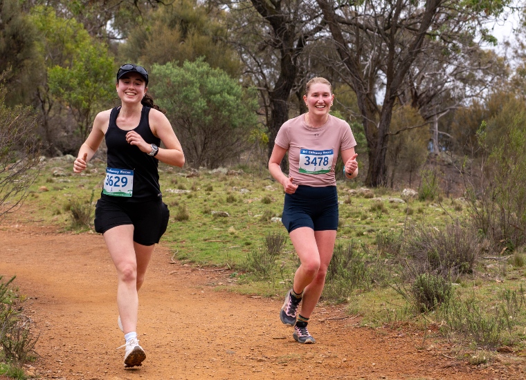
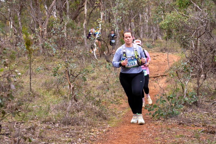
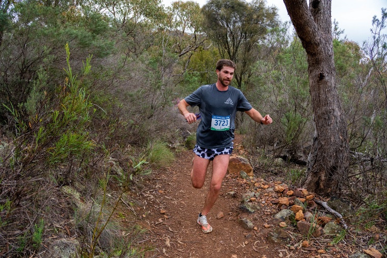
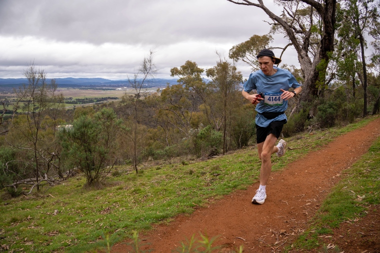
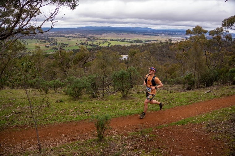
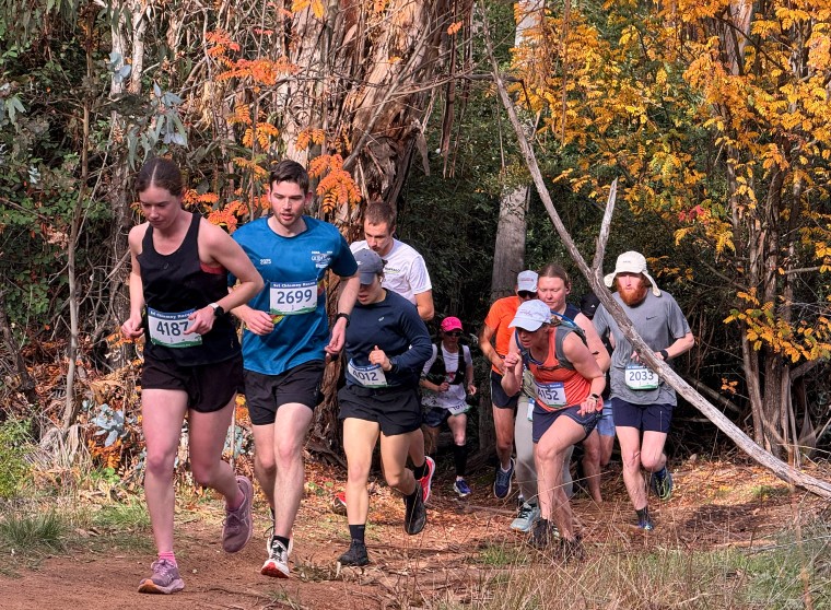
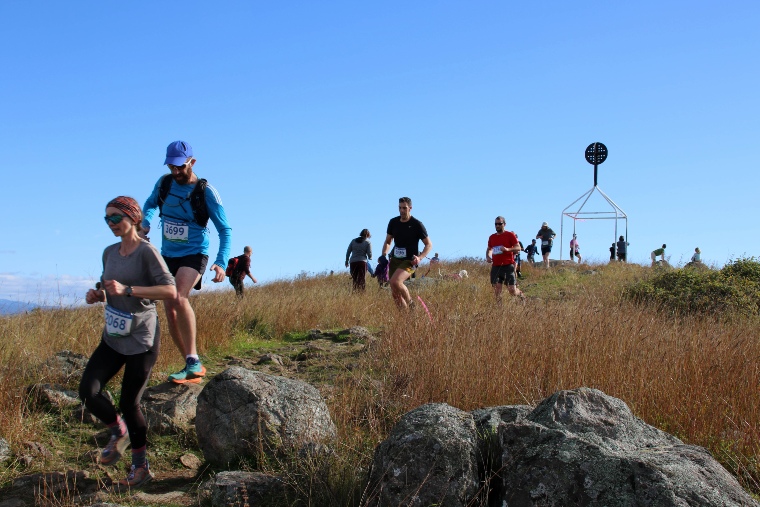
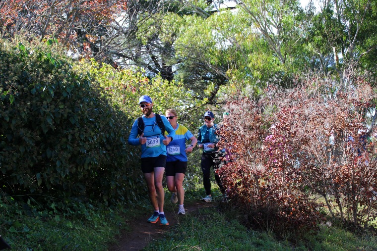
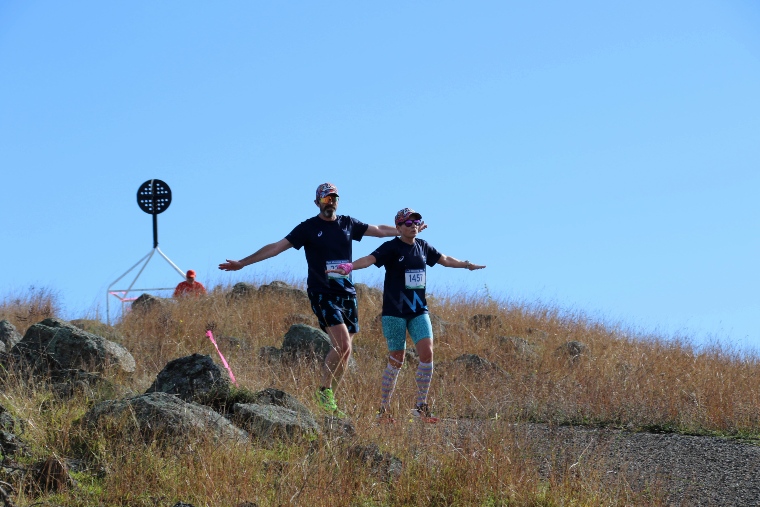
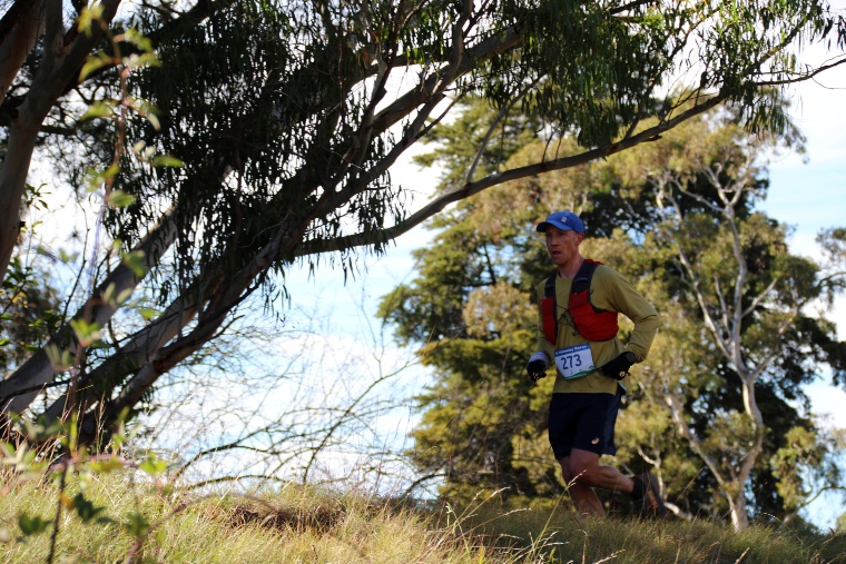
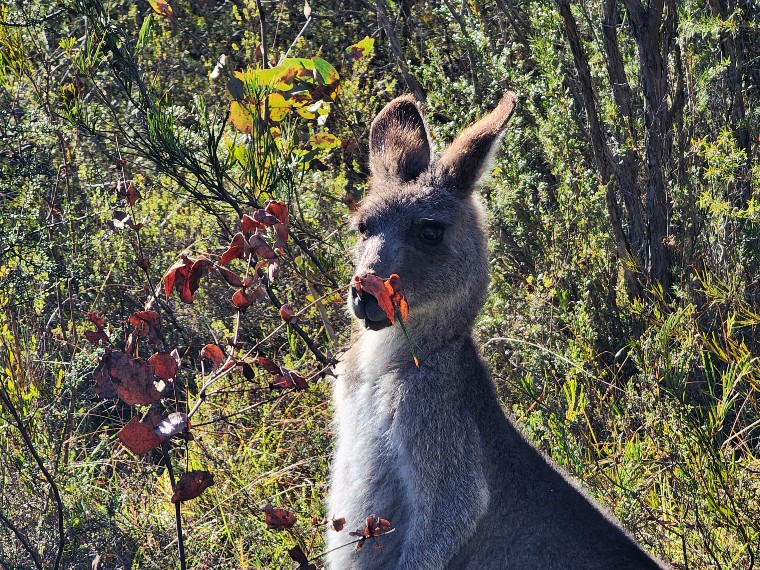
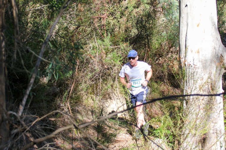
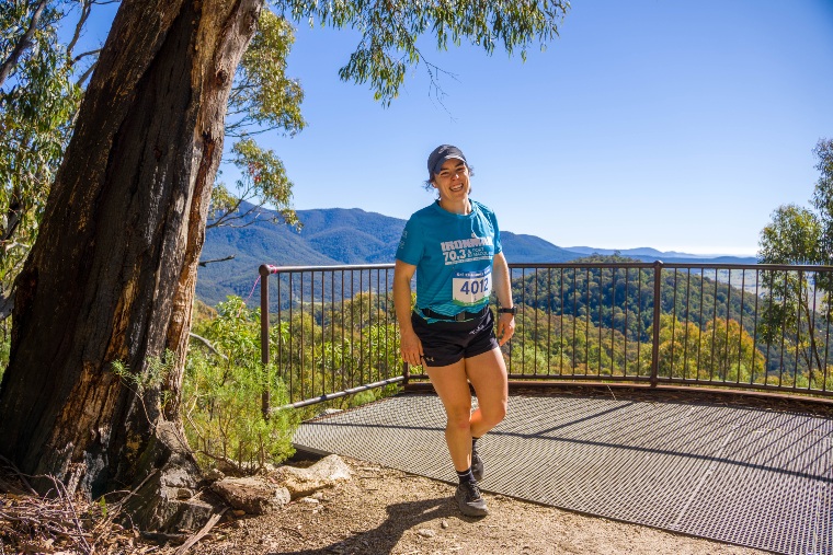
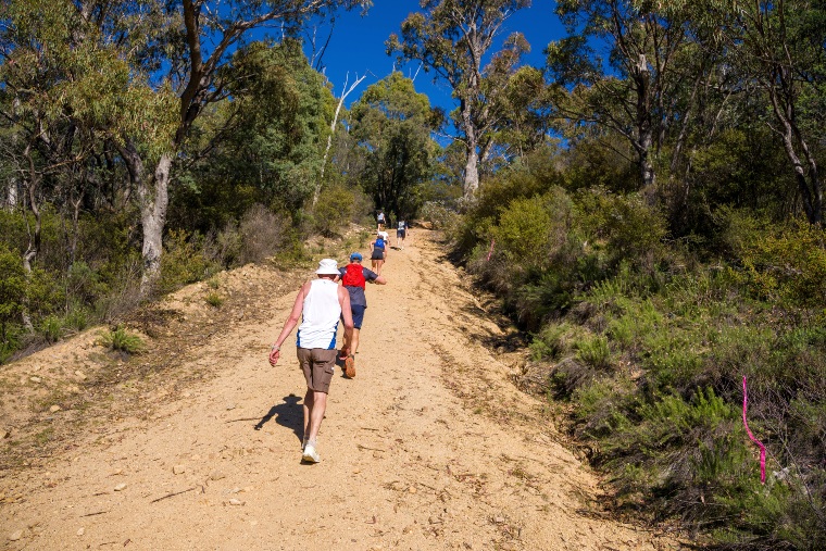
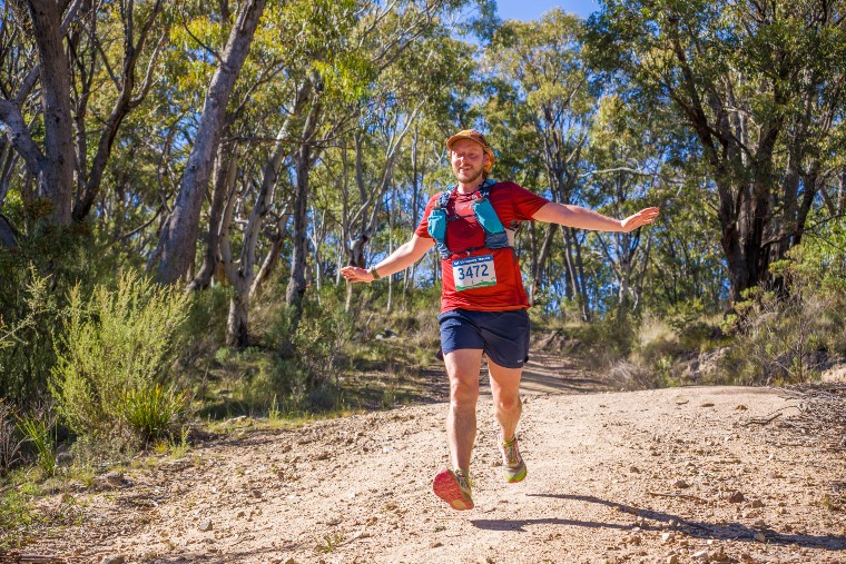
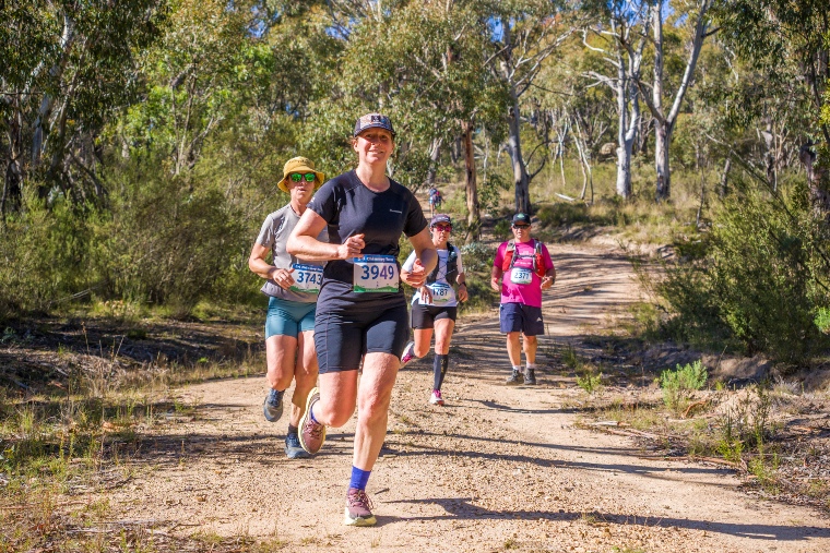
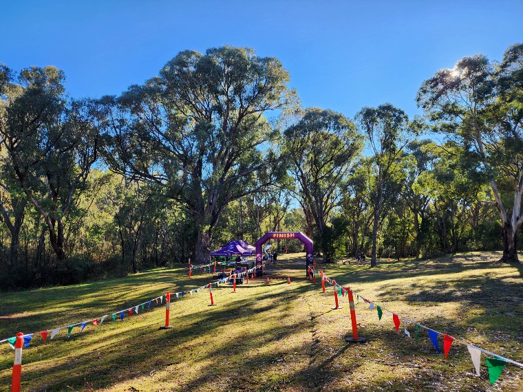
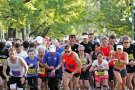
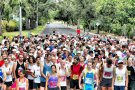
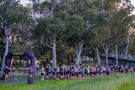
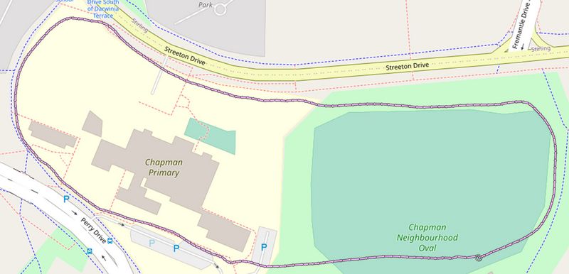
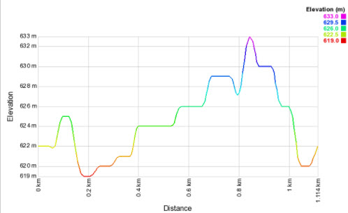
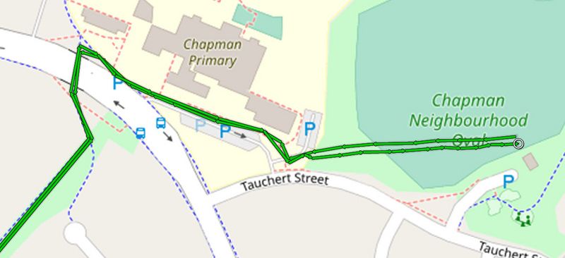
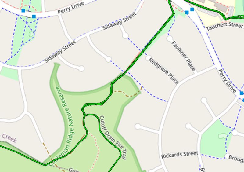
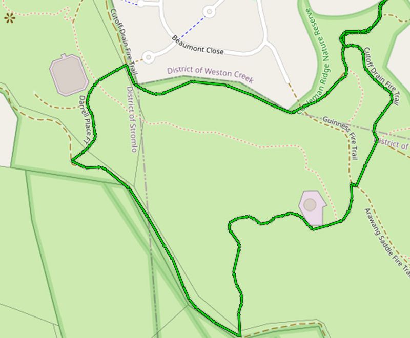
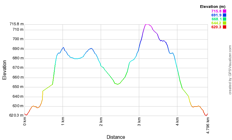
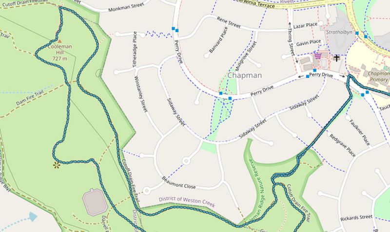
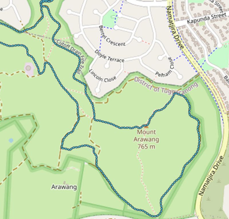
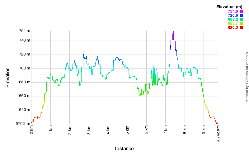
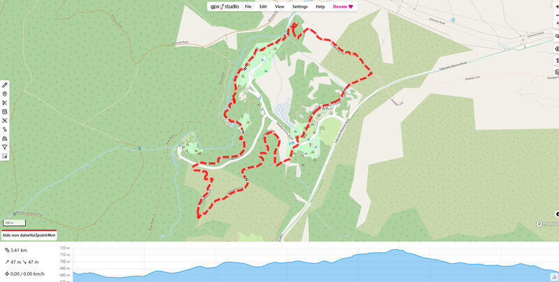
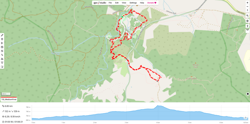
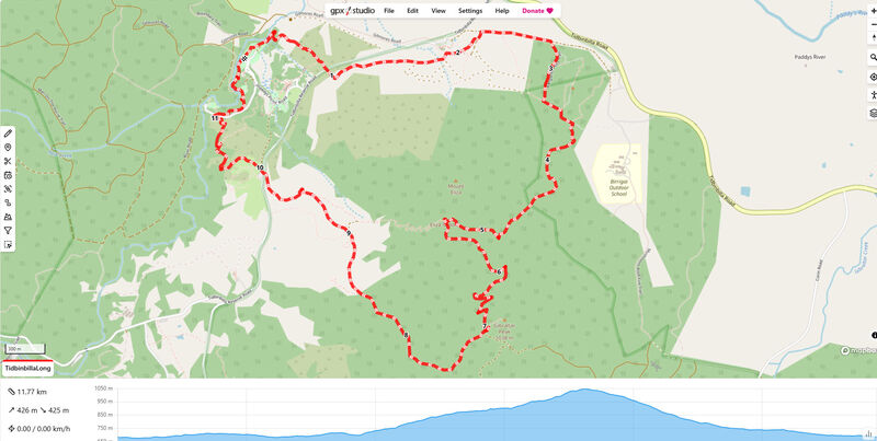
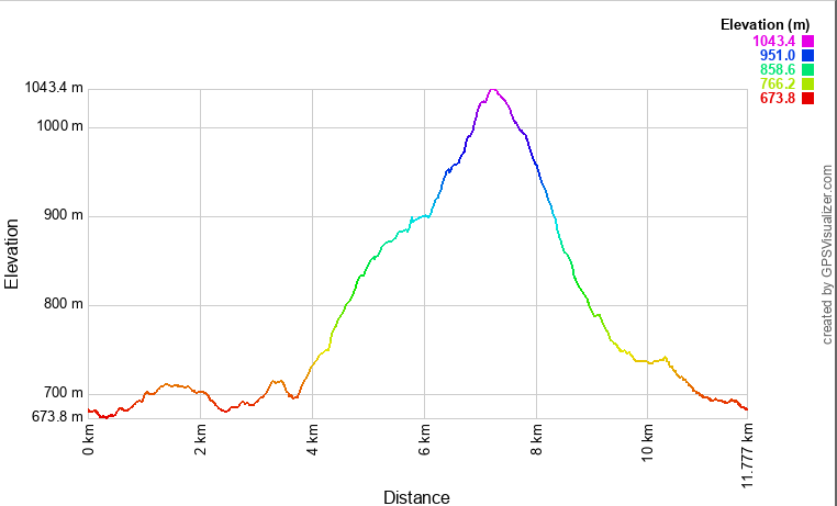
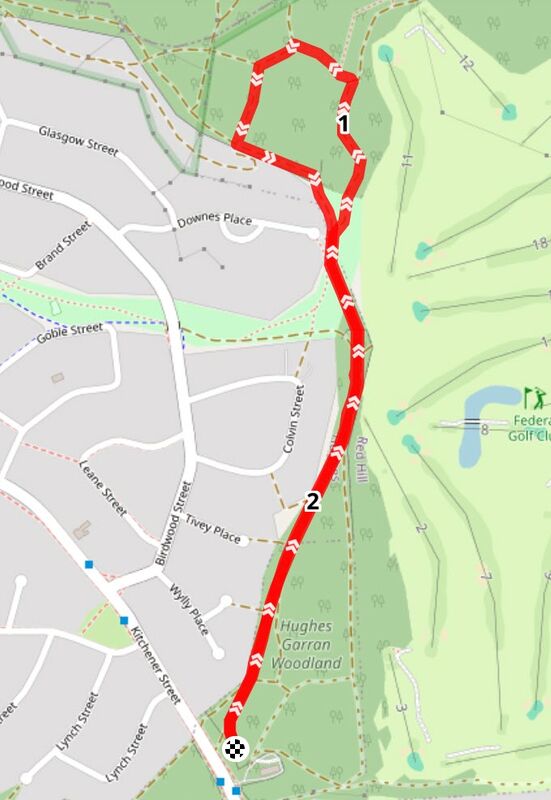
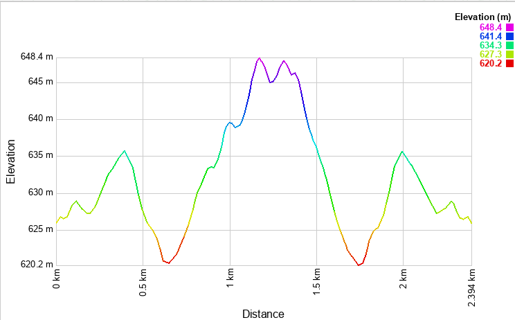
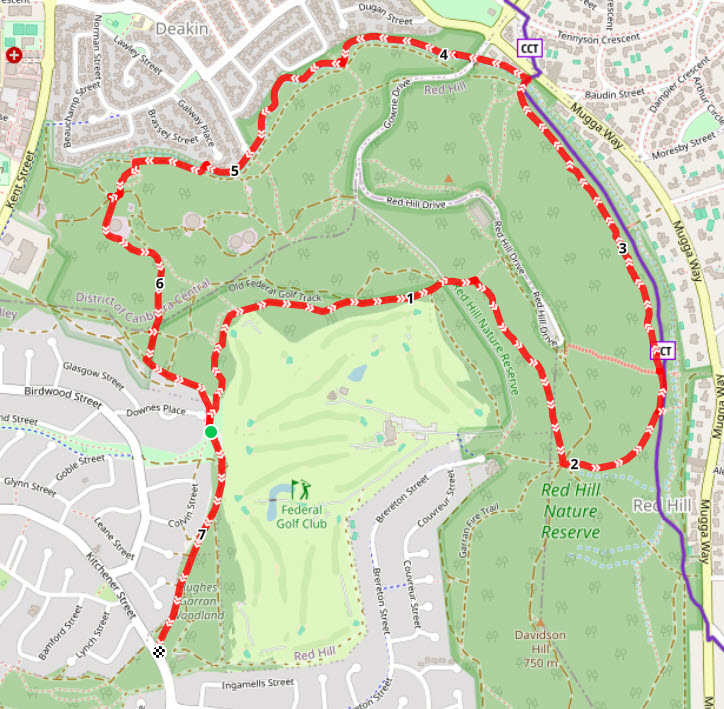
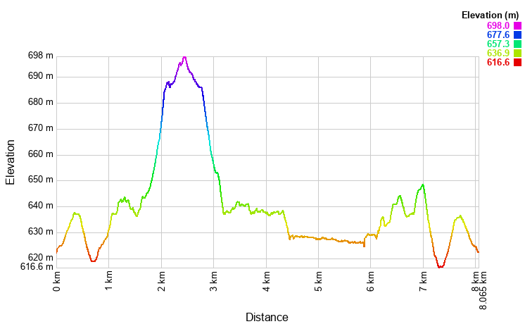
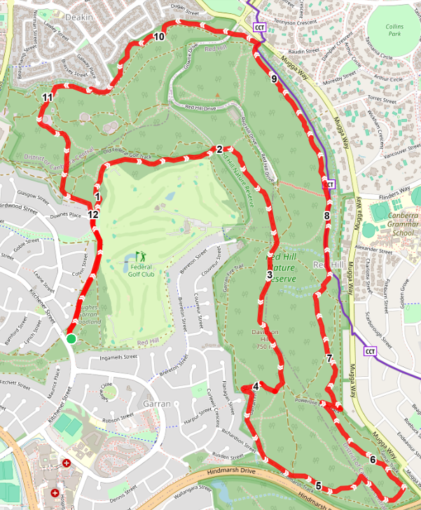
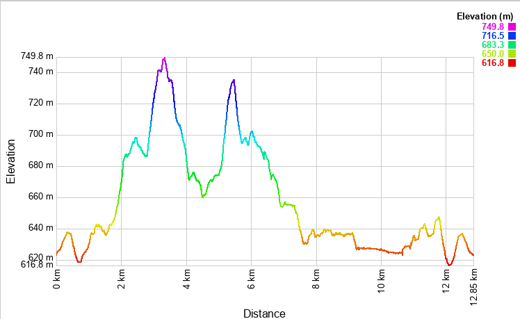
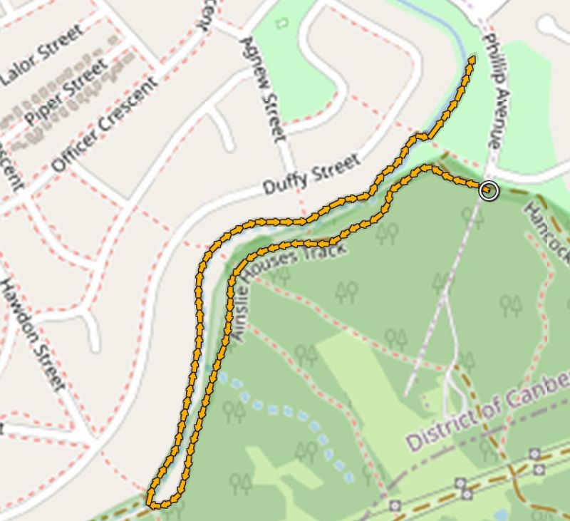
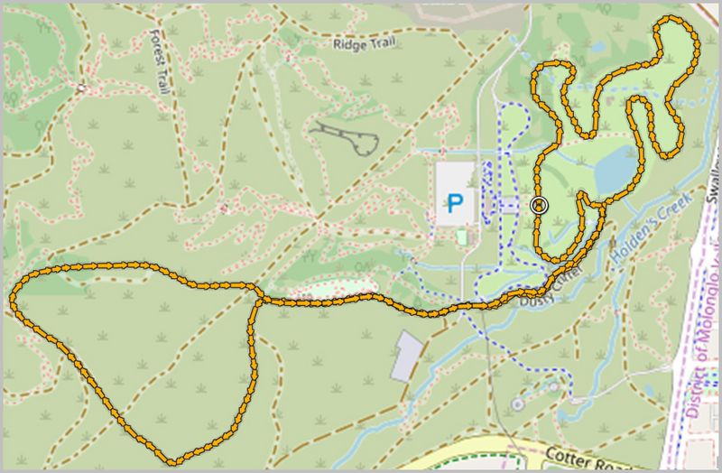
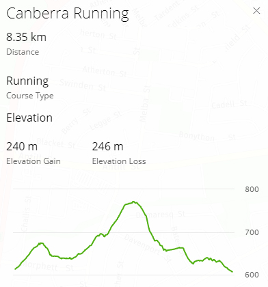
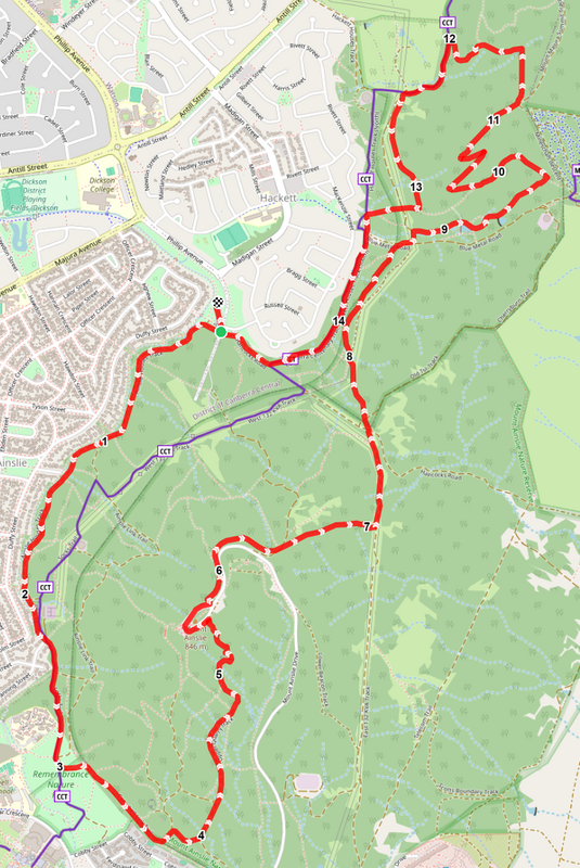
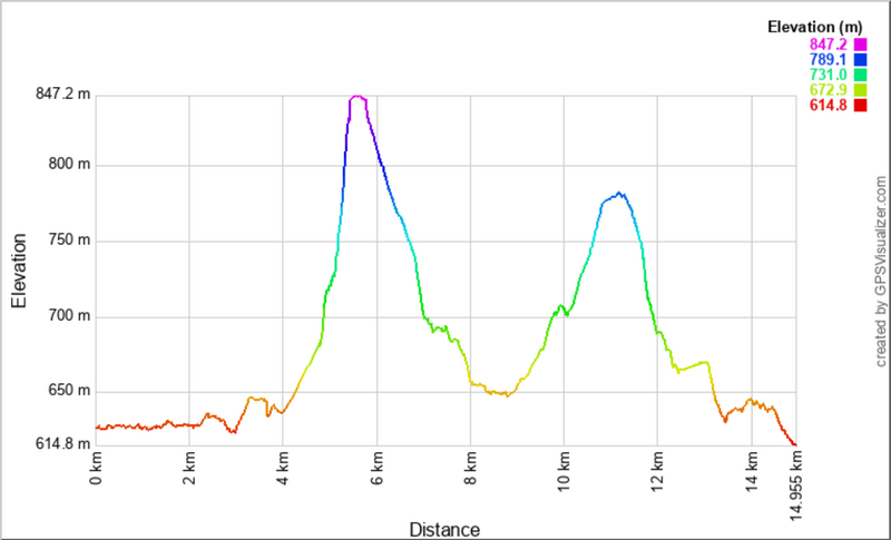
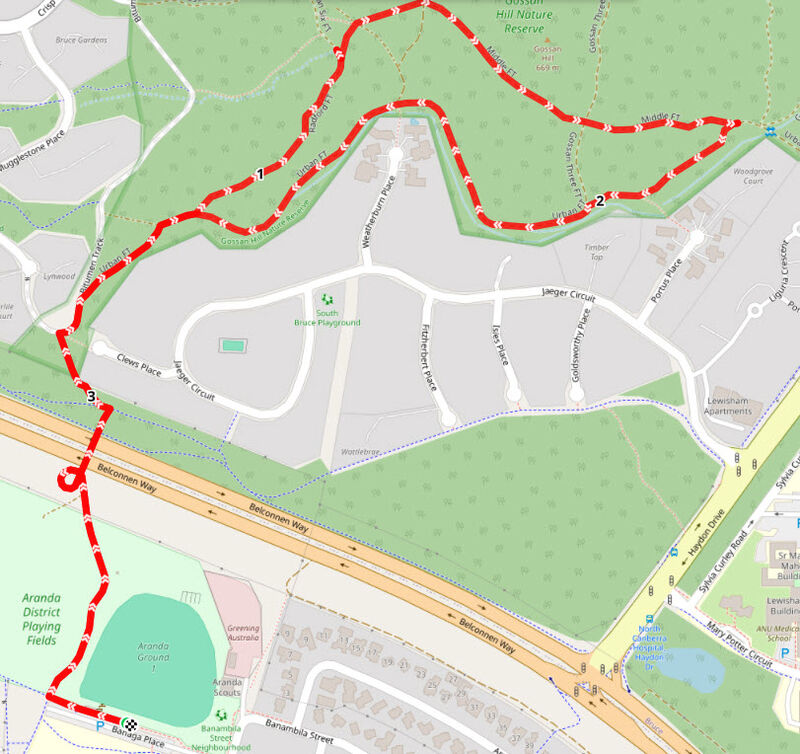
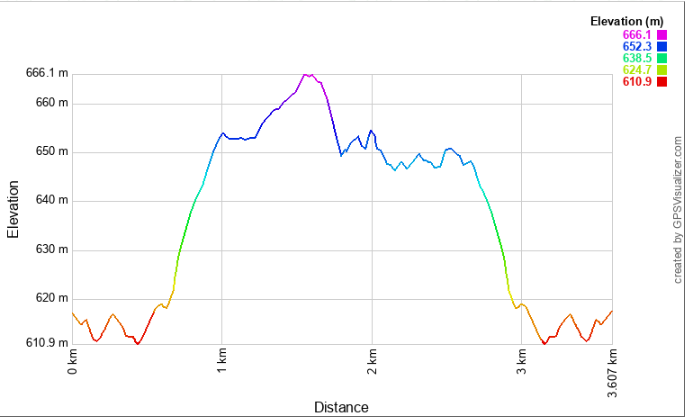
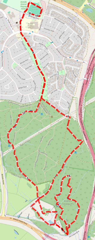
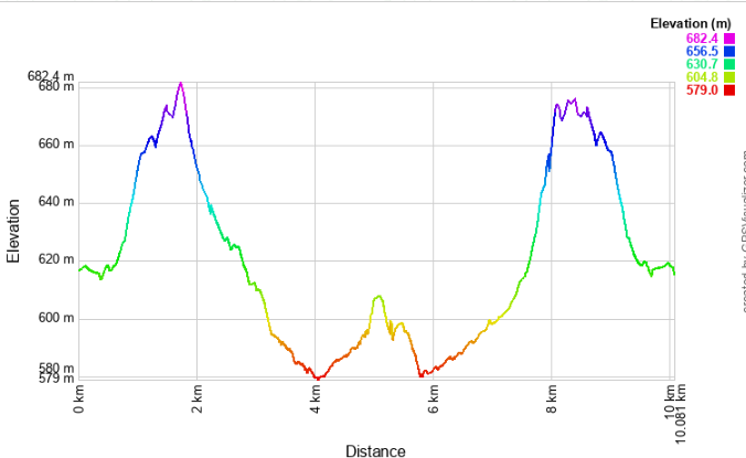
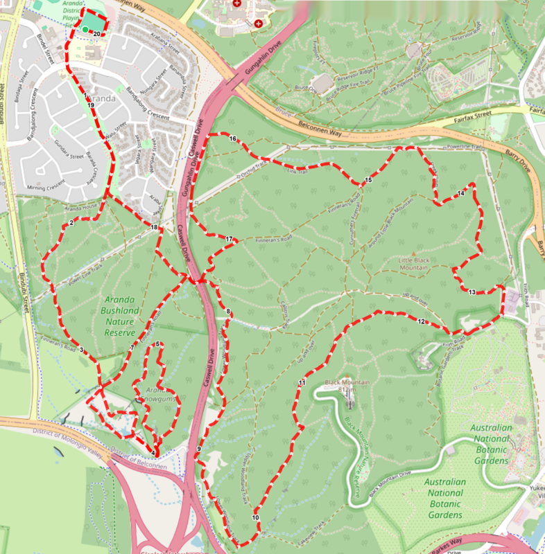
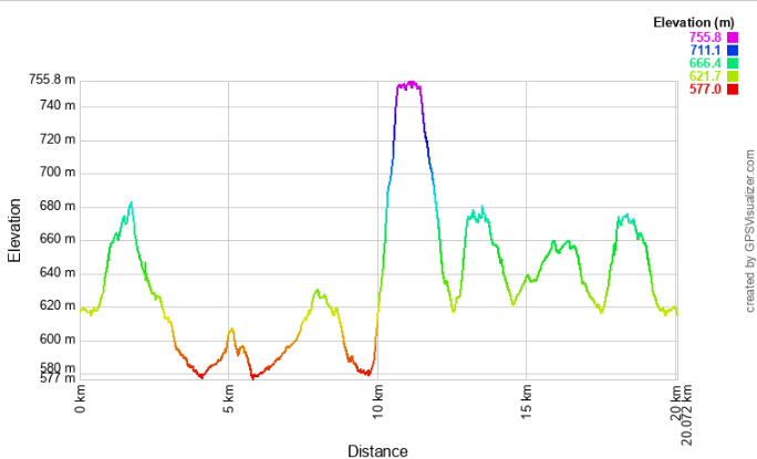
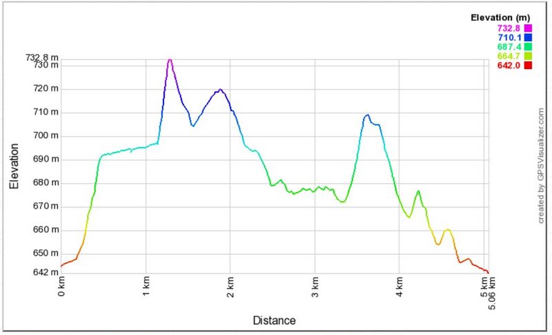
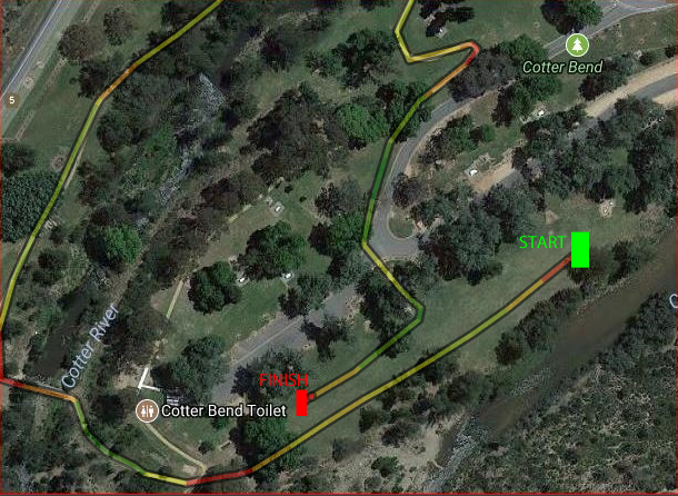
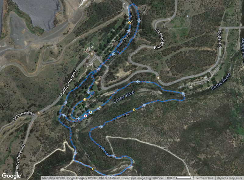
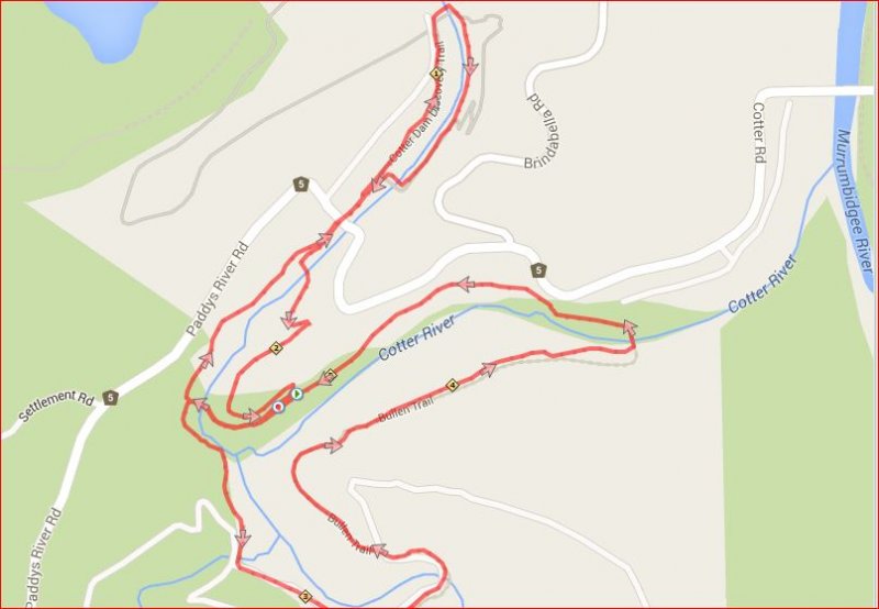
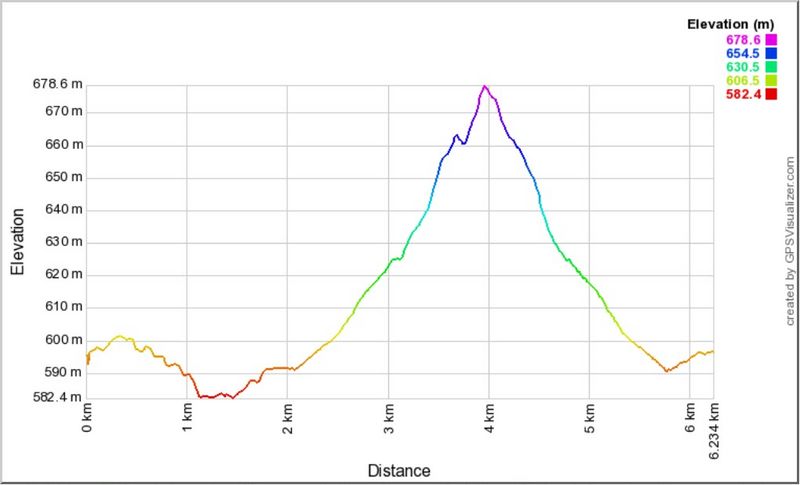
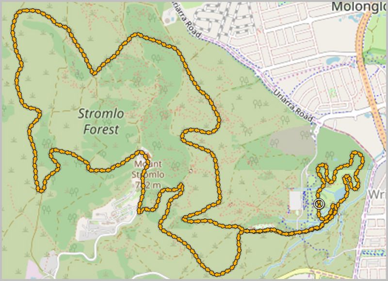
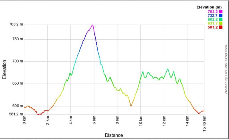
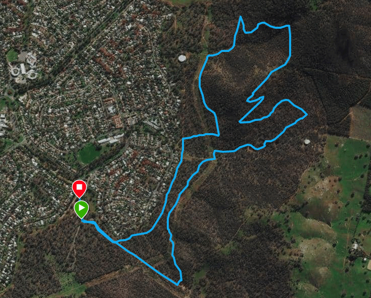
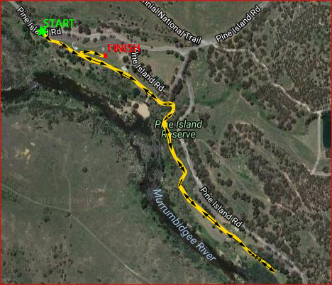
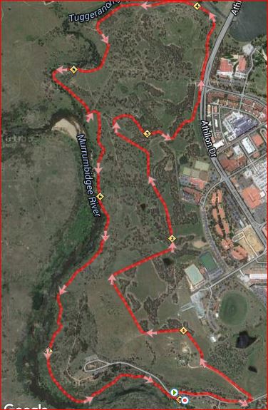
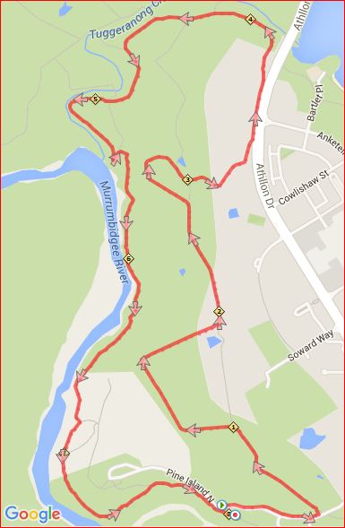
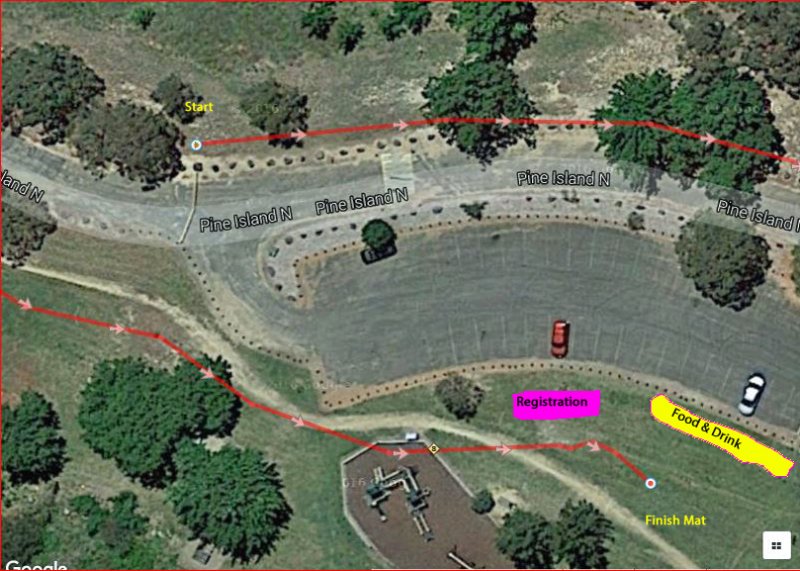
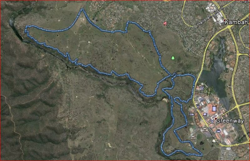
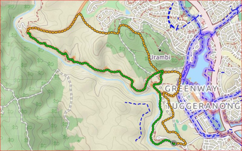
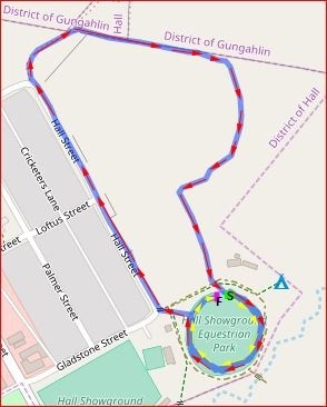
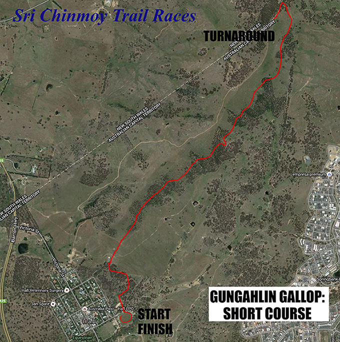
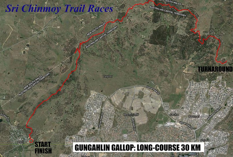