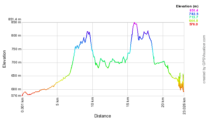
View and download the full course on Garmin Connect. Enjoy a GoPro tour of the entire course for 2023, as ridden by Andrew ÖBerg.
The third and final mountain bike leg starts on the grassed space between KFC and the Tuggeranong Arts Centre on Reed St, Tuggeranong. Stay on the pedestrian path beside the lake and go under Soward Way. Continue following this path keeping the lake on your left and take the first left leading to the bridge crossing the creek. Turn left again at the pedestrian bridge (part of the Canberra Centenary Trail) and cross to the other side. Veer right at the other side, proceeding under Drakeford Dr, at which point the concrete becomes a regular bitumen cycle path heading to the right, then veering to the left past Isabella Pond.
Stay to the left at the next fork - never cross the storm water channel (Tuggeranong Creek), which you keep always to your right. After passing under Isabella Dr, follow the cycle path to the right beside a little dead-end road, continuing alongside the storm water channel. The path leads under Ashley Dr before passing back under Isabella Dr. Ignore the concrete paths heading off in various directions, but stay to the left at the one genuine fork in the cycle path. Continue under Weinholt St, then Kellett St before entering Fadden Pines.
Veer right at the first fork amidst the pines, heading over a small bridge. Follow this path straight past the rain garden feature, near Fadden Pines park (on your left). Soon after, turn left off the cycle path at the next concrete path, which leads past a tennis court complex on your right, then under Coyne St into Macarthur, and straight ahead. Follow this path under the power lines, before turning at the 4th path on your left, coming out at the end of Dennys Pl. At the top of Dennys Pl, cross over Jackie Howe Cres, and continue straight onto the dirt track up the other side, past houses on your right. Go right at the fork in this rough track, past a peculiarly shaped storage tank and yellow day-care centre on your left.
Look for a gate to climb on your right, onto a track heading up the ridge, becoming quite steep and rocky in parts. This ridge ends in a saddle, where you turn left onto a faint track beside a fence heading uphill. Continue along the ridge of Mt Wanniassa to a trig station, offering unparalleled vistas of the whole of Tuggeranong Valley and the Brindabellas.
Take care as the descent becomes very steep to the next saddle, where you turn right onto a walking trail, dipping towards a small dam. Go to the left of this dam, then head for the tunnel underneath Erindale Dr. Cross through the wooden fence opening at the "Equestrian Trail" sign and through the tunnel. After the tunnel, continue straight ahead. Round a small dam on your left, then immediately take a right hand fork to follow the smaller power lines up Farrer Ridge. Follow this track ahead even when the power lines dip to the left. When you reach the next fence, climb over and go immediately left over a mini causeway, then left onto the main track, with the fenceline to your left. Do not take the more obscure track forking to the right, as Mt Taylor appears ahead, and the track dips. Turn to the right at the large reservoir on your left, heading up and back around the rear of Farrer. Go left at the T-junction, following the power lines with the houses of Farrer on your left.
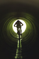 After this track smooths and flattens out, take the first right into the bush up a rocky sidetrack, then right again at a fork. At the fence, go through the wooden opening, then turn immediately right at the main track, through the tunnel to pass back under Erindale / Yamba Dr.
At to bottom of the hill turn left onto the tarmac path, then as the path sweeps right turn harder right against the reserve. In 50m on your right is a concrete / bluestone spill way - on the far side of it, turn right onto singletrack up into the pines - take the right-hand singletrack uphill (The Spine Link - not signed. The left hand trail is DH only.) Once you reach the firetrail, turn left along (rather than crossing) the firetrail for 30m then veer right up onto The Spine trail, marked with an Orange-Red sign. Follow The Spine all the way to the end, turning right / uphill on the tarmac road. The tarmac gives way to dirt, and at the next intersection take the left hand dirt road. At the next intersection turn left onto the next firetrail, up Isaacs Ridge with the Pines on your left.
After climbing a little more, a quarry appears on your right, with panoramic views towards Fyshwick and Queanbeyan beyond. Passing another radio tower, take the right hand fork to pass close to Sheaffe Trig. With the whole of Woden stretched below, the track starts to dip, before switching back to the left and diving into a very steep descent. Go right at the first fork, then right again onto the main walking track.
Enjoy some flat pedalling with the houses of Isaacs and O'Malley to your left. The track begins to dip, with the East O'Malley below you. Before you reach the water reservoir, turn right to follow the Centenary Trail, for about 500m of steady descent though woodland. Follow the Centenary Trail downhill heading NE and through a marshy area, then this trail becomes a lovely single track winding through the forest at the southern end of the O'Malley Bushland, and out again into a more open area. Turn left off the Centenary Trail opposite the next CT marker post, onto a wide 4WD track, heading downhill for about 700m (do not take any side tracks) and bringing you eventually to a metal gate, which you pass through to arrive at a concrete footpath, opposite house number 10 and 12 (with a flag pole). Turn right onto this footpath, which after about 80, turns left, following Keyar St. After another 100m the footpath turns right. Follow this path around the left hand side of the playground, staying always off the road, and look for a turn to your right, through another gate, then up and over a steep dirt embankment, and down into the long pipe under this Hindmarsh Drive, turning to the right as you emerge at the next transition compound.
<Previous | Next> Back to Contents