
AustraliaSri Chinmoy Marathon Team

  • About us
  • Our races
  • Results

Search form

Founded by Sri Chinmoy in 1977, the Marathon Team is one of the world's largest organisers of endurance events.
read more »

Gallery

Thousands of event images

History

From 2 to 3100 miles

Sri Chinmoy

Marathon Team Founder

Next Event:

2 June - Canberra
Sri Chinmoy Canberra Trail Series
Details »

More events:

Brisbane
Canberra
Jindabyne
Melbourne
Sydney
View all events »

Worldwide:

View full list »

Latest results:

11 May - Canberra
Sri Chinmoy "Stromlo Strides" 15.4km, 6.3km & 2km trail runs, Sunday 11 May 2025
Details »

Previous races

View all results »

Worldwide results

Full list »

Sri Chinmoy Williamstown Foreshore Run 2007

By Rathin Boulton
17 June

5 km Run>>

5 km Walk>>

10 km Run>>

Sri Chinmoy Marathon Team articles - more articles

Sri Chinmoy Canberra Trail 100, leg 2

By Prachar Stegemann
22 September

Leg 2: end of Waldock St, Mount Taylor to Kirkpatrick St, Weston (next to RSPCA), 27 km

Download the complete navigable leg 2 route map (coming soon), and leg 2 gpx file.

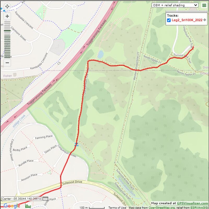
From the transition at the picnic table above the end of the car park at the end of Waldock St, following the small track along the fenceline parallel with the road, then veer left 45 degrees to a dirt path about 50m short of the gate. Continue straight ahead 80m later to cross Nth Taylor Fire Trail (FT) and head down into the gully on the narrow single track (ST). Cross the West Powerline FT and continue straight ahead (W) down onto the Old Kambah FT. After passing a dam on your right the trail swings left (S) and heads down to a climb-through gate. Continue straight to cross Colquhoun St and follow the dirt track on the LHS of the houses for about 150m before turning left onto a bitumen path which heads under Sulwood Dr.
 

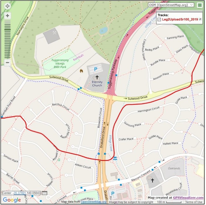
Immediately after exiting the underpass turn right to follow a dirt track between the houses and the road. At the end of the house fences do not follow the fence line to the left but instead continue another 30m straight into a watercourse (Village Creek) and then turn left to follow the grassy ST between the trees that runs parallel to Drakeford Dr. Turn right at the first footpath you come to head under Drakeford Dr. and upon exiting the tunnel continue straight ahead on the path that heads between the houses, taking care to cross Bacchus Cct and continuing straight until the path ends at Attiwell Cct.

Continue straight to follow the RHS verge of Attiwell Cct for approx. 250m before turning right at the T-jn onto Bacchus Cct and then immediately left into Lunn Pl. At the footpath 20m past the end of Lunn Pl take the faint ST at 10’o clock heading which merges with a footpath which leads up to a bus stop at Kambah Pool Rd.

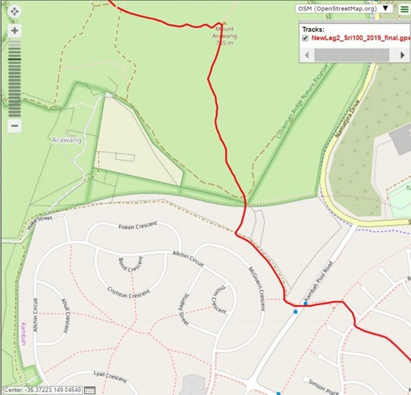
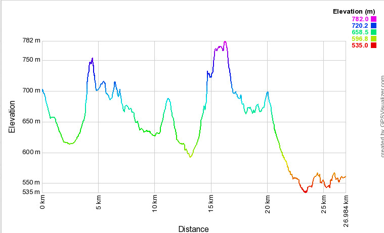
Cross the road according to the marshal’s instructions and head straight up onto the footpath heading up the hill. After 80m turn right at the fence line to leave the path and head around a gate uphill (N) onto a dirt track. Turn right after approx. 300m (where the track flattens out near the houses) to climb through a wooden gate towards Mt Arawang. Follow the ST for 110m to climb through another wooden gate. Cross over the gravel road here and continue straight ahead on the Centenary Trail (CT) over a footbridge onto the Mt Arawang Summit Trail – the steepest section of this leg. Climb for 670m to the Mt Arawang summit trig. Turn back the way you came, and immediately take the small track that heads steeply downhill to your right, heading towards Cooleman Ridge and Mt Stromlo.

After descending through trees for 380m, continue straight ahead at the 4-way intersection, rejoining the CT along Cooleman Ridge.

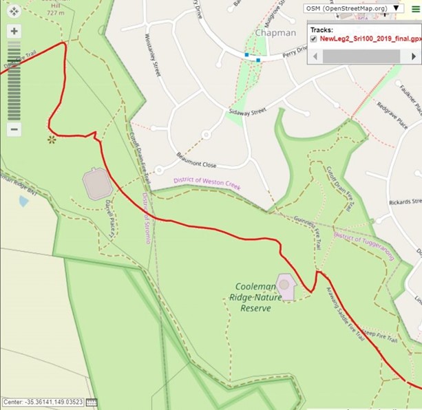
Veer right (R) at the fork after 50m, continuing on the CT for another 450m, then turn L at the T-junction with the Guinness Fire Trail (FT), then R again after 90m at the CT sign onto a foot track in front of a water storage tank. You are now heading NW along the ridgeline of Cooleman Ridge. The track dips and after 600mcontinues straight at a 4-way intersection and through an open gate. 170m further on, cross straight over the Darrell Place FT, alongside another larger water storage tank. The CT track rises and veers left at the fork after 170m, through a stand of trees and beyond, with sweeping vistas to the E across the Bullen Range to the Brindabellas, then following a lovely fast trail along the W of the ridgeline through woodland.

The course now departs the CT, turning L (heading downhill) at the 4-way intersection onto the Dam FT (at about 7km elapsed of this leg).

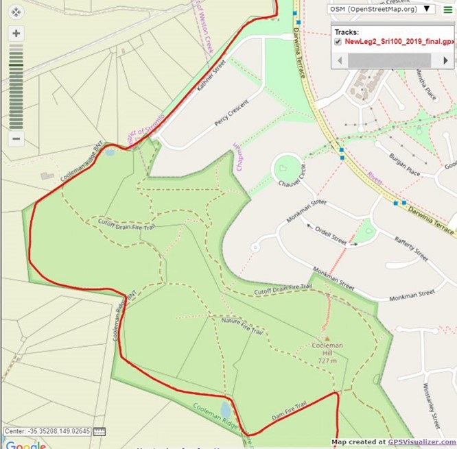
After descending for 300m, climb through the gate and turn R at the Cooleman Ridge Bicentennial National Trail (BNT), heading N. Climb through another gate after 620m, and immediately turn L onto a foot track heading W, keeping the fenceline to your left for a further 640m. Alongside a house on your left (the best situated house in Canberra?), rejoin the Cooleman Ridge BNT, heading L and continuing NE. The CT rejoins your route as you continue to the W of a small (sometimes dry) dam, continuing for another 340 as you swing around the N end of Cooleman Ridge, crossing a cavaletti (horse logs) to reach the intersection of Kathner St with Percy Crescent, Chapman.

Follow the track along the W side of Kathner St, which turns to the L, parallel with Darwinia Terrace. Keep the fence line on your left and after 130m turn left once again, staying next to the fence, to head W towards the Mountains.

Stay L at the fork at the track, where the CT continues to the R. You will come to the 1st drink/aid station (approx. 9.7K elapsed) just before crossing the equestrian centre access road. Climb across the stile over the fence and follow the track W along the fenceline, which passes a dam after about 400m and then curves to the right to bring you to a gate (may be open or closed) and a T-junction, at which you turn left.

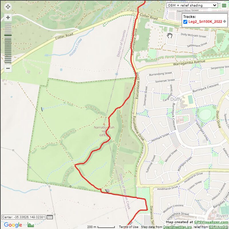
Follow the main wide FT which heads N and then NW heading gently uphill. Follow this for 440m until the first 4-way track junction, at which you will turn right uphill, into the pines. After a steady climb the track temporarily flattens out (after 560m) at a T-junction, where you will turn left to head uphill towards the Narrabundah Hill Trig. About 250m later you will see the faint track to the Trig on your left (you do not need to go to the Trig)  – continue straight ahead and 70m later turn right to take the track heading downhill (with Telstra Tower and Black Mountain straight ahead of you in the distance).

This track continues down towards the road,passing two metal climb-through gates that may or may not be open on the day. As the trail approaches Eucumbene Drive keep right along the fence line to reach a pedestrian stile that you will climb over (approx. 12K elapsed). From here turn left (N) to follow the dirt path which becomes a small dirt ST that runs downhill alongside Eucumbene Dr to Cotter Rd.

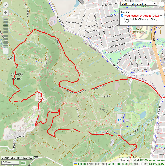
Cross Cotter Rd according to the marshal’s instructions and enter a ST that soon merges with a larger track and 100m later passes the Canberra Bushfire Memorial where you take the bike path to your left (about 13K elapsed), heading towards Mt Stromlo. After 350m or so the path climbs to a paved road at which you will briefly turn right and then immediately left onto a major dirt road heading uphill. After approx 500m continue straight at the road junction to continue climbing uphill towards Mt Stromlo. After another 400m or so the road enters the blue gums and then swings left to climb up to a track intersection. Turn right at this intersection onto the Ridge Trail to head another 500m as the road swings right to the N, climbing steadily to a T-junction with a view of the Stromlo MTB course tunnel where you will turn left (uphill, heading SE, away from tunnel). This dirt road heads for approx 500m W and then SW to join Mt Stromlo Rd, where you turn right to follow the road all the way straight up to the top of the hill (no turns) and run a semi-circle around Mt Stromlo Trig (about 16.4K) before taking the white concrete footpath down heading W.

Continue down the path to the first metal gate and then bear left (S) to pass a 2nd metal gate and follow a steep descent down a dirt road that heads SW/W for a little over 400m before it reaches a T-junction where you will turn right onto a dirt road that soon swings further right to the North to run parallel with the ridgeline above. After 400m this road has a short climb and then descends (NNW) for approximately 300m to bring you to a major track intersection, where you will turn right (NE) onto the Forest Trail (approx. 18K).

Follow the Forrest Trail winding around the base of Mt Stromlo for about 2.3km, avoiding all potential turn-offs, until you turn L onto the Carpark Trail (about 20.7K).

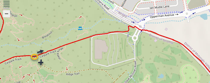
After 270m on the Car Park trail take the left track (“Pool Link” black sign). After 290m continue straight ahead (don’t take MTB single track to left) for 70m to go through a gate located at the NW corner of the Stromlo Leisure Centre building.  Head down the grass verge beside the road for 120m before it becomes a bike path, and then 80m later take the bike path to the left towards Uriarra Rd, and then 20m later turn right on the bike path down to the SW corner of the roundabout, near the road entrance to SFP. Do not cross the road in front of you, but instead turn right (to the SE) to carefully (watch for traffic!) cross the exit and then the entrance roads to SFP to join the abandoned section of Uriarra road (currently temporary parking for SFP) heading down the hill towards the apartment complexes.

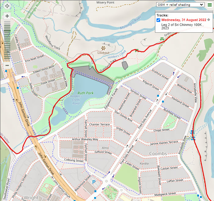
Near the bottom of the hill, you pass a swing gate and 70m later turn left onto Swallowtail road and follow for only 30m before taking the small dirt track to your left which then leads to a bike path which loops under John Gorton Drive and continues around the LHS of Holden's Creek Pond. Turn L at the T-junction at the end of the pond (about 22.8K) and soon after (about 50m) turn R onto the Grasslands Track, which you follow as a single track past two Picnic Shelters before it merges with the main dirt fire trail (about 23.6K). This fire trail follows a big bend in the river before swinging south back towards the Coombs houses, where it eventually becomes the bike path (approx. 24.3K).

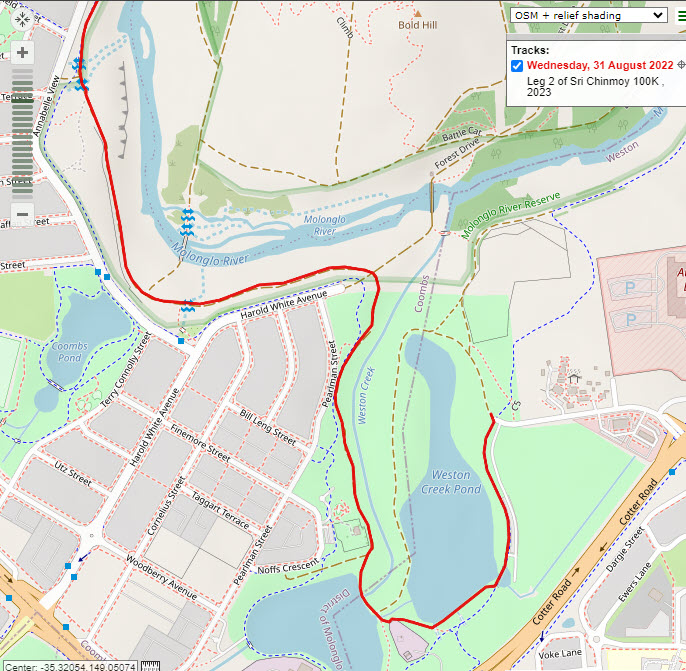
After 400m on the bike path you will leave it, veering left (approx. 24.7K; basketball net on your right) to take the grey gravel path through the brown entrance poles. After another 500m or so the track swings left and heads up a gentle hill. 40m after passing through the walking track gate you will reach a 4 way junction (approx. 25.6K) at which you will continue straight ahead to a brown dirt track that soon swings right to head south alongside the Weston Creek watercourse pipe. Follow this gravel track uphill past the flagged off erosion hazard until it joins a bike path (approx. 25.8K) for about 100m before veering left and down towards the Stromlo Cottage (about 26.2K).

Soon after passing the cottage veer 45 degrees left to take the dirt track between the ponds, which soon brings you to a 3 way track intersection (approx. 26.3K) where you will turn briefly right and then only 20m later, left onto a small single track that follows the southern end of the pond. Follow this along the pond edge for about 300m until it joins the bike path (approx. 26.6K), at which you will turn left and head up the hill to turn left onto the wide dirt track opposite the end of Kirkpatrick St. The Transition point is approx. 20m along this road (in line with a gate on the RSPCA HQ up on the hill on your right).

View full article »

Sri Chinmoy Canberra Trail 100, leg 1

By Prachar Stegemann
22 September

Leg 1: Rond Terrace to Waldock St, Mount Taylor north side, 25 km

2021_Leg1ElevationProfile.jpg

Download the complete navigable leg 1 route map, and leg 1 gpx file.

newMap1a_2020.jpg

The start line is lakeside, in front of Rond Terrace on the North side of Lake Burley Griffin.

Follow the lakeside path (RG Menzies Walk) heading NW and then W towards, and then under Commonwealth Avenue Bridge (see detailed map, below).

Leg1detail_underCommBridge.jpg

Before Henry Rolland Park, cross Barrine Drive, and follow the cycle path up the ramp onto the pedestrian pathway heading south across Commonwealth Avenue Bridge. Take the first R after the bridge onto the cycle path heading W alongside Flynn Dr.

newMap1b_2020.jpg

This path passes Nara Peace Park (toilets) then swings to the right near the roundabout (RDBT) after which you immediately turn left to cross Alexandrina Dr to follow the bike path up towards Parliament House. This path crosses Forster Cres, passes under 2 roads and then becomes narrow and climbs more steeply.

On the way up the hill turn right at the first path junction and then right again when you reach Parliament House to follow the grassy path on the right-hand side (RHS) of the road. After approximately 200m turn right at the first road (Melbourne Ave) to stay on the RHS footpath, which crosses a bridge over the road and leads down to a pedestrian crossing/lights at State Circle. 

map2.jpg

After crossing State Circle follow the footpath uphill on the RHS of Melbourne Ave, taking care crossing Somers Cres, National Cct, Dominion Cct, Empire Cct, and then Gawler Cres at the traffic island (at the end of Canberra Girls Grammar School), and head across to the RHS footpath towards Red Hill. After approx. 150m cross Stonehaven Cres at the RDBT to join the grassy verge on the RHS of Red Hill Dr. and then 130m later turn right immediately after crossing the bridge to join a dirt single track (ST) which then merges with the wider Deakin Reserve Fire Trail. After approx. 1K turn left at the Rutidosis Track sign to climb through a metal fence and then 20m later turn right to head steeply up the C. Russell Track.

Turn left at the next T-jn to continue uphill on a gravel road and then 100m later turn left again at the saddle track intersection to head steeply uphill once again.  After passing through a metal stile take care crossing Gowrie Dr, head up the stairs and again take care crossing Red Hill Dr, entering the steps and dirt ST heading steeply uphill, which soon opens up to a right hand turn at a T-jn heading towards a radio tower. At the Red Hill Lookout Bay turn right towards the power pole to once again cross Red Hill Dr and then turn immediately left to join the dirt ST, which heads past the water tank reservoir and soon turns right and briefly down before climbing again along the fence line towards Red Hill restaurant, with expansive views of the Woden Valley opening up to your right. This track levels out near the public toilet next to Red Hill restaurant (toilet & water available), descends to a 6-way track at a saddle and continues straight ahead, up a steep climb, becomes sealed and then flattens out.

2021_NewMap3_0.jpg

Near the top of the final climb detour left onto 30m of dirt ST to touch Davidson trig and then re-join the main trail again 50m later. Continue straight at the bottom of a short, steep descent as the track flattens and widens and becomes dirt again and after 200m or so take care to continue straight ahead to re-join the flat bitumen path.

The path then drops steeply down to a climb-through metal fence.  Turn right onto the main Hindmarsh Track, staying near the fenceline for only 200m before turning 10 o’clock downhill onto a wide track that veers left after 200m (pedestrian detour) and narrows to single track running just beneath Hindmarsh Drive. After another 150m take care to veer right off this ST following the ribbon to your right, keeping the retaining wall behind the houses to your right. This will lead you down to the First Drink Station and a pair of large drainpipes on your left. Crouch down to go through the RHS drainpipe tunnel that takes you under Hindmarsh Dr. for approx. 60m.

Immediately after exiting the tunnel, turn *RIGHT* to climb up the earth bank and then drop down to join the footpath on the East side of the O’Malley houses. Stay on this path, taking the path that stays to the left of the playground, climb the stairs and head approx. 100m until the first street (Keyar St), where you turn left – staying on the footpath – to head down back towards the bush. After about 100m this path turns right and approx. 80m later look out for a metal gate on your left opposite house numbers 10 and 12 (flag pole). Turn left through this gate to follow a wide track that takes you uphill for about 700m (do not take any side tracks) where you come out into a second open area and turn hard right (change from heading East to SW) at the junction with another main trail (Centenary Trail). Follow this downhill onto a lovely single track cruising back into the forest towards the southern end of the O’Malley bushland, crossing a marshy area at the bottom and then starting a another climb heading SW.

After approx. 500m of steady gentle climb this track merges with a wider track from the left and 60m later you veer left (11 o’clock) onto a small access ST for 30m and turn left again at the T-jn (Equestrian sign) to head uphill. Follow this main track up the hill and then along the flat section above the houses in Isaacs for about 1.2K before entering the pines, taking care to stay on the left (higher) trail before turning hard left at the first equestrian sign then 40m later staying left at the fork to head very steeply uphill.

map4_2016.jpg

At the top of this steep pitch the track swings East while offering expansive views of the Woden Valley and beyond to the North, climbs gently to Sheaffe Trig and then follows the fence line along the ridge for approx. 1.2K.

Along the way you head down to a minor saddle, a small climb, and then descend to a major saddle where you merge with a wider road to continue heading uphill to your right. Just before the top of the climb take the right fork in the track to soon merge with the ridgeline track near the orange/white radio tower and then only 30m later turn right (downhill) onto a fire trail which heads down into the pines. After 400m or so this trail turns right and drops very steeply for about 300m before swinging hard right again along a gentle descent between the pines.  Turn left (downhill) 300m later at the next intersection and follow this for only 100m before veering right to join 40m of dirt ST that cuts the corner to join another equestrian track heading right towards Shepherdson Pl.

map5_2016.jpg

After 200m turn left to take the sealed path uphill to pass under Yamba Dr. – approx. 50m later veer left uphill off this track at approx. 10’o clock heading to pass a wooden fence and continue straight through to a very rocky 200m stretch of track which swings left and downhill towards the houses at Farrer. Turn left onto the track behind the houses and after 500m or so take care to stay on the right, lowest, flat track (2 o’ clock heading) that stays closest to the houses. A bit over 500m later when the main track turns left you can cut the corner to the right following 80m of ST which then merges with another main track that heads roughly parallel to the Farrer houses. About 600m further on you should bear left at the fork in the track (equestrian sign) to head away from the houses. This track starts to descend past the RHS of the water reservoir and soon after turns left, heading straight towards Mt Taylor and downhill to cross some wooden equestrian stiles to arrive at the 2nd drink station on the eastern side of Athlon Dr.  This is the largest and most dangerous road crossing of the race and you MUST obey the road marshals’ instructions as to when you can cross both double lane sections.

map6.jpg

After crossing Athlon Dr you cross a bike path, go through a gate near a stile and continue directly uphill on the Torrens Houses fire trail (FT). A bit over 1K later (near the corner of the housing line on your right) turn left, uphill, at the Mrs Low’s FT sign to pass through a gate, and 70m later turn right before the tourist information board to head steeply uphill on the track that leads up Mt Taylor. This narrow track passes several lookout chairs that offer great views of the Tuggeranong Valley and the Brindabella Mountains before becoming stepped and steeper and then opens out to a wider road that soon turns right and climbs very steeply towards the radio tower. At the top of this steep climb veer right onto 60m of rocky ST that takes you to the Mt Taylor trig and then 60m back left to re-join the main FT heading North, which drops gently, turns to bitumen, and then drops very steeply, offering a dramatic view to the North.  The road briefly turns back to dirt and temporarily flattens out before swinging left (West) and dropping steeply once again on a 100m bitumen section. Turn right (2’o clock) immediately at the end of this bitumen section onto a dirt track and 100m later bear right at the fork, continuing 90m to the Transition station just above the steps leading down to the Waldock St (dead end) car park.

View full article »
  • ‹ previous
  • 10 of 34
  • next ›
More articles under Sri Chinmoy Marathon Team articles »

Sri Chinmoy Marathon Team articles

main page »

Stories from around the world

United States
3, 6 and 10 Day Race 2025
3100 Mile Race
3100 Mile Race - Past and Present
3100 Mile Race
2024 Final Results of 3100 Mile Race
3100 Mile Race
Sri Chinmoy 3100 mile race. The first 10 days.
Worldwide
Start of 3100 Mile Race 2024
Worldwide
Dipali Cunningham Inducted into AUTRA Hall of Fame

About us

  • About the Marathon Team
  • Sri Chinmoy, Team Founder

Our races

  • View all events

Results

  • Previous races
  • Worldwide results
Global homepage »

Country Websites

  • W.Europe
    • Austria
    • Finland
    • France
    • Germany
    • Great Britain
    • Iceland
    • Ireland
    • Italy
    • Netherlands
    • Norway
    • Portugal
    • Switzerland
  • Central & E. Europe
    • Belarus
    • Bulgaria
    • Croatia
    • Czech Republic
    • Hungary
    • Latvia
    • Macedonia
    • Moldova
    • Russia
    • Serbia
    • Slovenia
    • Slovakia
    • Ukraine
  • N. & S. America
    • Brazil
    • Canada
    • Guatemala
    • United States
  • Asia
    • Japan
    • Mongolia
  • Oceania
    • Australia
    • New Zealand

Other sites

  • Sri Chinmoy Cycling Team
  • SCMT Channel Swimming
  • SCMT Climbing
  • 3100 Mile Race

Popular Pages

  • 3100 Mile Race
  • Recent media coverage
  • History 1977-Present
  • Our members
  • Log in

Contact Information

Sri Chinmoy Marathon Team
Brisbane • 87 Pembroke Rd Coorparoo QLD 4151 • 0450 765 315 • Email us
Canberra • Shop G, 1B Dickson Chambers, Dickson ACT 2602 • +61 404 071 327 • Email us
Melbourne • PO Box 3247 Cotham VIC 3101 • 0407 333 740 • Email us
Sydney • Shop G, 1B Dickson Chambers, Dickson ACT 2602 • +61 404 071 327 • Email us
Creative Commons License

Except where explicitly stated otherwise, the contents of this site are licensed under a Creative Commons Attribution-NonCommercial-NoDerivs 3.0 Unported License read more »

SriChinmoyRaces.org is a Vasudeva Server project.