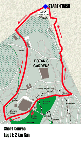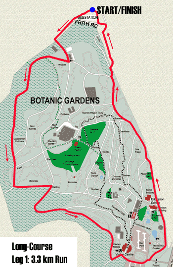
The first run course for the Long Course race starts from the transition area behind the ActewAGL substation at the end of Frith Rd, Acton. Follow Frith Rd, then turn left through the large gate into the National Botanic Gardens. Take your first right turn, into a steep climb for a few hundred metres. Continue on this outer perimeter road right around the top of the Gardens. Ignore all temptations to turn left into the main Gardens. When you come out beside the Visitors Centre, continue on the road towards the main exit from the Gardens, but turn left just before reaching the main entrance gate. You are now on the lower perimeter road.
Follow this road until there is a turn-off to your right through a gate onto a concrete walking track leading into the CSIRO. Turn off this track to your left onto an almost-invisible dirt walking track which brings you back to Frith Rd, which you follow back to the transition compound and prepare for the mountain bike leg.
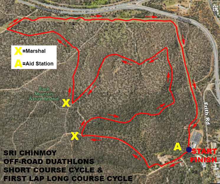
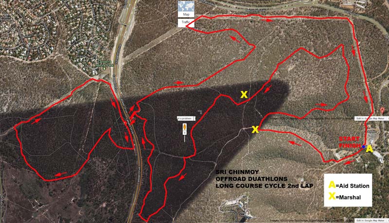
23 KM Cycle The mountain bike leg of the Long Course starts directly on Frith Rd. You will complete one short loop of 7 kms (the same as the Short Course mountain bike leg), followed by a longer 16 km loop.
Continue straight ahead on Frith Rd, through the large gate onto the dirt road. Turn right at the first fork, then left through the gate into Black Mountain Reserve. Follow this main dirt road uphill and turn right at the first opportunity. Ignore the next turn off to your left and continue to your right onto the fast, scenic loop around Little Black Mountain. After the hairpin turn to your left, do not take the first turn-off heading downhill to your right. Instead continue through a few small ups and downs, taking the next main turn to your right. Head downhill through a quite nice descent through eucalypts, continuing on this road all the way till you reach a T-junction. Go right here, up a slight rise. Turn right again before you reach Belconnen Way, continuing along the main track under the power lines. Follow this track all the way around to the transition compound, and continue directly into your second, larger loop.
click map for larger image
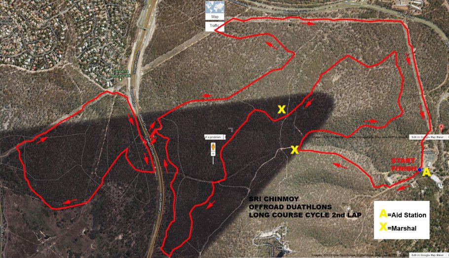
This is the same as the first loop all the way around the Little Black Mountain circuit. This time do not take the right hand turn into the sweeping downhill (there will be a marshal here to assist). Instead continue straight ahead on Callitris FT.
This track undulates around Black Mountain with the mountain on your left for several kilometres. Ignore the first turn up the hill to your left, but veer left (uphill) at the next fork, (Upper Woodland Trail) which brings you out onto a higher track, still heading around Black Mountain. When this track starts to descend, veer right (if you come to a dry creek bed leading into Push Bike Hill you have come too far!) You will come out onto an open grassy space (Lower Woodland Trail), adjacent to Gunghahlin Drive.
Continue on this track which is now heading north, following the line of the Gunghahlin Drive on your left. Re-enter the eucapylts and enjoy a relatively flat and easy riding section. Turn left onto the track heading under Caswell Dr and the Gunghahlin Drive. After the archway, turn left onto the track heading into Aranda Bushland. This track then loops around to the right, crosses a dry creek bed then turns sharply to the left into a fast, flat section. Take the right hand veer at the fork, then turn right under the power lines to head up a steep hill. At the top of this climb, turn left then right again to continue under the power lines. Go right, heading downhill at the next opportunity. Do not turn right into the steeper descent, but instead continue straight heading down towards Gunghahlin Drive.
Turn left at the bottom of the descent, and head back under the archway. Heading back into Black Mountain Reserve, turn left to resume on a fairly flat dirt road through the eucalypts. When you arrive at a T-junction, turn left (downhill) to find yourself once more on the original 7 km loop. Follow this loop as before until you reach the transition compound, and prepare for the final run.
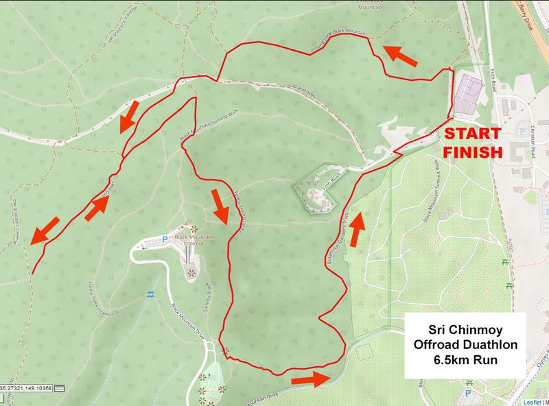
7 KM Run The final leg of the Long Course is a testing mountain run. THIS COURSE HAS BEEN REVISED IN 2020. NEW SECTIONS APPEAR IN BOLD. Head out from the compound back in the direction from which you just rode (the bike and run courses will be separated by bunting), then after a few hundred metres turn left onto a narrow walking track which climbs steeply uphill for about 300 metres before flattening out.
When this walking track reaches the main dirt road, turn left. You are now following the first part of the mountain bike course, but in reverse direction (all the bikes will have passed through here by now). Continue straight on this road, ignoring the first right hand turn, until you reach a T-junction. Turn right here, heading uphill. SHORTLY AFTER, TURN LEFT ONTO THE UPPER WOODLANDS TRAIL. FOLLOW THIS UNTIL IT JOINS THE WOODLANDS TRAIL, WHERE YOU TURN AROUND AND RETURN VIA THE SAME ROUTE UNTIL YOU REACH THE SUMMIT TRAIL. TURN RIGHT, HEADING DIRECTLY UPHILL UNTIL YOU REACH THE SUMMIT LOOP (FOREST TRACK), WHERE YOU TURN LEFT AND REJOIN THE OLD COURSE, enjoying your reward: some of Canberra's best views over a nice flat trail, though rocky in places. Just before this trail reaches the car park adjoining Black Mountain Rd, turn left onto a faint track that passes through a lookout point. After the lookout, look out for the trail heading down to your left, quite steep and rocky.
This descent brings you past a water tower on your left to another dirt road near its junction with Black Mountain Rd. Turn left here and follow this dirt road around the top of the Botanic Gardens. Eventually it brings you to a gate. Go through or over this gate. After 50 metres or so, turn right onto the lower dirt road. Pass through the big gate onto the bitumen road, then look for the finish line directly ahead.