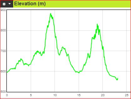
Leg 4: Cnr Majura & Phillip Ave (Dickson) to Rond Terrace, 23.1 km
NOTE DUE TO CONSTRUCTION AROUND THE WAR MEMORIAL, A DETOUR ROUND THESE WORKS IS NECESSARY. THE AMENDED COURSE APPEARS BELOW IN BOLD.
Download the complete navigable leg 4 course map, and leg 4 gpx file.
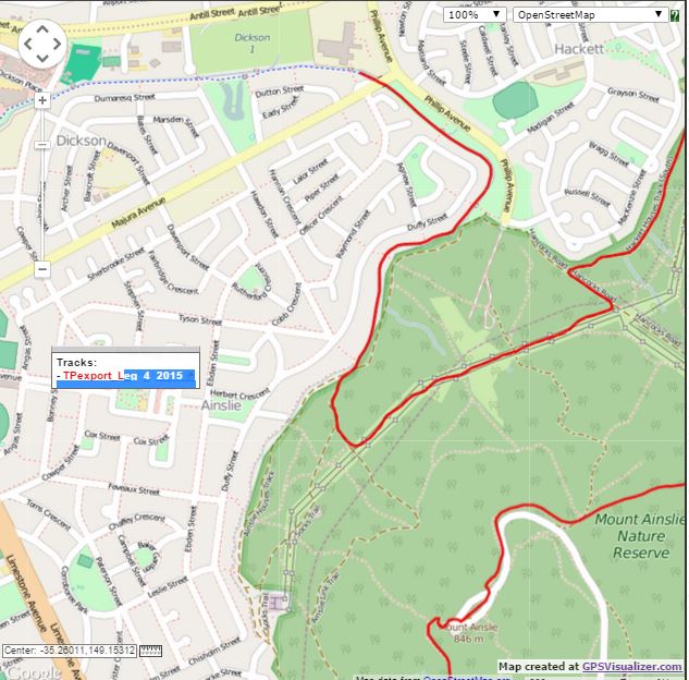
Continue east on the path from the transition area for 80m to cross Majura Ave at the RHS of the bridge and then follow the RHS of the canal along a dirt ST next to the houses of Ainslie. This track heads SE for approx. 500m then swings right to head SW/ W for 500m and then swings left once again (S) for just over 400m before you finally leave the houses track by turning left to cross the dry watercourse and 80m later take the left fork of the fire trail to head uphill into the trees on the Ainslie Link Trail. After about 200m keep left on the Ainslie Link Trail to climb 100 m up to an open area with large double powerlines and then turn left onto the large West 132KVA Track. Follow this for approx. 1.2K before the next major junction where you will turn left and head downhill on Hancocks Road for only 200m before turning right to follow the Hackett Houses track.
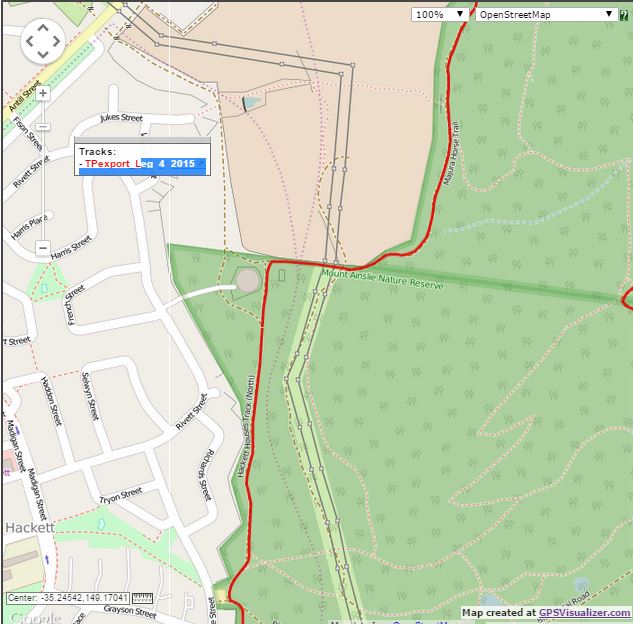
After about 1K follow this track as it zigs left (at intersection with Blue Metal Rd), zags right (now called Hackett Houses North track) and then climbs gently, directly straight ahead for about 700m (you pass on the RHS of the big water tank) before you turn right before the noticeboard to cross the logs and head uphill (E) on the Majura Horse trail. This trail climbs E and then swings N and after 500m crosses the Casuarina track.
A bit over 1K later you will continue straight on Majura Horse Trail as it intersects Oldfields Lane and then Clancy’s Walking Track. Approx 150m after Clancy’s Walking Track intersection you will turn right (uphill) to take the Mawson Majura Track, which heads E for about 230m and then swings left to the NE for about 120m before you come to a critical right turn (through hole in fence at white wire) to follow a set of powerlines along a clearing that takes you very steeply uphill on rocky terrain (no marked track, just follow powerlines).
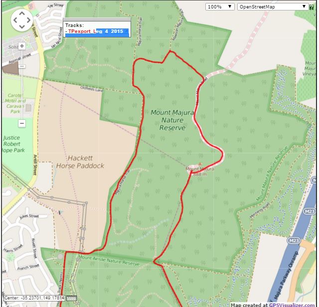
After approx 400m the powerlines lead you up to Mt Majura Rd where you will turn right to run all the way up to the First Drink Station just below the Majura Summit Trig. Take the dirt ST up to the Trig and retrace your steps past the Drink Station to head down through a gate to head steeply down the ridgeline fire trail heading S. After approx. 800m the trail flattens out and you will turn sharp left downhill (to the E) at the wooden bench seat and proceed for only 50m before turning sharp right (before the gate) at the “Mawson/Majura Track” sign to head steeply downhill on a very rocky ST descent. After 570m the descent brings you to an intersection with a Green Signboard and horse stile on your left. Continue straight ahead on the narrow ST as it heads uphill for 120m before it merges with the main fire trail coming up from your right. You will now follow this undulating trail as it follows the ridgeline over Hackett Hill with great views to the E and W as it heads mostly SW for approx 1.8 K until a T-junction with Hancock’s Rd.
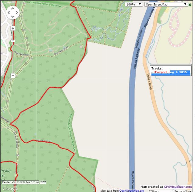
Turn left (E) and continue straight ahead at the saddle track intersection to continue heading down Hancock’s Rd towards the airport and Campbell Park. Now head downhill for approx. 1K on a long, smooth wide track. Turn right at the major trail intersection at the bottom of the hill onto Telecom Rd and then just under 200m later take the ST to the left that cuts the corner to merge with another main track heading E out towards the airport. This track swings right and then follows the fenceline on the edge of Campbell Park.

Stay on the main track as it temporarily veers away from the fenceline around a small dam. The track heads back into the trees and 120m later turns right (uphill) and turns into “Scotts Boundary Track”. Follow this track uphill, keeping the fenceline on your LHS. The track swings right past a “House Trail Link” sign. Approx. 400m later take the left fork in the track, which very soon intersects with a large cross road. Cross this road at the 4ft high cement post and immediately after crossing take the worn vehicle track heading off to the right at approx. 2 o’clock heading. This track swings left and starts to climb steadily uphill, hitting a clearing, passing under powerlines and then follows a single power line for about 140m before reaching a T-jn.
Turn right at the T-jn to take the wide dirt road heading uphill between the power lines. This road then descends steeply to cross a dry watercourse and then climbs quite steeply for about 200m. As the road starts to flatten out keep a lookout for an upcoming ST on your LHS that you will soon turn left at. This narrow ST soon climbs steeply and after 300m or so becomes wider and less steep. When this track merges with another road from the right you will travel only 40m before taking the right hand fork (BNT sign) at the track split onto some narrow ST. After 650m you turn left to climb a stone staircase and pass through a metal arch to reach Mt Ainslie Dr.
When you reach the road turn right (stay on the RHS) then head straight across Mt Ainslie Dr, heading straight up a dirt ST towards the Radio tower on the summit. At the tower take the steps back and down to the right to the road, cross straight across Mt Ainslie Dr onto a cobbled footpath (there is a water bubbler and tap and second drinks station to your left, just past the 1m high cement block). Continue straight ahead down some cement steps leading under the lookout and turn right around a metal barrier onto the main walking track. This sealed track passes some big steps and a lookout - 400m take care to stay on the main (sealed) track.
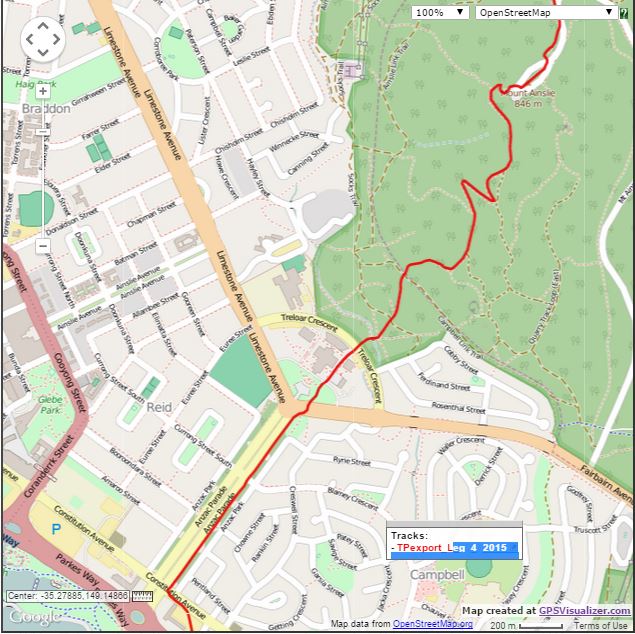
There are several sharp hairpin turns on the way down and you pass around 3 wooden corrals before passing a gate, a wooden footbridge and take 8 steps down onto a small dirt track that leads you to cross Treloar Cres behind the Australian War Memorial.
DETOUR HERE: TURN LEFT ALONG THE FOOTPATH ON THE LEFT HAND SIDE OF TRELOAR CRES, AND RUN ALL THE WAY ON THE LHS TILL YOU REACH THE MARSHAL. CROSS TRELOAR CRES AT THE MARSHAL WHO WILL BE STATIONED JUST BEFORE THE INTERSECTION WITH FAIRBAIRN AVE, THEN FOLLOW THE GRASS ALONGSIDE FAIRBAIRN AVE IN FRONT OF THE WAR MEMORIAL CONSTRUCTION FENCING, TO THE PEDESTRIAN CROSSING TRAFFIC LIGHTS. CROSS FAIRBAIRN AVE AT THE LIGHTS WHEN SAFE TO DO SO.
After crossing at the lights you will follow the footpath to your right which then heads along the LHS of Anzac Pde past various memorials. Take care when crossing Blamey Cres and Constitution Ave (course marshal) at the lights.
Turn left onto the footpath immediately after crossing Constitution Ave to follow it past the construction site till you reach Wendouree Drive.
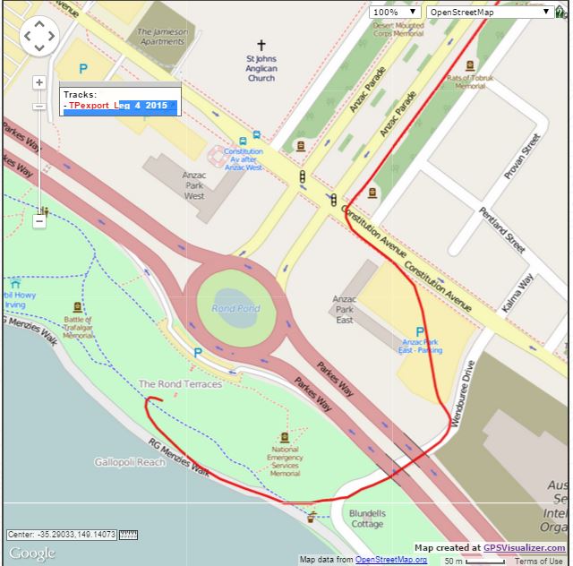
Turn right onto Wendouree Dr and cross over to the footpath on the LHS to pass under the two sections of Parkes Way. 70m later turn right to cross Wendouree Dr at the ped crossing and head down the path for 50m to turn right onto RG Menzies Walk near the Lake. Only 40m later take the bike path to the right to head up to Rond Terrace and the finish line chute on the grass.
Congratulations, you made it!