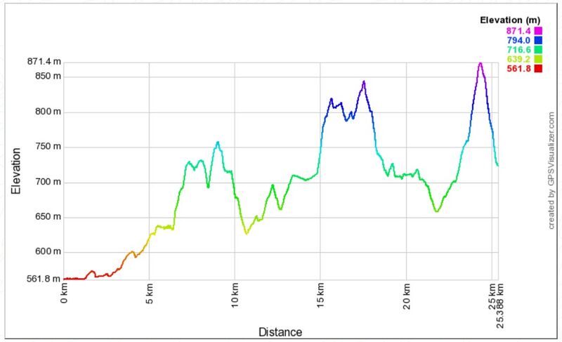
Leg 1: Rond Terrace to Waldock St, Mount Taylor north side, 25 km
Download the complete navigable leg 1 route map, and leg 1 gpx file.
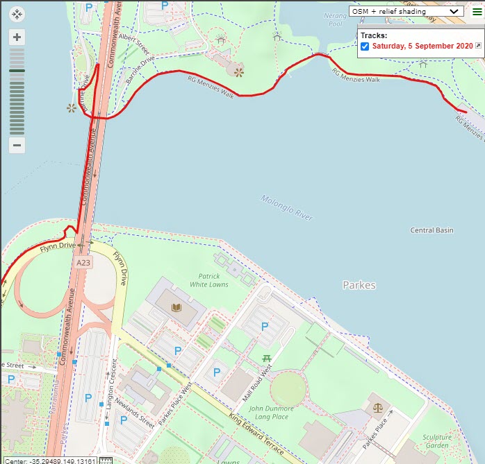
The start line is lakeside, in front of Rond Terrace on the North side of Lake Burley Griffin.
Follow the lakeside path (RG Menzies Walk) heading NW and then W towards, and then under Commonwealth Avenue Bridge (see detailed map, below).
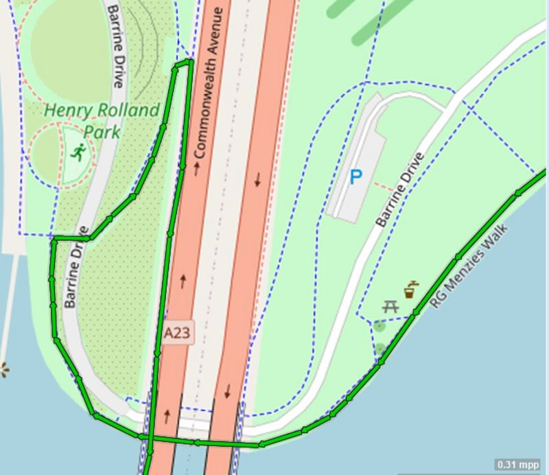
Before Henry Rolland Park, cross Barrine Drive, and follow the cycle path up the ramp onto the pedestrian pathway heading south across Commonwealth Avenue Bridge. Take the first R after the bridge onto the cycle path heading W alongside Flynn Dr.
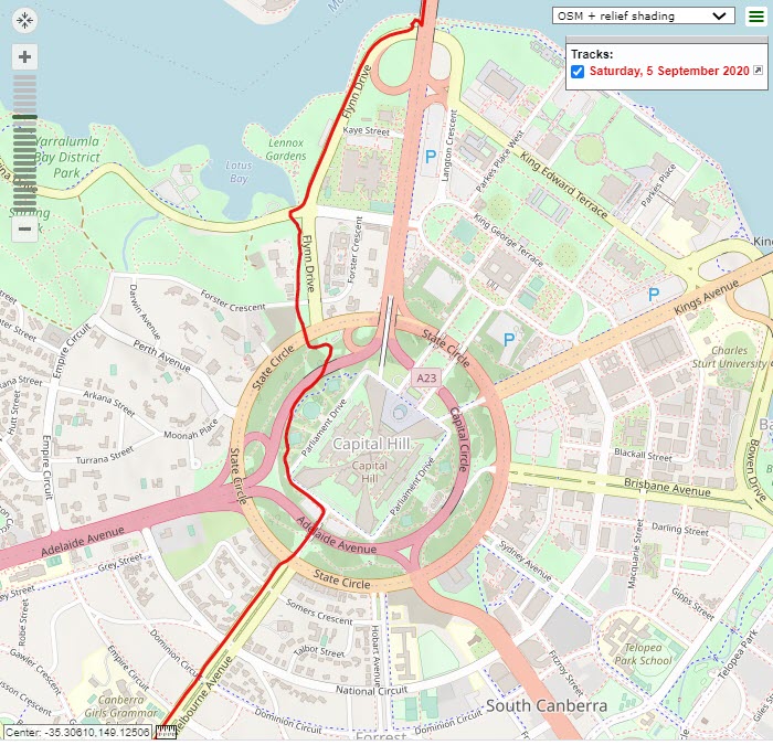
This path passes Nara Peace Park (toilets) then swings to the right near the roundabout (RDBT) after which you immediately turn left to cross Alexandrina Dr to follow the bike path up towards Parliament House. This path crosses Forster Cres, passes under 2 roads and then becomes narrow and climbs more steeply.
On the way up the hill turn right at the first path junction and then right again when you reach Parliament House to follow the grassy path on the right-hand side (RHS) of the road. After approximately 200m turn right at the first road (Melbourne Ave) to stay on the RHS footpath, which crosses a bridge over the road and leads down to a pedestrian crossing/lights at State Circle.
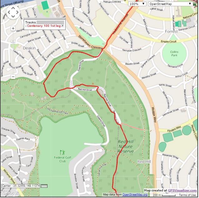
After crossing State Circle follow the footpath uphill on the RHS of Melbourne Ave, taking care crossing Somers Cres, National Cct, Dominion Cct, Empire Cct, and then Gawler Cres at the traffic island (at the end of Canberra Girls Grammar School), and head across to the RHS footpath towards Red Hill. After approx. 150m cross Stonehaven Cres at the RDBT to join the grassy verge on the RHS of Red Hill Dr. and then 130m later turn right immediately after crossing the bridge to join a dirt single track (ST) which then merges with the wider Deakin Reserve Fire Trail. After approx. 1K turn left at the Rutidosis Track sign to climb through a metal fence and then 20m later turn right to head steeply up the C. Russell Track.
Turn left at the next T-jn to continue uphill on a gravel road and then 100m later turn left again at the saddle track intersection to head steeply uphill once again. After passing through a metal stile take care crossing Gowrie Dr, head up the stairs and again take care crossing Red Hill Dr, entering the steps and dirt ST heading steeply uphill, which soon opens up to a right hand turn at a T-jn heading towards a radio tower. At the Red Hill Lookout Bay turn right towards the power pole to once again cross Red Hill Dr and then turn immediately left to join the dirt ST, which heads past the water tank reservoir and soon turns right and briefly down before climbing again along the fence line towards Red Hill restaurant, with expansive views of the Woden Valley opening up to your right. This track levels out near the public toilet next to Red Hill restaurant (toilet & water available), descends to a 6-way track at a saddle and continues straight ahead, up a steep climb, becomes sealed and then flattens out.
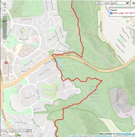
Near the top of the final climb detour left onto 30m of dirt ST to touch Davidson trig and then re-join the main trail again 50m later. Continue straight at the bottom of a short, steep descent as the track flattens and widens and becomes dirt again and after 200m or so take care to continue straight ahead to re-join the flat bitumen path.
The path then drops steeply down to a climb-through metal fence. Turn right onto the main Hindmarsh Track, staying near the fenceline for only 200m before turning 10 o’clock downhill onto a wide track that veers left after 200m (pedestrian detour) and narrows to single track running just beneath Hindmarsh Drive. After another 150m take care to veer right off this ST following the ribbon to your right, keeping the retaining wall behind the houses to your right. This will lead you down to the First Drink Station and a pair of large drainpipes on your left. Crouch down to go through the RHS drainpipe tunnel that takes you under Hindmarsh Dr. for approx. 60m.
Immediately after exiting the tunnel, turn *RIGHT* to climb up the earth bank and then drop down to join the footpath on the East side of the O’Malley houses. Stay on this path, taking the path that stays to the left of the playground, climb the stairs and head approx. 100m until the first street (Keyar St), where you turn left – staying on the footpath – to head down back towards the bush. After about 100m this path turns right and approx. 80m later look out for a metal gate on your left opposite house numbers 10 and 12 (flag pole). Turn left through this gate to follow a wide track that takes you uphill for about 700m (do not take any side tracks) where you come out into a second open area and turn hard right (change from heading East to SW) at the junction with another main trail (Centenary Trail). Follow this downhill onto a lovely single track cruising back into the forest towards the southern end of the O’Malley bushland, crossing a marshy area at the bottom and then starting a another climb heading SW.
After approx. 500m of steady gentle climb this track merges with a wider track from the left and 60m later you veer left (11 o’clock) onto a small access ST for 30m and turn left again at the T-jn (Equestrian sign) to head uphill. Follow this main track up the hill and then along the flat section above the houses in Isaacs for about 1.2K before entering the pines, taking care to stay on the left (higher) trail before turning hard left at the first equestrian sign then 40m later staying left at the fork to head very steeply uphill.
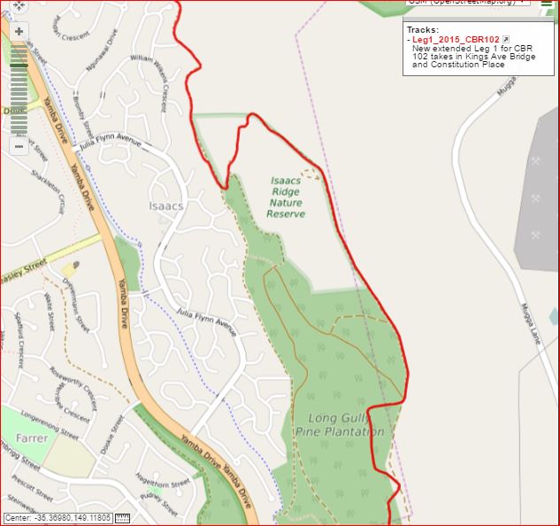
At the top of this steep pitch the track swings East while offering expansive views of the Woden Valley and beyond to the North, climbs gently to Sheaffe Trig and then follows the fence line along the ridge for approx. 1.2K.
Along the way you head down to a minor saddle, a small climb, and then descend to a major saddle where you merge with a wider road to continue heading uphill to your right. Just before the top of the climb take the right fork in the track to soon merge with the ridgeline track near the orange/white radio tower and then only 30m later turn right (downhill) onto a fire trail which heads down into the pines. After 400m or so this trail turns right and drops very steeply for about 300m before swinging hard right again along a gentle descent between the pines. Turn left (downhill) 300m later at the next intersection and follow this for only 100m before veering right to join 40m of dirt ST that cuts the corner to join another equestrian track heading right towards Shepherdson Pl.
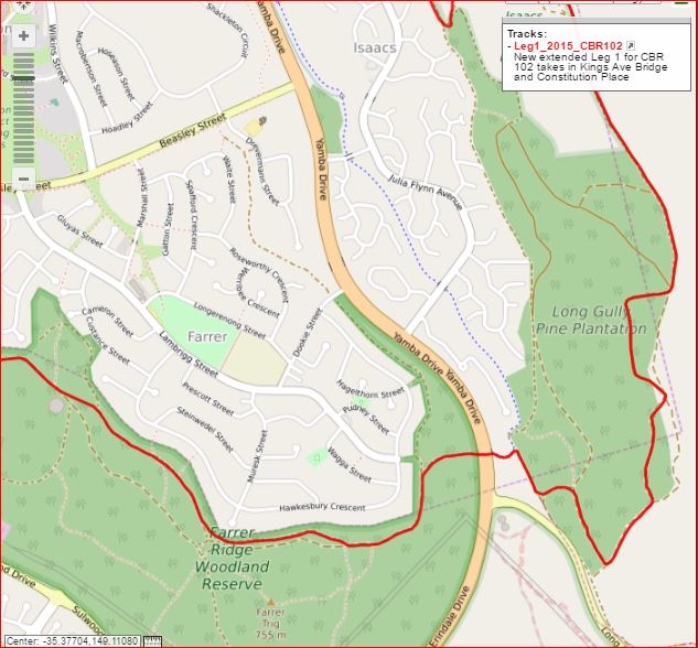
After 200m turn left to take the sealed path uphill to pass under Yamba Dr. – approx. 50m later veer left uphill off this track at approx. 10’o clock heading to pass a wooden fence and continue straight through to a very rocky 200m stretch of track which swings left and downhill towards the houses at Farrer. Turn left onto the track behind the houses and after 500m or so take care to stay on the right, lowest, flat track (2 o’ clock heading) that stays closest to the houses. A bit over 500m later when the main track turns left you can cut the corner to the right following 80m of ST which then merges with another main track that heads roughly parallel to the Farrer houses. About 600m further on you should bear left at the fork in the track (equestrian sign) to head away from the houses. This track starts to descend past the RHS of the water reservoir and soon after turns left, heading straight towards Mt Taylor and downhill to cross some wooden equestrian stiles to arrive at the 2nd drink station on the eastern side of Athlon Dr. This is the largest and most dangerous road crossing of the race and you MUST obey the road marshals’ instructions as to when you can cross both double lane sections.
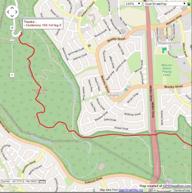
After crossing Athlon Dr you cross a bike path, go through a gate near a stile and continue directly uphill on the Torrens Houses fire trail (FT). A bit over 1K later (near the corner of the housing line on your right) turn left, uphill, at the Mrs Low’s FT sign to pass through a gate, and 70m later turn right before the tourist information board to head steeply uphill on the track that leads up Mt Taylor. This narrow track passes several lookout chairs that offer great views of the Tuggeranong Valley and the Brindabella Mountains before becoming stepped and steeper and then opens out to a wider road that soon turns right and climbs very steeply towards the radio tower. At the top of this steep climb veer right onto 60m of rocky ST that takes you to the Mt Taylor trig and then 60m back left to re-join the main FT heading North, which drops gently, turns to bitumen, and then drops very steeply, offering a dramatic view to the North. The road briefly turns back to dirt and temporarily flattens out before swinging left (West) and dropping steeply once again on a 100m bitumen section. Turn right (2’o clock) immediately at the end of this bitumen section onto a dirt track and 100m later bear right at the fork, continuing 90m to the Transition station just above the steps leading down to the Waldock St (dead end) car park.