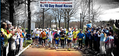


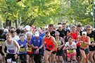
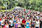
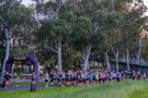
Sri Chinmoy Canberra Time-Trail Runs
What is a Time-Trail Run? – a time-trial run on trails! The crowds are virtual, but the running and the competition are real...
About the event
The Sri Chinmoy Marathon Team is facilitating solo trail runs (or walks) at popular venues close to Canberra, staged as individual time-trial races.
No crowds or supporters and no officials will be in attendance.
Participation is free. Entry is online only.
Event Overview
Each event will be staged within a 7-day timeframe. Runners must navigate the course, time their own run, and upload their race time to the event portal. Photos, including selfies, can be submitted for the event photo gallery. Times will be collated and full results and photo gallery published, with awards for age group winners for each race and downloadable Finisher's Certificates for all.
Course Navigation
All courses are unmarked. Please study the course maps and descriptions carefully. If you can, we strongly advise you download the gpx files to assist with course navigation.
Distance Options
Each event includes 3 distance options. Runners may only enter ONE distance:
* Short (1.8km – 2.2km)
* Middle (5km – 10km)
* Longer (10km – 31km)
Race rules
1. Please keep outside of current social distancing requirements of 1.5m of all other persons.
2. The events may be run solo or in a private group up to 20 runners.
3. Remember path and trail etiquette. Keep to the left, respect all other path users, and let people know you are passing.
4. Only one time can be submitted and accepted as a result for each participant. Your first submitted result is final.
5. Each runner can only enter one distance event.
6. We recommend that children under 12 be accompanied by an older family member.
Race Two – Sri Chinmoy "Stromlo Strides"
Please see course description below.
Online entry for the "Stromlo Strides" is now CLOSED.
The event officially opened for participation at 7pm on Friday 29 May.
Online entry for the "Stromlo Strides" closed at 7pm on Tuesday 2 June.
The deadline for submission of race times and photos is 7pm on Friday 5 June.
To Submit Your Race Time
Upon completion of entry, runners will receive a confirmation email, followed WITHIN 48 HOURS by a second email containing a link to submit their Race Time, Date of Attempt and Start Time directly into the Race file. Please take care not to delete this email until you are satisfied that your result is online (check here once you have uploaded your time).
Only ONE uploaded result is allowed for each race. Runners may have multiple attempts during the week but the one that is first uploaded via the email link will be the runner's official timing.
Please note that you should only upload your Total Time, not Moving Time from GPS programs like Garmin Connect and Strava. In Strava the event should be classified as a "Race", which only accepts "Elapsed Time" not "Moving Time". This is a race, which starts when you depart the Start line and concludes when you reach the Finish line – any stopped time for photos or navigation errors is counted. Podium winners should be prepared to be asked for their Strava traces or Garmin traces and Elapsed Times if required.
To Upload Your Photo
Scroll down on this page till you find the button to upload your race photo (under the course descriptions). If you wish to submit more than one photo, please send them directly to [email protected]. Photos must be submitted by 7pm Friday 5 June. The event photo album will be published on Saturday 6 June.
A prize will be awarded for the Best Race Photo for each event.
Check who your competitors will be, on the list of current entrants.
Previous results
Events
2km
-
- Free entry, online only
6.3km
-
- Free entry, online only
- View course map »
15.4km
-
- Free entry, online only
Contact
Prachar Stegemann 0404 071 327
 Send Email
Award categories
- Awards for age group category winners
- Award for best race photo
- Personalised, downloadable Finisher's Certificates for all
Race Details
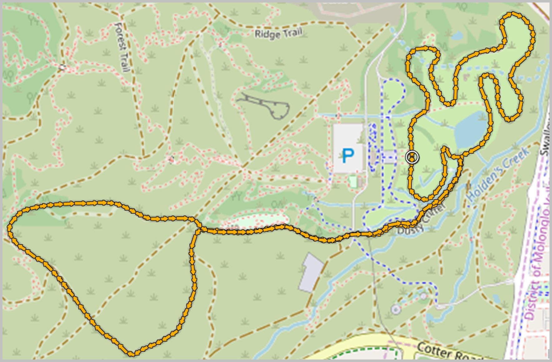
Sri Chinmoy "Stromlo Strides"
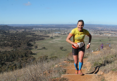
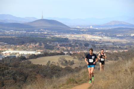
The second race of the Series increases the distances and moves to Canberra's all-purpose world-class Stromlo Forest Park – like Canberra itself, the perfect blend of natural beauty with man-made ingenuity. The "Novice" course follows the purpose-built "Deek's Track" cross-country running course; the moderate-grade 6.3km course ventures out to the majestic Blue Gums; while the longer 15.4km route ascends the summit of Mt Stromlo before rambling a loop around the shoulder of the mountain.
Note this race is held over a one-week timeframe – from 7pm Friday 29 May to 7pm Friday 5 June.
Park at the Stromlo Forest Park car park at the end of Dave McInnes Drive.
Online entry for this race is now CLOSED. Entry is free.
Download the gpx file for the 2km Novice course; view the route map and elevation profile or download the gpx file for the 6.3km course; view the route map and elevation profile or download the gpx file for the 15.4km course.
Read the full course description and take a photo tour of the courses.
The Courses for the Series
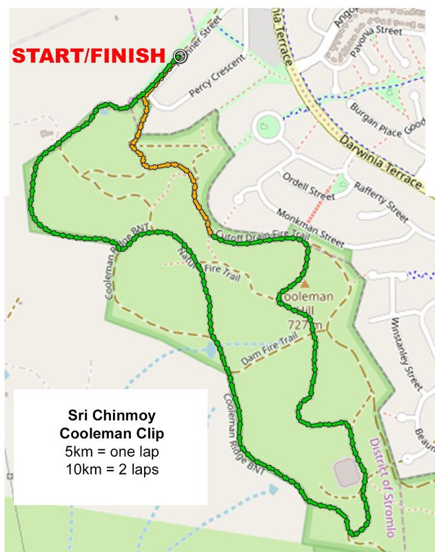
- "Cooleman Clip" 1.8km & 5km
- "Stromlo Strides" 2km, 6.3km
- "Stromlo Strides" 15.4km
- "Tuggeranong Trot" 2km & 8km
- "Tuggeranong Trot" 20km
- "Gungahlin Gallop" 2.2km, 10km
- "Gungahlin Gallop" 31km
For the 1.8km course, view the course map, elevation profile and download the gpx file.
For the 5km course, view the course map, elevation profile and download the gpx file (the 10km course = 2 laps of the 5km course).Take a photo tour of both courses.
Introduction
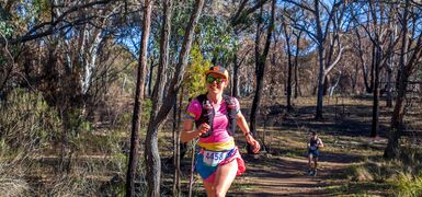
Cooleman Ridge has been a routine stamping ground for Canberra runners since Weston Creek was established in the 1960s. Everyone knows the main track behind the houses, but not all are familiar with the intricate network of fire and single trails that criss-cross up, down, along and around this remarkable natural haven.
Testing uphills (including some stairs), pockets of bushland, an abundance of birds, sweeping vistas in all directions – over South Canberra towards Telstra Tower and across the Bullen Range towards the Brindabellas – make this run a perfect advertisement for Canberra trail running.
Novices & Kids 1.8km
We recommend children be accompanied by an adult.
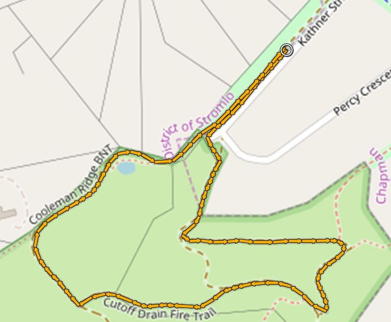
The Start/Finish point is on the dirt track across the road, directly opposite the North end of the white cement driveway of 25 Kathner St. A spray paint mark "S" on the gutter on the grassy side will show you where it is.
You can also use your phone or GPS watch to enter the following DDM coordinates which you can also type into Google Maps as follows: -35.348381 149.025179Head SW on the dirt track alongside Kathner St towards Cooleman Ridge and after 180 m (0.18) turn left at the fence and then right (0.22) through the gate to climb up the dirt hill up towards Cooleman Ridge.
The climb changes from dirt to bitumen and to dirt again before swinging to the left about HALFWAY (140m) up the hill, at which point (0.36K) you will turn LEFT to take the flat FT that contours around the hill behind the houses. After about 240m (0.60) the trail swings uphill to the right and then merges (0.61) with a larger FT heading up to the Ridge.At the top of the climb (0.74) turn RIGHT onto the Cutoff Dam FT, taking care after 160m (0.90) to bear left, staying on the same FT. This trail descends to the W, giving sweeping views of the Brindabella Mountains straight in front of you. After 240m (1.14) turn right at the T-junction to head downhill on the Cooleman Ridge FT, following it for 460m all the way to the horse stiles at the S end of Kathner St (1.60) and continue straight ahead for another 180m to the Start/Finish line.
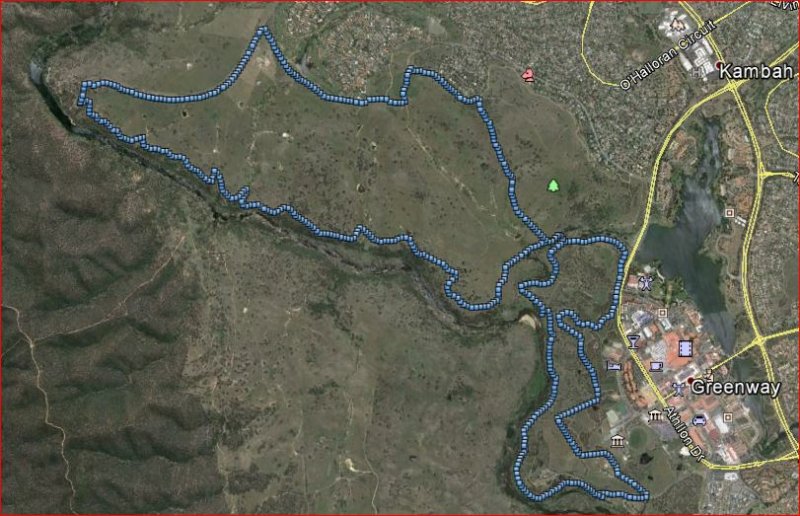
5km (10km is 2 laps of the 5km course)
The Start/Finish/Lap point is on the dirt track across the road, directly opposite the North end of the white cement driveway of 25 Kathner St. A spray paint mark "S" on the gutter on the grassy side will show you where it is.
You can also use your phone or GPS watch to enter the following DDM coordinates which you can also type into Google Maps as follows: -35.348381 149.025179
Head SW on the dirt track alongside Kathner St towards Cooleman Ridge and after 180 m (0.18) turn left at the fence and then right through the gate to climb up the dirt hill up to Cooleman Ridge.
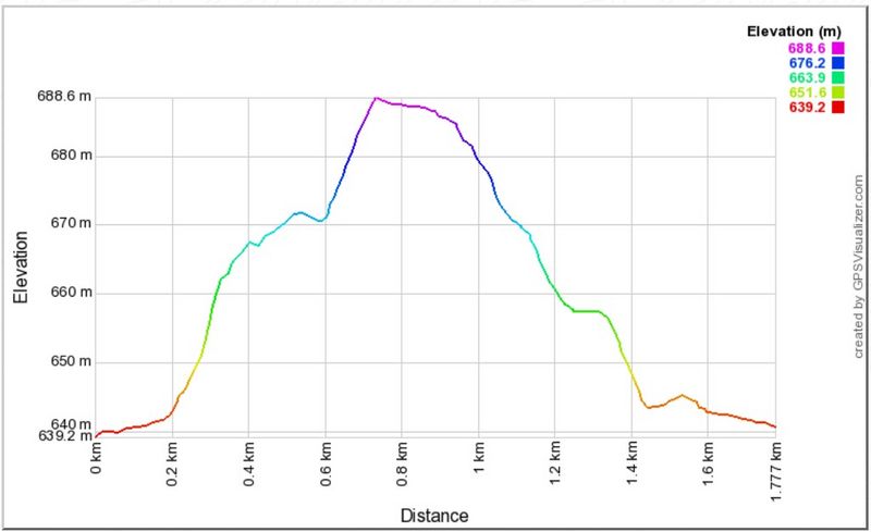
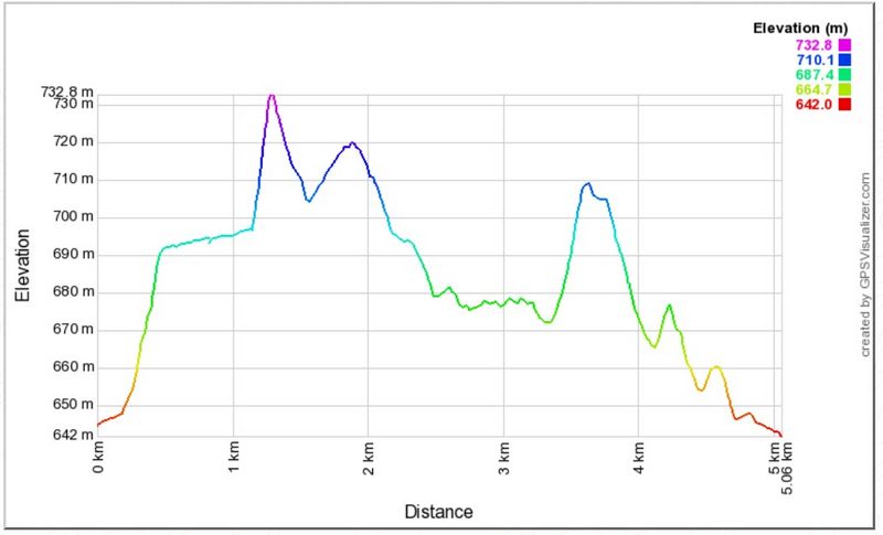
At the top of the climb (0.47) stay on the main fire trail (FT) to the left with expansive views of Weston Creek and Canberra to your left. After another 700m (1.15), turn sharp right across the metal footbridge to climb the steps up a single track (ST) that ascends steeply to Cooleman Hill Trig. At the top of the climb (1.28) do not turn left to the Trig but veer to the right and follow the ST down the other side of the hill until you meet a larger trail T-junction, at which you will turn left (1.41) onto the Nature FT. Follow this South, crossing the intersection with Dam FT (1.57) to follow the lovely ST past the Lookout (1.91), and then descending to see a large water tower on your right at which you will turn right (2.28) onto Darryl Place FT, taking care after 40 m to take the LEFT branch that heads down the hill.Climb through the fence (2.45) and 50m later (2.50) turn right (N) to take the Cooleman Ridge FT for approximately 800 m until just after a Dam (on your left) when you will turn right off the main FT (3.35) continuing straight ahead to follow a big grass trail that climbs steeply up to the north for 270m. This brings you out at a T-junction with Nature FT, where you will turn left (3.62), heading NW along the ridge for approx. 180m climb before clambering through the fence and turning LEFT (3.80) onto the Cooleman Ridge Bicentenary FT to head downhill for only 130m before turning sharp RIGHT (3.93) to follow a small grassy single track, that follows the fence line for approximately 500 m – first heading W and then swinging to the N until you rejoin the main FT (4.54). Follow this FT, descending to reach the horse stiles at the S end of Kathner St (4.88) and continue straight ahead for another 180m to the Start/Finish line (5.06).
5K runners are finished, 10K runners turn around at the Start and repeat the 5K loop for a second lap.
Download the 2km gpx file; view the 6.3km course map and elevation profile, and download the gpx file.
Take a photo tour of the route (includes the 15.4km course).
Introduction
A phoenix which grew from the ashes of the catastrophic fires of January 2003, Stromlo Forest Park is a superb testimony to the vision and optimism of a Canberra’s leaders of that time. A world-class recreational precinct adjacent to urban Canberra, the Park both inspires and fulfils the tastes and needs of Canberra’s highly skilled, adventurous and discerning athletic public.
Utilising the man-made resources of “Deek’s Track”, the purpose-built cross-country running track alongside numerous equestrian and fire trails exploring the various terrains and ecosystems inhabiting the scenic slopes and summit of Mt Stromlo itself, three courses of varying distance offer a spectrum of personal challenges and enjoyments.
2km Novice Course
The route is one clockwise lap of “Deek’s Track”, starting and finishing at the "Start/Finish" sign in front of the Stromlo Forest Park pavilion. This coure excludes the optional “Hill Loop”, but does include the “Creek Loop”.
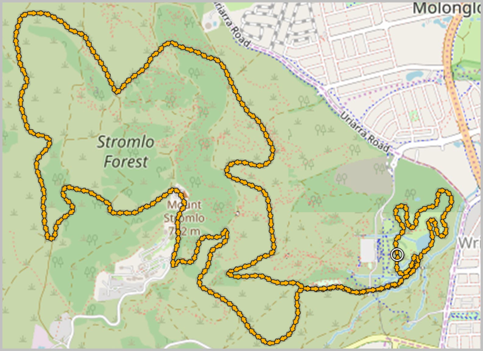
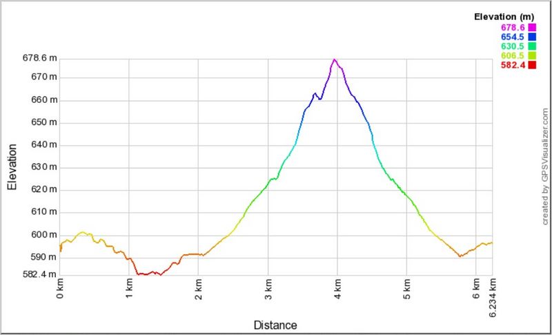
6.3km course
The 6.3km race, starting and finishing at the "Start/Finish" sign, starts with a near-complete clockwise circuit of “Deek’s Track” cross-country running course, including the optional “Hill Loop” (without the furthest little steep hill extension) and the “Creek Loop”.
After about 2km (2.06), just after the track passes a large pond on the right, the route turns L (left) onto a small single track just prior to a culvert, and then veers R (right) after a further 80m to merge with a wider track running parallel with a creek on the L, and around the end of the criterium track on your R.
After 400m (2.54) this track becomes briefly bitumen. Pass around the metal gate, cross a bitumen road and continue onto the main dirt road leading straight ahead and slightly uphill. Pass “The Playground” mountain bike test trails course on your R.
500m along this track (3.05), turn L at a large intersection, then continue straight (avoid the left hand veer) after a further 110m. This trail rises and curves around to the right, gently climbing the hip of Mt Stromlo, before dipping again to reveal the summit directly ahead. Continue on what is now “Ridge Trail”, which climbs briefly and dips again, passing a few cross-roads until after about 1km (4.10) reaching a major intersection with a stand of Blue Gums on the right.
At this juncture, the Long (15.4km) Course continues ahead uphill towards the summit, while the Middle Distance (6.3km) Course turns right and downhill into the Blue Gums. After 200m among the majestic gums, the Long Course track again rejoins from the L. Both courses now follow the same route, downhill out of the Blue Gums, past some picnic tables and then a toilet block on the R, then the original turn-off point on the R.
You are back on the same course as your outbound route, now following it in reverse and downhill, past “The Playground” this time on your L, across the bitumen road, through the metal gate, past the end of the criterium course and along the narrower single track to rejoin “Deek’s Track” cross-country course at the point where you left it. Turn L here and complete “Deek’s Track” clockwise to the finish, opposite the Stromlo Forest Park pavilion.
View the 15.4km course map and elevation profile, and downlad the gpx file.
Take a photo tour of the route.
Introduction
A phoenix which grew from the ashes of the catastrophic fires of January 2003, Stromlo Forest Park is a superb testimony to the vision and optimism of a Canberra’s leaders of that time. A world-class recreational precinct adjacent to urban Canberra, the Park both inspires and fulfils the tastes and needs of Canberra’s highly skilled, adventurous and discerning athletic public.
Utilising the man-made resources of “Deek’s Track”, the purpose-built cross-country running track alongside numerous equestrian and fire trails exploring the various terrains and ecosystems inhabiting the scenic slopes and summit of Mt Stromlo itself, three courses of varying distance offer a spectrum of personal challenges and enjoyments.
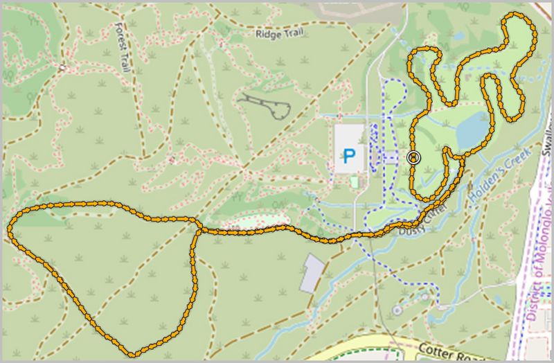
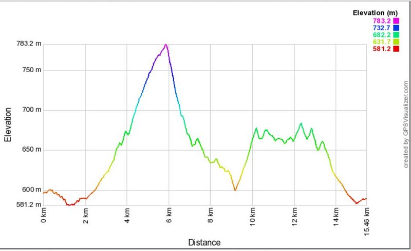
15.4km Course
The 15.4km race, starting and finishing at the "Start/Finish" sign commences with a near-complete clockwise circuit of “Deek’s Track” cross-country running course, including the optional “Hill Loop” (without the furthest little steep hill extension) and the “Creek Loop”. After about 2km (2.06), just after the track passes a large pond on the right, the route turns L (left) onto a small single track just prior to a culvert, and then veers R (right) after a further 80m to merge with a wider track running parallel with a creek on the L, and around the end of the criterium track on your R.
After 400m (2.54) this track becomes briefly bitumen. Pass around the metal gate, cross a bitumen road and continue onto the main dirt road leading straight ahead and slightly uphill. Pass “The Playground” mountain bike test trails course on your R.
500m along this track (3.05), turn L at a large intersection, then continue straight (avoid the left hand veer) after a further 110m. This trail rises and curves around to the right, gently climbing the hip of Mt Stromlo, before dipping again to reveal the summit directly ahead. Continue on what is now “Ridge Trail”, which climbs briefly and dips again, passing a few cross-roads until after about 1km reaching a major intersection with a stand of Blue Gums on the right. At this juncture (4.10), the Long (15.4km) Course continues ahead uphill towards the summit, while the Middle Distance (6.3km) Course turns right and downhill into the Blue Gums.
The 15.4km route heads up the front of the mountain, sweeping to the R for 600m before taking a L hairpin turn (4.71) and continuing to rise a further 600m (keeping to the R hand option at a fork just prior to the metal gate) until the bitumen Mt Stromlo Rd is reached (5.32). Turn R onto the verge on the RH side of the road (do NOT run on the road please). After 300m along the road verge, continue onto the lesser bitumen road straight ahead, where the main road turns L in front of the burned-out ruined observatory (water refill possible here at 5.60km).
Pass the Mt Stromlo summit trig on your R (5.88) and the Satellite Laser Ranging Facility on your L. A further 300m along, pass around the metal gate where the bitumen ends, continuing onto the dirt track straight ahead, now heading downhill, staying L at the fork and passing another metal gate (5.96). Extensive views across to the Brindabella Range now open up as you descend steeply for 500m, turning R (6.40) at the T-junction and then L after a further 100m (6.50) now heading down and away from Mt Stromlo.
Descend a further 360m before turning L (6.86) at the next T-junction of Stromlo Pipeline Rd, which bends after a while gently right, then left. 500m further along, turn R at the gate bearing the sign “Space Weather Monitoring Site”(7.38), then R again after 40m (7.42) onto the Cooper Fire Trail, which curves gracefully along the valley for 1.8km. Watch out for wallabies and rabbits! Take the next available R turn (9.23km, before arriving at the next gate), now heading back uphill towards Mt Stromlo.
Climb this track for 500m, pass through a gate (9.67), cross straight over a 4-way intersection with Stromlo Pipeline Rd, to continue onto the Mountain View Track, climbing for another 500m till you meet and turn L (10.17) at the major T-junction of Forest Trail.
Stay on Forest Trail, ignoring all potential side tracks and trails, as it winds around and along the flank of the mountain for 2.8km.
Forest Trail ends at a T-junction with Ridge Trail(13.05). Turn R here and continue 400m into the Blue Gums, where you will turn L again at the next T-junction (13.45) to rejoin the Middle Distance (6.3km) course.
Run downhill out of the Blue Gums, past some picnic tables and then a toilet block on the R, then the original turn-off point on the R. You are back on the same course as your outbound route, now following it in reverse and downhill, past “The Playground” this time on your L, across the bitumen road, around the metal gate, past the end of the criterium course and along the narrower single track to rejoin “Deek’s Track” cross-country course at the point where you left it. Turn L here and complete “Deek’s Track” clockwise to the finish, opposite the Stromlo Forest Park pavilion.
View the 2km course map, the 8km course map in satellite view or map view, and the start/finish area.
Take a photo tour of the course (includes 20km course).
Introduction
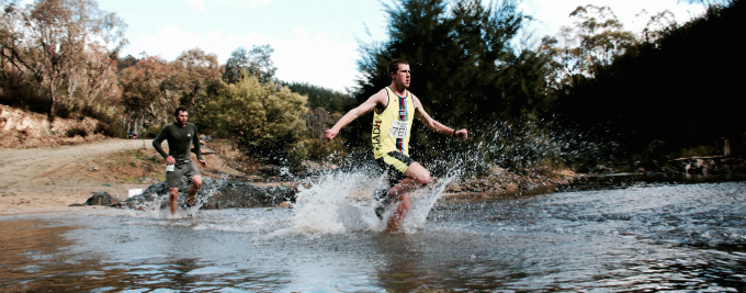
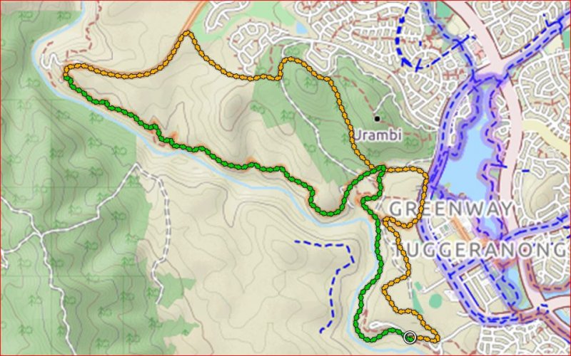
Pine Island Reserve is located on Pine Island Road in Greenway, just minutes from Tuggeranong. Such easy access to the banks of the Murrumbidgee is a real advantage for Canberrans. There is a playground for the kids, free electric barbecues, clean toilet facilities and picnic tables.Pine Island is the perfect starting point for the second race in the Sri Chinmoy Trail Series as it is linked with parts of the Bicentennial National Trail and Canberra Centenary Trail as well as the Murrumbidgee Discovery Track. You will get to run/walk through a superb mixture of native forest and farmland, while those doing the longer option up to Kambah Pool will get great views of the Brindabellas and the Bullen Range as well as experience Red Rocks Gorge, one of the most spectacular gorges along the whole Murrumbidgee River. Both courses pass by the historic Tuggeranong dry stone wall, built in the 1860s to mark the boundary between two early rural properties.
2km "Novice" Course
The start is on the W (playground) side of the yellow locked gate at the N end of the Car Park on the grass. Cross the grass to join the dirt path heading S past the playground, past the toilet block (0.27), and cross a wooden bridge (0.43). After just over 700m you leave the single track to cross a grassy area (follow the cones) between the trees for approx 200m (0.88K) before taking a small grass track through to a 2nd grassy area where you run for just over 100m before turning back around a cone at the brown timber picnic table (1.03K) and retracing your steps back towards the start. To finish you will keep heading N up the dirt path past the Finish line and then approx 60m later turn right after the trees and right again to head into the Finish chute heading S (2.00K).
8km Course
The race starts on the grass next to the locked gate at the W end of the Pine Island N Car Park.
Staying on the grass, follow the boulders all the way along the road heading back towards the Car Park entrance for approx. 440m (0.44) before turning left to pass through onto the Bicentennial National Trail. Here you will follow a wide grassy track keeping the fenceline to your left. After another 600m or so (1.0) the trail turns left and heads W at the Tuggeranong Archery Range and then 200m later (1.22) turns right (NW), staying near the fenceline. Another 350m later the track turns right (1.57, NE), with a Dam appearing on your right after 300m or so (1.87), soon after which you will turn left through a gate to rejoin the Bicentennial National Trail (1.94) heading N.
Follow this track for about 500m before taking care to turn left at the fork in the track (2.48) to head NW. After another 300m or so(2.77), turn right at the T-junction to head uphill towards Tuggeranong Town Centre. Climb through the fence (3.3) to take the narrow dirt track up onto the bike path on Athlon Drive (3.41), which you will only follow for approx. 170m (3.58) before veering off onto the dirt road on your left heading towards Tuggeranong Creek. This will take you through a gate (3.72) and then gradually start to curve to the left (3.86) to run parallel with the Creek.
Soon you will reach the Drink Station (4.41) and continue straight ahead to soon pass through a gate (4.48) and make a short climb. Turn left at the fork and continue climbing before descending on grassy/rocky tracks to meet the Murrumbidgee Discovery Trail (MDT) next to Tuggeranong Creek at about the 5K mark. Continue on this trail, ignoring all side tracks. Follow the MDT through a gate at the Tuggeranong Stone Wall (5.44), taking care only 80m later (5.52) to turn right off the large track and onto the narrow MDT which stays low and runs parallel to the Creek.
This delightful piece of single track takes you on a scenic journey along the Creek and eventually brings you out at the finish at Pine Island N on the grassy area near the playground and BBQ areas (8.03).
View the 20km course in satellite view or map view; and the start/finish area.
Take a photo tour of the course.
Introduction
Pine Island Reserve is located on Pine Island Road in Greenway, just minutes from Tuggeranong. Such easy access to the banks of the Murrumbidgee is a real advantage for Canberrans. There is a playground for the kids, free electric barbecues, clean toilet facilities and picnic tables.Pine Island is the perfect starting point for the second race in the Sri Chinmoy Trail Series as it is linked with parts of the Bicentennial National Trail and Canberra Centenary Trail as well as the Murrumbidgee Discovery Track. You will get to run/walk through a superb mixture of native forest and farmland, while those doing the longer option up to Kambah Pool will get great views of the Brindabellas and the Bullen Range as well as experience Red Rocks Gorge, one of the most spectacular gorges along the whole Murrumbidgee River. Both courses pass by the historic Tuggeranong dry stone wall, built in the 1860s to mark the boundary between two early rural properties.
20km Course
The 20km course is the same as the 8km course but diverges at the drink station at 4.41km to add on another 12km loop by heading up to Kambah Pool via the back of Urambi Hills and the back of the Gleneagles Golf Course, returning to the same drink station via the beautiful trail along the Murrumbidgee through Red Rocks Gorge.The race starts on the grass next to the locked gate at the W end of the Pine Island N Car Park.
Staying on the grass, follow the boulders all the way along the road heading back towards the Car Park entrance for approx. 440m (0.44) before turning left to pass through onto the Bicentennial National Trail (BNT). Here you will follow a wide grassy track keeping the fenceline to your left. After another 600m or so (1.0) the trail turns left and heads W at the Tuggeranong Archery Range and then 200m later (1.22) turns right (NW), staying near the fenceline. Another 350m later the track turns right (1.57, NE), with a Dam appearing on your right after 300m or so (1.87), soon after which you will turn left through a gate to rejoin the Bicentennial National Trail (1.94) heading N. Follow this track for about 500m before taking care to turn left at the fork in the track (2.48; Course Marshall) to head NW. After another 300m or so, (2.77) turn right at the T-junction to head uphill towards Tuggeranong Town Centre. Climb through the fence (3.3) to take the narrow dirt track up onto the bike path on Athlon Drive (3.41), which you will only follow for approx. 170m (3.58) before veering off onto the dirt road on your left heading towards Tuggeranong Creek. This will take you through a gate (3.72) and then gradually start to curve to the left (3.86) to run parallel with the Creek. Soon you will reach the Drink Station (4.41)
At the Drink Station turn right down the steps to cross a bridge across Tuggeranong Creek and follow the trail downhill for 200m before turning right at the fence (4.61) to climb up behind Urambi Hills. You will steadily climb for almost 1.4K before the track reaches a fence, where you will turn left (6.0) to rejoin the BNT heading W towards the mountains. The BNT continues to climb behind the houses at the S end of GlenEagles to pass through a gate (6.43) and then starts to descend, opening up great views of the Bullen Range and Brindabella Mountains. Approx. 500m later (6.69) turn left at the T junction near the tree to stay on the BNT and head downhill on a wide fire trail for about 300m before it turns right (6.97) to head down to follow the edge of the houses (7.34) and then the edge of the GlenEagles Golf Course (7.58), eventually climbing (8.28) up to Kambah Pool Rd (8.49) where you will turn left to head towards the Mountains and Kambah Pool. Follow the single track that runs parallel to the road all the way down to where it eventually joins Kambah Pool Rd (10.32). Take care here to stay on the far left edge of the road for only 200m as it steeply descends before turning left at the drink station to join the Murrumbidgee Discovery Track and the Canberra Centenary Trail (10.51). You will now follow this single track for approximately 6K, taking in the wonderful scenery of Red Rocks Gorge and then heading back out into farmland and bushland leading back to Tuggeranong Creek, where you will cross the bridge in the other direction and head up the steps to the original drink station at the start of this big loop (16.57).
Turn right at the drink station and then continue straight ahead to soon pass through a gate (16.62) and make a short climb before descending on grassy/rocky tracks to meet the Murrumbidgee Discovery Trail (MDT) next to Tuggeranong Creek at about the 17.2km mark. Follow the MDT through a gate at the Tuggeranong Stone Wall (17.56), taking care only 80m later (17.64) to turn right off the large track and onto the narrow MDT which stays low and runs parallel to the Creek. This delightful piece of single track takes you on scenic journey along the Creek and eventually brings you out at the finish at Pine Island N on the grassy area near the playground and BBQ areas (20.19).
View the 2.2km course map, the 10km course map, and start/finish area.
Take a photo tour of the course (includes the 30km course).
Introduction
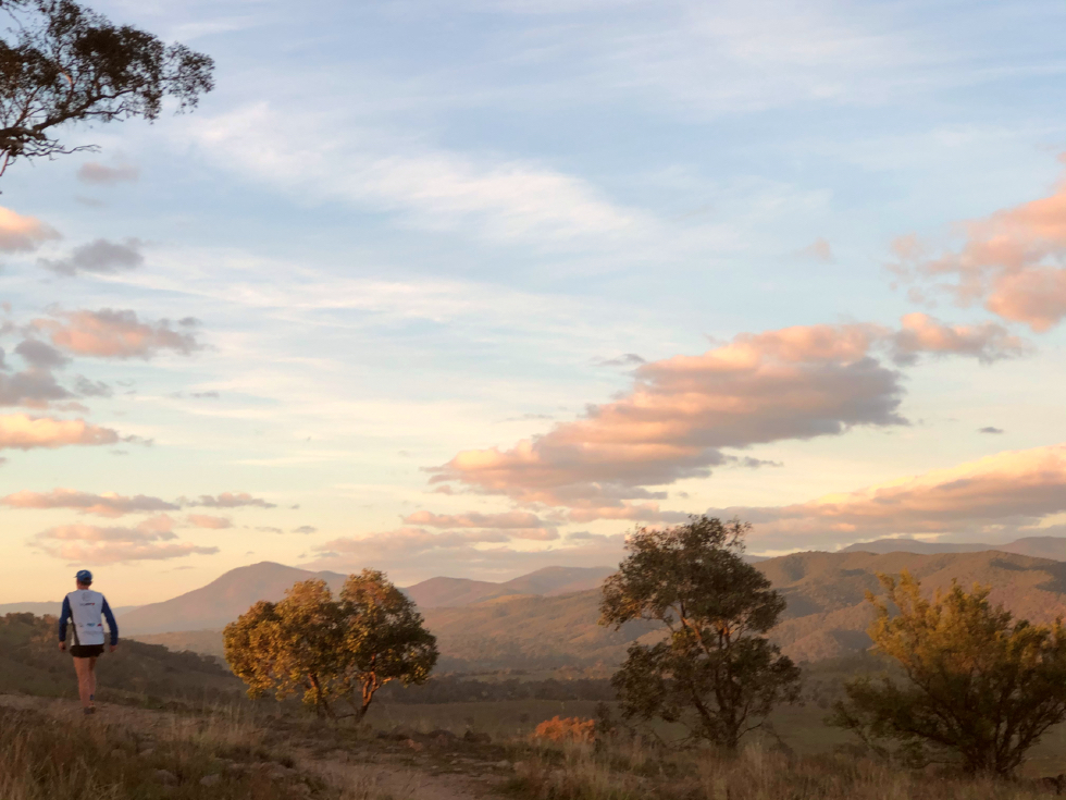
Hall is older than Canberra, and cross-country runs were held starting and finishing from Hall form the earliest days of organised runs in Canberra. The Hall Showground – the start/finish venue for the third of the Sri Chinmoy Canberra Trail Series – is an historic venue, which has hosted the National Sheep Dog Trials for the past 30 years. It boasts excellent facilities, including multiple showers and toilets.
The track from Hall through to Oak Hill is the Rolls Royce of Canberra Trails. Especially commissioned for the Centenary Trail project, this beautifully sculptured track is a work of art, a trail to fall in love with… With varying vistas in each direction, you really need to run this wonderful track both ways to fully appreciate it: hence the out-and-back option. Enjoy!
2km Novice Course
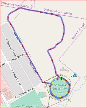
From the Start, head clockwise around the Hall Showground following the cones for 340m to exit left through a gate and then head 60m to turn right at Hall St (0.40K). Head up the hill, staying on the RHS of the road until you get to the top where you will continue straight onto the gravel road and the Centenary Trail (0.87K). After another 130m of gentle climb, turn right (1.00K) onto the single track to head downhill for only 100m before turning right to step over a fence (1.1K) and then turn left to continue downhill on the single track with the fence on your LHS. After a lovely winding run through the trees you will come to 2nd fence to step over on your left (1.56K). Now you will head straight towards the Showground on a dirt track – passing through an open swing gate 120m later (1.68K), and a 2nd open swing gate another 60m later (1.74K) to cross over to the entrance gate to the Showground (1.78K). (Yellow arrows) Turn left to cross over the Start mat again (1.80K) and run one more clockwise lap of the oval to reach the Finish timing mat near the Grey Shed (2.19K).
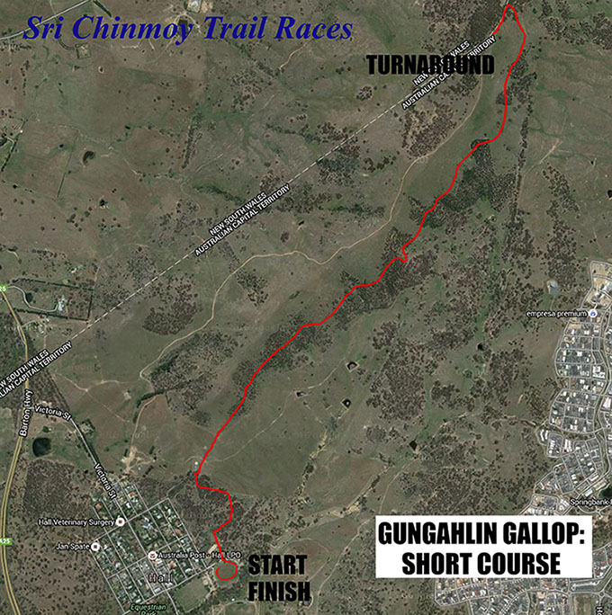
10km course
The 10km course is an out-and-back to the summit of One Tree Hill and return. The course starts with a loop of Hall Showground (300m) to get into a running rhythm. Pass through the gate at the western side of the Showground, cross the dirt access road into the grassy enclosure. At the north-western end of the grassy enclosure, climb over a stile (500m) and join the old Hall cross-country track through the bush. You will reach a fenceline, which you follow to the left (west) heading uphill. Climb another stile on your right (1.05K) to join a faint single track heading uphill, which joins with the Centenary Trail, Turn right here and almost immediately pass over or through a fence into open ground, heading north and uphill.
Follow the Centenary Trail along the side of the ridge through woodland. At 4.56km take the left hand fork to join the One Tree Hill summit trail, climbing steeply including some stairs to the summit of One Tree Hill (4.98km). Be sure to have your number recorded by the marshal, then turn around and return via the same route, including a lap of the Showground to finish.
View the 31km course map, and start/finish area.
Take a photo tour of the course.
Introduction
Hall is older than Canberra, and cross-country runs were held starting and finishing from Hall form the earliest days of organised runs in Canberra. The Hall Showground – the start/finish venue for the third of the Sri Chinmoy Canberra Trail Series – is an historic venue, which has hosted the National Sheep Dog Trials for the past 30 years. It boasts excellent facilities, including multiple showers and toilets.
The track from Hall through to Oak Hill is the Rolls Royce of Canberra Trails. Especially commissioned for the Centenary Trail project, this beautifully sculptured track is a work of art, a trail to fall in love with… With varying vistas in each direction, you really need to run this wonderful track both ways to fully appreciate it: hence the out-and-back option. Enjoy!
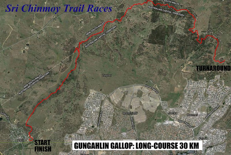
31km course
The 31km course is an out-and-back to the summit of Oak Hill and return. The course starts with a loop of Hall Showground (470m) to get into a running rhythm. Pass through the gate at the western side of the Showground, cross the dirt access road into the grassy enclosure. At the north-western end of the grassy enclosure, climb over a stile (670m) and join the old Hall cross-country track through the bush. You will reach a fenceline, which you follow to the left (west) heading uphill. Climb another stile on your right (1.2km) to join a faint single track heading uphill, which joins with the Centenary Trail. Turn right here and almost immediately pass over or through a fence into open ground, heading north and uphill.
Follow the Centenary Trail along the side of the ridge through woodland. At 4.93km take the left hand fork to join the One Tree Hill summit trail, climbing steeply including some stairs to the summit of One Tree Hill (5.17km). Be sure to have your number recorded by the marshal. Turn around here and descend again to turn left at the main track (5.6km).
Continue along the Centenary Trail N and E through varying terrain, a lovely mixture of shaded woodland with occasional open stretches for some sun and to enjoy the views back across northern Canberra and over into New South Wales. Most gates will be open, however some will be closed – these must be climbed over or through. After 13.8km you reach a small reservoir on your left, followed 200m later by the Northern Border Campground (water station). Continue uphill for a further 1km to the lookout at the summit of Oak Hill (marshal), with vistas across Gungahlin. Be sure to have your number recorded here. Turn around here and return via the same route – including the re-ascent and descent of One Tree Hill (be sure to have your number recorded here again!). Enjoy your victory lap back at the Hall Showground!
About the Organisers
The Sri Chinmoy Marathon Team
Serving the athletic community for over 40 years...

Team Founder Sri Chinmoy
A lifelong advocate of fitness and self-transcendence...
Other Upcoming Events
